Related Research Articles

Pearl Harbour is a small harbour at the head of the Waiau River, in the town of Manapouri on the South Island of New Zealand.

The Eglinton River is located in the region of Southland in the southwest of New Zealand. It flows through Fiordland National Park for 50 kilometres (31 mi). Its headwaters are at Lake Gunn, 25 kilometres (16 mi) east of Milford Sound, and it flows generally south before entering Lake Te Anau along the lake's eastern shore opposite the entrance to North Fiord.

Myall River, an open semi-mature brackish freshwater barrier estuary of the Mid-Coast Council system, is located in the Mid North Coast region of New South Wales, Australia.

The Mararoa River is one of the braided rivers of the Southland Region of the South Island of New Zealand.

The Hunter Mountains of Lake Manapouri, New Zealand, were named by surveyor James McKerrow after the famous anatomist John Hunter. The Hunter Mountain Range covers an area between The South Arm and Hope Arm of Lake Manapouri South to the Green Lake.
The Dark River, New Zealand is a river of Fiordland, New Zealand. It rises west of Barrier Peak and flows westward through Fiordland National Park into Lake Grave, which drains into Te Hāpua / Sutherland Sound.
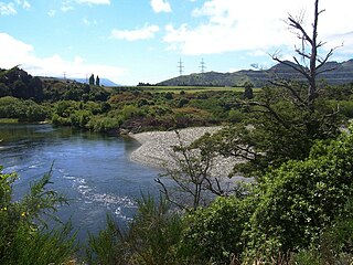
The Doon River is a river in Fiordland, in the Southland Region of New Zealand. It arises near Mount Donald and flows south-east into the south-west arm of Lake Te Anau.
The Elizabeth River, New Zealand is a river of Fiordland, New Zealand. It rises north of Mount George and flows westward through Fiordland National Park into the Malaspina Reach of Doubtful Sound at Olphert Cove. Elizabeth Island is in the Reach by the river mouth. The river and island were named by Captain John Grono after his brig Elizabeth in late 1822 or early 1823.
The Edith River is a river of Fiordland, New Zealand. It rises to the west of the Edith Saddle and flows westward into Lake Alice, which drains into George Sound.
The George River is a river of Fiordland, New Zealand. It rises south of Lake Beddoes and flows westward into George Sound at Anchorage Cove.
The Glaisnock River is a river in the Southland Region of New Zealand. It arises between the Stuart and Franklin Mountains, and flows east and south-east into the North Fiord of Lake Te Anau.
The Grebe River is a river in Fiordland, New Zealand. It arises north-west of Lake Monowai in an area once part of the lake but cut off by an enormous landslide about 13,000 years ago. The river now flows north, between the Townley Mountains to the west, and the Hunter Mountains to the east, and into Lake Manapouri's South Arm. Its major tributaries are Jaquiery Stream, Florence Stream, Emerald Stream, and Percy Stream, all from the west.
The Irene River is a river of New Zealand, flowing into Charles Sound, Fiordland.
The Juno River is a river of Fiordland, New Zealand. It rises west of Lake Shirley and flows westward into the Tasman Sea between Taitetimu / Caswell Sound and Taiporoporo / Charles Sound.
The Misty River is a river in Fiordland, New Zealand. It rises to the east of Irene Pass and flows westward into Teardrop Lake and on to Kaikiekie / Bradshaw Sound.
The Monowai River is a river in New Zealand, draining Lake Monowai into the Waiau River and feeding the Monowai Power Station.
The Rea River is a river in Fiordland, New Zealand. It rises west of Teardrop Lake and flows into Misty River before it enters Kaikiekie / Bradshaw Sound.
The Upukerora River is a river in New Zealand, flowing into Lake Te Anau north of Te Anau township.
The Spey River is a river in the Southland Region of New Zealand. Its entire length lies within the Fiordland National Park. The Spey rises at the Mckenzie Pass and Murrell's Pass either side of Mt Horatio (1,380 metres, and the river flows in a northeasterly direction, emptying into the West Arm of Lake Manapouri adjacent to the intake of the Manapouri Power Station. The Dusky Track follows the Spey valley for much of the river's length.
The Wapiti River is a river in the Southland Region of New Zealand. It rises in the northern extremity of the Stuart Mountains in Fiordland National Park, the top of its watershed being part of the main divide. Two branches feed Lake Sutherland, the outflow of which flows southwest to Lake Thomson. A further 2.2 kilometres (1.4 mi) reach of the river heads east to Lake Hankinson, which is separated from the North West Arm of the Middle Fiord of Lake Te Anau by a final 0.6-kilometre (0.4 mi) stretch of the river.
References
- ↑ Peter Dowling, ed. (2004). Reed New Zealand Atlas. Reed Books. pp. map 105. ISBN 0-7900-0952-8.
- Land Information New Zealand - Search for Place Names