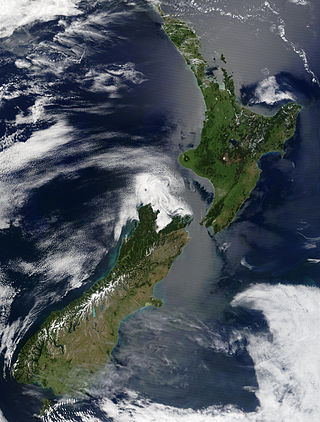
New Zealand is an island country located in the southwestern Pacific Ocean, near the centre of the water hemisphere. It consists of a large number of islands, estimated around 700, mainly remnants of a larger landmass now beneath the sea. The land masses by size are the South Island and the North Island, separated by the Cook Strait. The third-largest is Stewart Island / Rakiura, located 30 kilometres off the tip of the South Island across Foveaux Strait. Other islands are significantly smaller in area. The three largest islands stretch 1,600 kilometres across latitudes 35° to 47° south. New Zealand is the sixth-largest island country in the world, with a land size of 268,680 km2 (103,740 sq mi).

Fiordland, is a non-administrative geographical region of New Zealand in the south-western corner of the South Island, comprising the western third of Southland. Most of Fiordland is dominated by the steep sides of the snow-capped Southern Alps, deep lakes, and its steep, glacier-carved and now ocean-flooded western valleys. The name "Fiordland" derives from an alternate spelling of the Scandinavian word for steep glacial valleys, "fjord". The geographic area of Fiordland is dominated by, and roughly coterminous with, Fiordland National Park, New Zealand's largest national park.

Fiordland National Park is a national park in the south-west corner of South Island of New Zealand. It is the largest of the 13 national parks in New Zealand, with an area covering 12,607 km2 (4,868 sq mi), and a major part of the Te Wāhipounamu a UNESCO World Heritage Site established in 1990. The park is administered by the Department of Conservation. The southern ranges of the Southern Alps cover most of Fiordland National Park, combined with the deep glacier-carved valleys.

Manapouri is a small town in Southland / Fiordland, in the southwest corner of the South Island, in New Zealand. The township is the westernmost municipality in New Zealand. Located at the edge of the Fiordland National Park, on the eastern shore of Lake Manapouri, close to its outflow into the Waiau River, tourist boat services are based in the town.

Secretary Island is an island in southwestern New Zealand, lying entirely within Fiordland National Park. Roughly triangular in shape, it lies between Doubtful Sound / Patea in the south and Te Awa-o-Tū / Thompson Sound in the north, with its west coast facing the Tasman Sea. To the east of the island, Pendulo Reach connects Te Awa-o-Tū / Thompson Sound with Doubtful Sound / Patea. Steeply sloped, the entirely bush-clad island rises to a chain of several peaks higher than 1000 metres. The highest of these is the 1,196-metre (3,924 ft) Mount Grono, the highest peak in the main New Zealand chain not located in the North or South Island. The island also contains three lakes. The largest, Secretary Lake, over 600 metres (2,000 ft) long, is located beneath Mount Grono at an altitude of 550 metres (1,800 ft).

Lake Marian is an alpine lake at the southern end of the Darran Mountains in the Fiordland National Park in the South Island of New Zealand. The lake is located just above the treeline in a hanging valley leading northwest from the Hollyford Valley near The Divide pass. The valley is sheltered by steep snow-covered peaks of over 2,000 metres (6,600 ft) on all sides apart from the entrance.

Sigaus tumidicauda is a species of alpine grasshopper, endemic to New Zealand. Like all of New Zealand sub-alpine and alpine grasshoppers, S. tumidicauda has a 2- or 3-year life cycle. The eggs must "overwinter" before they will hatch. Hoppers are found throughout the year, and adult grasshoppers can be found throughout the New Zealand summer between December and April. This grasshopper is flightless.

Southland is New Zealand's southernmost region. It consists of the southwestern portion of the South Island and includes Stewart Island. Southland is bordered by the culturally similar Otago Region to the north and east, and the West Coast Region in the extreme northwest. The region covers over 3.1 million hectares and spans 3,613 km of coastline. As of June 2023, Southland has a population of 103,900, making it the eleventh-most-populous New Zealand region, and the second-most sparsely populated. Approximately half of the region's population lives in Invercargill, Southland's only city.

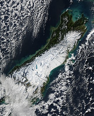
The South Island, with an area of 150,437 km2 (58,084 sq mi), is the largest landmass of New Zealand; it contains about one-quarter of the New Zealand population and is the world's 12th-largest island. It is divided along its length by the Southern Alps, the highest peak of which is Aoraki / Mount Cook at 3,724 metres (12,218 ft), making it 9th-highest island, with the high Kaikōura Ranges to the northeast. There are eighteen peaks of more than 3,000 metres (9,800 ft) in the South Island. The east side of the island is home to the Canterbury Plains while the West Coast is famous for its rough coastlines such as Fiordland, a very high proportion of native bush, and Fox and Franz Josef Glaciers. The dramatic landscape of the South Island has made it a popular location for the production of several films, including The Lord of the Rings trilogy and The Chronicles of Narnia: The Lion, the Witch and the Wardrobe. It lies at similar latitudes to Tasmania, and parts of Patagonia in South America.

Mount Eglinton is an 1,854-metre-elevation (6,083-foot) mountain summit in the Fiordland Region of New Zealand.

Mount Gifford is a 2,149-metre-elevation (7,051-foot) mountain in Fiordland, New Zealand.

Mount Gunn is a 2,044-metre-elevation (6,706-foot) mountain in Southland New Zealand.

Mount Christina is a 2,474-metre-elevation (8,117-foot) mountain in Fiordland, New Zealand.

Mount Pembroke is a 2,015-metre-elevation (6,611-foot) mountain in Fiordland, New Zealand.

Mount Talbot is a 2,105-metre-elevation (6,906-foot) mountain in Fiordland, New Zealand.

Mount Huxley is a 2,505-metre-elevation (8,219-foot) mountain in New Zealand.

Poseidon Peak is a 2,229-metre-elevation (7,313-foot) mountain in Fiordland, New Zealand.

Pyramid Peak is a 2,295-metre-elevation (7,530-foot) mountain summit in the Fiordland Region of New Zealand.

Mount Elliot is a 1,990-metre-elevation (6,529-foot) mountain in Fiordland, New Zealand.


