
Bluff, previously known as Campbelltown and often referred to as "The Bluff", is a town and seaport in the Southland region, on the southern coast of the South Island of New Zealand. It is the southernmost town in mainland New Zealand and, despite Slope Point and Stewart Island being further south, Bluff is colloquially used to refer to the southern extremity of the country. According to the 2018 census, the resident population was 1,797, a decrease of 6 since 2013.
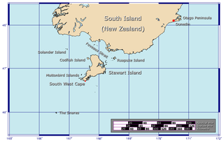
Foveaux Strait is a strait that separates Stewart Island from the South Island of New Zealand. The width of the strait ranges from about 23 to 53 km and the depth varies between 18 and 46 m. Captain James Cook passed around the southern tip of Stewart Island during his circumnavigation of the South Island in 1770 but did not record the presence of a seaway between Stewart Island and the mainland. The strait was not charted until 1804 when an American sealer, Owen Folger Smith, mapped it.
The Southland Plains is a general name given to several areas of low-lying land in the South Island of New Zealand, separated by the rise of the Hokonui Hills in the north. It forms a sizeable area of Southland region and encompasses its two principal settlements the city of Invercargill and the town of Gore. The Southland Plains include some of New Zealand's most fertile farmland.

The Awarua Plain is a large area of wetland to the east of Bluff, New Zealand. Covering an area of around 600 km², the plain stretches for 35 kilometres along the coast of Foveaux Strait. This stretch of coast includes the peninsula of Tiwai Point, Awarua Bay, the Waituna Lagoon, and Toetoes Bay. The Mataura River is the major river responsible for the presence of the Awarua Plain; along with the Ōreti River, it is a remnant of the rivers from the Ice Ages that formed the Southland Plains (Murihiku). In addition, several small streams enter Foveaux Strait along this stretch of coast, mainly via Awarua Bay and Waituna Lagoon.

Toetoes Bay is the easternmost of three large bays lying on the Foveaux Strait coast of Southland, New Zealand, the others being Te Waewae Bay and Oreti Beach. The 240 km Mataura River drains to sea at Toetoes Bay, first passing through the Toetoes Harbour estuary. Thirty kilometres in length, the bay is the southern end of the Awarua Plain, an area of swampy land stretching inland for about fifteen kilometres. The eastern end of the bay is close to Slope Point, the South Island's southernmost point, and the western end of the Catlins.

The Ōreti River is one of the main rivers of Southland, New Zealand, and is 170 kilometres (110 mi) long. The river has been identified as an Important Bird Area by BirdLife International because, for much of its length, it supports breeding colonies of black-billed gulls.
The Aparima River, earlier known as Jacob's River, is one of the southward-flowing braided rivers of Southland, New Zealand.

Stewart Island is New Zealand's third-largest island, located 30 kilometres south of the South Island, across Foveaux Strait. It is a roughly triangular island with a total land area of 1,746 km2 (674 sq mi). Its 164-kilometre (102 mi) coastline is deeply indented by Paterson Inlet (east), Port Pegasus (south), and Mason Bay (west). The island is generally hilly and densely forested. Flightless birds, including penguins, thrive because there are few introduced predators. Almost all the island is owned by the New Zealand government, and over 80 per cent of the island is set aside as the Rakiura National Park.

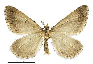
Asaphodes aegrota is a species of moth in the family Geometridae. It was first described by Arthur Gardiner Butler in 1879 as Selidosema aegrota. It is endemic to New Zealand and can be found in the North, South and Stewart Islands. This species inhabits open spaces in lowland native forest. The larvae of A. aegrota feed on native herbs and have also been observed feeding of the introduced lawn daisy. The adults are variable in appearance with the markings on both sides of its wings varying in intensity. Some populations also have narrow winged females. Adults are on the wing from November until March.
Bluff Harbour is a harbour and lagoon in the South Island of New Zealand, adjacent to the town of Bluff. The main port facilities are located close to the entrance from Foveaux Strait of a large natural inlet which includes a large, low-lying eastern arm, Awarua Bay, immediately to the east of the promontory which gives the town and harbour its name.
Greenhills is a suburb of New Zealand's southernmost city, Invercargill.
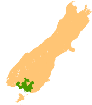
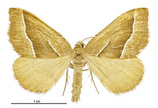
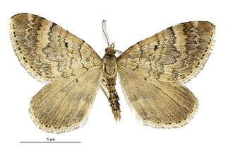
Asaphodes frivola, also known as the remuremu looper moth or Foveaux looper moth, is a species of moth in the family Geometridae with flightless females. It is endemic to New Zealand, and critically endangered, occurring in a very narrow and specialised habitat at just two small coastal sites near Invercargill.

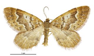
Asaphodes imperfecta is a moth in the family Geometridae. It is endemic to New Zealand and is found in the southern part of the South Island. The species inhabits low lying swampy native forest. The host plants of the larvae of this species is unknown. The adults are on the wing in December and January. It is classified as critically endangered by the Department of Conservation.

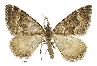
Asaphodes obarata is a moth in the family Geometridae. It is endemic to New Zealand and has been collected in both the North and South Islands. It seems to inhabit the margins of native forest and also frequents plains, with an affinity for gorse hedges. The host plants of the larvae of this species are unknown. The adults are on the wing in December and January. It is classified as critically endangered by the Department of Conservation. There has been a contraction of range of A. obarata with it now being regarded as locally extinct in both Dunedin and Invercargill.
Asaphodes stinaria is a moth in the family Geometridae. It is endemic to New Zealand and has previously been observed in both the North and South Islands. The range of this species has contracted and it has recently only been located in Westland, Otago and Southland. This species inhabits wetlands, tussock country, and in grassy openings in native forest. The larval host species has been hypothesised as being 'hairy' Ranunculus species however as at 2000 this hasn't been confirmed. It is classified as Nationally Vulnerable by the Department of Conservation. There has been considerable reductions of the range of this species with it possibly becoming extinct in eastern parts of New Zealand.
Asaphodes dionysias is a species of moth in the family Geometridae. This species is endemic to New Zealand and is only known from mountainous areas in Central Otago. It lives in open grassy mountainous habitat at altitudes up to 1750 m. It is also known to live in wetland habitat. The larvae of this species feed on native herbs. The adults of this species are on the wing in January and February. The adult female of the species has reduced wing size in comparison to the male.
Asaphodes exoriens is a species of moth in the family Geometridae. This species is endemic to New Zealand and has been found in Central Otago. This is an alpine species and frequents open grassy habitat. They can also be found in upland wetland habitat at altitudes between 800 and 1100 m. Adults are on the wing in March.
Asaphodes ida is a species of moth in the family Geometridae. It is endemic to New Zealand. This moth can be found in upland or alpine habitat in Canterbury and Otago. Although not classified under the New Zealand Threat Classification system, this species is regarded as rare.
Woodend is a rural suburb of the New Zealand city of Invercargill.

Asaphodes philpotti is a moth in the family Geometridae. It is endemic to New Zealand and has been found in the South Island as well as one observation in Wainuiomata in the North Island. This species inhabits native forest and larvae are hosted by species in the genera Hydrocotyle and Cardamine.

