
Invercargill is the southernmost and westernmost city in New Zealand, and one of the southernmost cities in the world. It is the commercial centre of the Southland region. The city lies in the heart of the wide expanse of the Southland Plains to the east of the Ōreti or New River some 18 km north of Bluff, which is the southernmost town in the South Island. It sits amid rich farmland that is bordered by large areas of conservation land and marine reserves, including Fiordland National Park covering the south-west corner of the South Island and the Catlins coastal region.

Riverton, officially Riverton / Aparima, is a small New Zealand town 30 kilometres (19 mi) west of Invercargill, on the south-eastern shorelines of the Jacobs River Estuary. The estuary is formed by the Aparima and Pourakino rivers, leading through a narrow outflow channel into Foveaux Strait. Accessible via State Highway 99 on the Southern Scenic Route, the main part of the town is on flat land and the northern end of Oreti Beach. South Riverton is built on the hills between the eastern shore of the estuary and Taramea Bay.

Bluff, previously known as Campbelltown and often referred to as "The Bluff", is a town and seaport in the Southland region, on the southern coast of the South Island of New Zealand. It is the southernmost town in mainland New Zealand and, despite Slope Point and Stewart Island being further south, Bluff is colloquially used to refer to the southern extremity of the country. According to the 2018 census, the resident population was 1,797, a decrease of 6 since 2013.
The Southland Plains is a general name given to several areas of low-lying land in the South Island of New Zealand, separated by the rise of the Hokonui Hills in the north. It forms a sizeable area of Southland region and encompasses its two principal settlements the city of Invercargill and the town of Gore. The Southland Plains include some of New Zealand's most fertile farmland.

The Southland Province was a province of New Zealand from March 1861, when it split from Otago Province, until 1870, when it rejoined Otago.
Queens Park is a park in Invercargill, New Zealand, and was part of the original plan when Invercargill was founded in 1856. The park is 200 acres (0.81 km2) in extent. It is just north of the city centre, bounded by Queens Drive to the east, Kelvin Street to the west, Gala Street to the south and Herbert Street to the north. The Gala Street entrance features the Feldwick Gates, built in 1924 and named after John Feldwick, brother of MP Henry Feldwick.

Dacre is a small town in the South Island of New Zealand. It is situated on the Southland Plains between Invercargill and Edendale on State Highway 1. In Dacre, SH 1 is met by State Highway 98, which runs west to Makarewa via Rakahouka. Nearby villages include Mabel Bush to the northwest and Woodlands to the southeast. Dacre is 25 km north east of Invercargill, the closest city. The Main South Line railway passes just to the south of Dacre. It is a dairy farming community, that currently has a community hall and a small engine garage.

Invercargill Passenger Transport Ltd was a bus company which operated public transport routes in Dunedin and Invercargill as well as school transport services in those cities as well as Queenstown and leisure and tourism transport services throughout the South Island of New Zealand

James Walker Bain was a 19th-century New Zealand politician. He was a significant businessman in Invercargill and Southland.

State Highway 6 is a major New Zealand state highway. It extends from the Marlborough region in the northeastern corner of the South Island across the top of the island, then down the length of the island, initially along the West Coast and then across the Southern Alps through inland Otago and finally across the Southland Plains to the island's south coast. Distances are measured from north to south.

The Southland Times is the regional daily paper for Southland, including Invercargill, and neighbouring parts of Otago, in New Zealand. It is now owned by media business Stuff Ltd, formerly the New Zealand division of Fairfax Media.
The Mayor of Invercargill is the head of the municipal government of Invercargill, New Zealand, and leads the Invercargill City Council. The mayor is directly elected using a First Past the Post electoral system every three years. The current mayor is Nobby Clark. Invercargill also has a deputy mayor that is chosen from the council. There have been 44 mayors so far.

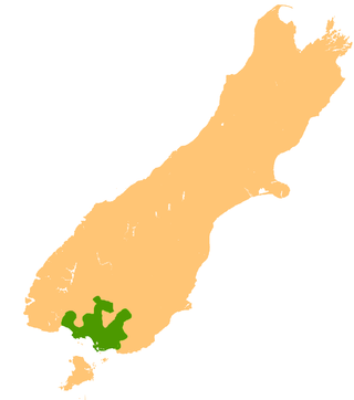
Southland is New Zealand's southernmost region. It consists of the southwestern portion of the South Island and includes Stewart Island. Southland is bordered by the culturally similar Otago Region to the north and east, and the West Coast Region in the extreme northwest. The region covers over 3.1 million hectares and spans 3,613 km of coastline. As of June 2023, Southland has a population of 103,900, making it the eleventh-most-populous New Zealand region, and the second-most sparsely populated. Approximately half of the region's population lives in Invercargill, Southland's only city.
James William Hugh Bannerman was a New Zealand journalist, historian, cricketer and soldier.
The Australian cricket team toured New Zealand in January and February 1881. The Australians played ten matches against provincial teams, nine of which fielded 22 players with the aim of providing more evenly-matched contests. Two further brief matches were played to fill the allotted time after a scheduled match finished early. As none of the matches were 11-a-side they are not considered to have been first-class.

Kew is a suburb in the New Zealand city of Invercargill.
The 2022 Invercargill mayoral election took place on 8 October 2022 as part of the New Zealand local elections. Incumbent mayor Tim Shadbolt unsuccessfully sought a tenth term against nine other candidates, losing to his deputy Nobby Clark.
Invercargill Central is a shopping centre located in the central business district of Invercargill, New Zealand. Stage one of the project opened on 14 July 2022.

Francis Russell Miller was a New Zealand politician who served as Mayor of Invercargill from 1971 to 1983.
 Pre-2018 signpost with incorrect distances and coordinates
 Signpost in late-2018 with information corrected and Suqian added

