Tisbury, New Zealand

Last updated

Tisbury
Tisbury, New Zealand
Coordinates: 46°26′40″S168°23′58″E / 46.4445°S 168.3994°E / -46.4445; 168.3994 Coordinates: 46°26′40″S168°23′58″E / 46.4445°S 168.3994°E / -46.4445; 168.3994
Country New Zealand
City Invercargill
Local authority Invercargill City Council
Area
[1]
  Land821 ha (2,029 acres)
Population
 (2018 Census) [2]
  Total366
Strathern Rockdale Kennington
Kingswell
Pfeil oben.svg
Pfeil links.svgTisburyPfeil rechts.svg
Pfeil unten.svg
Waimatua
Clifton Woodend Motu Rimu

Tisbury is a suburb of New Zealand's southernmost city, Invercargill.

Contents

The unsteady climate often affect crops in Tisbury. In 2015 the cold weather continued till Christmas and vegetable farmers were unable to yield crops in time. [3]

Demographics

Historical population for Tisbury
YearPop.±% p.a.
2006357    
2013402+1.71%
2018366−1.86%
Source: [2]

Tisbury covers 8.21 km2 (3.17 sq mi) [1] and is part of the Kennington-Tisbury statistical area. It had a population of 366 at the 2018 New Zealand census, a decrease of 36 people (−9.0%) since the 2013 census, and an increase of 9 people (2.5%) since the 2006 census. There were 141 households. There were 201 males and 162 females, giving a sex ratio of 1.24 males per female, with 66 people (18.0%) aged under 15 years, 48 (13.1%) aged 15 to 29, 201 (54.9%) aged 30 to 64, and 51 (13.9%) aged 65 or older.

Ethnicities were 91.0% European/Pākehā, 13.1% Māori, 0.8% Pacific peoples, and 4.1% Asian (totals add to more than 100% since people could identify with multiple ethnicities).

Although some people objected to giving their religion, 51.6% had no religion, 37.7% were Christian, 0.8% were Buddhist and 0.8% had other religions.

Of those at least 15 years old, 39 (13.0%) people had a bachelor or higher degree, and 75 (25.0%) people had no formal qualifications. The employment status of those at least 15 was that 159 (53.0%) people were employed full-time, 51 (17.0%) were part-time, and 6 (2.0%) were unemployed. [2]

Kennington-Tisbury statistical area

Kennington-Tisbury covers 37.11 km2 (14.33 sq mi) [1] and had an estimated population of 1,580 as of June 2021, [4] with a population density of 43 people per km2.

Historical population for Kennington-Tisbury
YearPop.±% p.a.
20061,092    
20131,317+2.71%
20181,443+1.84%
Source: [5]

Kennington-Tisbury had a population of 1,443 at the 2018 New Zealand census, an increase of 126 people (9.6%) since the 2013 census, and an increase of 351 people (32.1%) since the 2006 census. There were 528 households. There were 756 males and 687 females, giving a sex ratio of 1.1 males per female. The median age was 43.5 years (compared with 37.4 years nationally), with 306 people (21.2%) aged under 15 years, 189 (13.1%) aged 15 to 29, 723 (50.1%) aged 30 to 64, and 228 (15.8%) aged 65 or older.

Ethnicities were 92.7% European/Pākehā, 12.3% Māori, 0.8% Pacific peoples, 2.3% Asian, and 1.5% other ethnicities (totals add to more than 100% since people could identify with multiple ethnicities).

The proportion of people born overseas was 8.3%, compared with 27.1% nationally.

Although some people objected to giving their religion, 50.5% had no religion, 42.4% were Christian, 0.4% were Buddhist and 0.6% had other religions.

Of those at least 15 years old, 174 (15.3%) people had a bachelor or higher degree, and 252 (22.2%) people had no formal qualifications. The median income was $39,700, compared with $31,800 nationally. 234 people (20.6%) earned over $70,000 compared to 17.2% nationally. The employment status of those at least 15 was that 627 (55.1%) people were employed full-time, 207 (18.2%) were part-time, and 24 (2.1%) were unemployed. [5]

Education

Tisbury School is a state school for years 1 to 6 [6] with a roll of 111 students as of July 2022. [7] The school was established in 1891, but it was destroyed by a fire in 1945 and the present classroom block was built to replace it. [8]

Related Research Articles

<span class="mw-page-title-main">Riwaka</span> Place in Tasman, New Zealand

Riwaka is a small settlement in the Tasman District of New Zealand's South Island. It lies beside Tasman Bay / Te Tai-o-Aorere, five kilometres north of Motueka, and close to the mouth of the Riuwaka River.

Glenavy is a small town in the South Island of New Zealand. It is located at the southern extreme of the Canterbury region on the alluvial fan of the Waitaki River, three kilometres from the river's outflow into the Pacific Ocean.

<span class="mw-page-title-main">West Melton, New Zealand</span> Minor urban area in Canterbury, New Zealand

West Melton is a town located west of Christchurch in the Canterbury region of New Zealand's South Island.

<span class="mw-page-title-main">Hawarden, New Zealand</span> Town in Canterbury, New Zealand

Hawarden is a small town in the Canterbury region of New Zealand's South Island. It is located near Waikari, just off State Highway 7.

Kennington is a town located in the Southland region of New Zealand’s South Island. It is situated on the Waihopai River on the eastern outskirts of the city of Invercargill. Other nearby settlements include Longbush, Myross Bush, Motu Rimu, and Woodlands.

Myross Bush is a rural community on the northeastern outskirts of the city of Invercargill in the Southland region of New Zealand's South Island. Other nearby settlements include Makarewa to the northwest, Rakahouka and Roslyn Bush to the northeast, and Kennington to the southeast.

<span class="mw-page-title-main">Dunsandel</span> Town in Canterbury, New Zealand

Dunsandel is a small rural town in the Canterbury region of the South Island, New Zealand. The town is located on the Canterbury Plains just south of the Selwyn River / Waikirikiri and about 40 km south of Christchurch. Dunsandel is a junction town on SH1, halfway between Christchurch and Ashburton, with roads leading to Leeston, Southbridge and Hororata. The town provides an important refreshment stop for main road travellers with eateries and coffee shops, as well as acting as a support town for the rural hinterland.

Wallacetown is a small town in Southland, in the South Island of New Zealand. Wallacetown is to the west of Invercargill, on high ground between the Makarewa and Ōreti rivers, near the Ōreti's estuary. Both rivers are popular for trout and whitebait fishing. It is considered to be a satellite town of Invercargill. It is served by State Highway 99, which skirts the town's northern edge.

Pamapuria is a locality in Northland, New Zealand. It lies on State Highway 1 about 10 km east of Kaitaia.

<span class="mw-page-title-main">Pohangina</span> Village in Manawatū-Whanganui region, New Zealand

Pohangina is a small rural community in the Manawatū-Whanganui region of New Zealand, just north of Ashhurst.

<span class="mw-page-title-main">Broadwood, New Zealand</span> Place in Northland Region, New Zealand

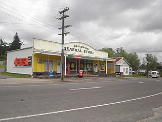
Broadwood is a town about 25 km to the north of the north side of the Hokianga harbour, in Northland, New Zealand. Herekino is 21 km to the west, and Mangamuka Bridge is the same distance to the east.

Maromaku is a locality in the Northland Region of the North Island of New Zealand. Kawakawa is north, and Towai is southeast. State Highway 1 runs past Maromaku to the north, and the North Auckland Line runs through it.

<span class="mw-page-title-main">Tuamarina</span> Place in Marlborough, New Zealand

Tuamarina is a small town in Marlborough, New Zealand. State Highway 1 runs through the area. The Tuamarina River joins the Wairau River just south of the settlement. Picton is about 18 km to the north, and Blenheim is about 10 km to the south.

Stirling is a settlement in New Zealand. It is located in South Otago, approximately 5 km from Balclutha, and just north of the Matau Branch of the Clutha River.

Riversdale is a small town in the Southland region of New Zealand.

<span class="mw-page-title-main">Saint Andrews, Canterbury</span> Rural settlement in Canterbury, New Zealand

St Andrews is a small town in the south Canterbury region of New Zealand's South Island. It is located on State Highway 1 five kilometres south of Pareora and 17 kilometres south of Timaru. It was linked to Timaru by rail in 1876, and grew after the subdivision of the Pareora Run. It remains a rural service town.

<span class="mw-page-title-main">Ashley, New Zealand</span> Town in Canterbury, New Zealand

Ashley is a small town in North Canterbury, in the South Island of New Zealand. It used to have a railway station on the Main North Line that runs through the village.

<span class="mw-page-title-main">Tai Tapu</span> Place in South Island, New Zealand

Tai Tapu, previously known as Taitapu, is a small town adjacent to the Halswell River and nestled in the Port Hills, located 6 km east of the town of Lincoln and 18 km south west of Christchurch in the Canterbury region of New Zealand's South Island. State Highway 75 passes through the centre of the village, connecting Christchurch with Akaroa and the Banks Peninsula.

Kerepehi is a rural community in the Hauraki District and Waikato region of New Zealand's North Island. The alternative spelling Kerepeehi was in use until 1933.

Hiwinui is a settlement in Manawatu District, in the Manawatū-Whanganui region in New Zealand's central North Island.

References

  1. 1 2 3 "ArcGIS Web Application". statsnz.maps.arcgis.com. Retrieved 20 February 2022.
  2. 1 2 3 "Statistical area 1 dataset for 2018 Census". Statistics New Zealand. March 2020. 7029801–7029802 and 7029836.
  3. crop growing in Tisbury
  4. "Population estimate tables - NZ.Stat". Statistics New Zealand . Retrieved 22 October 2021.
  5. 1 2 "Statistical area 1 dataset for 2018 Census". Statistics New Zealand. March 2020. Kennington-Tisbury (362300). 2018 Census place summary: Kennington-Tisbury
  6. Education Counts: Tisbury School
  7. "New Zealand Schools Directory". New Zealand Ministry of Education. Retrieved 19 August 2022.
  8. "Our History". Tisbury School. Retrieved 20 February 2022.