Related Research Articles
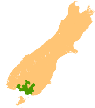
The Southland Plains is a general name given to several areas of low-lying land in the South Island of New Zealand, separated by the rise of the Hokonui Hills in the north. It forms a sizeable area of Southland region and encompasses its two principal settlements the city of Invercargill and the town of Gore. The Southland Plains include some of New Zealand's most fertile farmland.

St. Mary's Basilica is a Catholic Church in Invercargill, New Zealand. It was designed by the celebrated New Zealand architect, Francis Petre and was opened in 1905.
Queens Park is a park in Invercargill, New Zealand, and was part of the original plan when Invercargill was founded in 1856. The park is 200 acres (0.81 km2) in extent. It is just north of the city centre, bounded by Queens Drive to the east, Kelvin Street to the west, Gala Street to the south and Herbert Street to the north. The Gala Street entrance features the Feldwick Gates, built in 1924 and named after John Feldwick, brother of MP Henry Feldwick.
Drummond is a small town in Southland, New Zealand. It is 35 kilometres (22 mi) north of Invercargill and 18 kilometres (11 mi) west of Winton.

Dacre is a small town in the South Island of New Zealand. It is situated on the Southland Plains between Invercargill and Edendale on State Highway 1. In Dacre, SH 1 is met by State Highway 98, which runs west to Makarewa via Rakahouka. Nearby villages include Mabel Bush to the northwest and Woodlands to the southeast. Dacre is 25 km north east of Invercargill, the closest city. The Main South Line railway passes just to the south of Dacre. It is a dairy farming community, that currently has a community hall and a small engine garage.
Longbush is a community in the Southland region of New Zealand's South Island. It is located in a rural area outside the city of Invercargill on the banks of the Waihopai River. Just to the northeast is the larger town of Woodlands.There are two possible origins of the name Longbush, with one being that it is simply named after the shape of the bush. The second, however, is that it was named by the first travellers between Invercargill and Dunedin "and used the term as an indication of the length and weariness of the journey."
Roslyn Bush is a lightly populated locality on the northeastern outskirts of the city of Invercargill in the Southland region of New Zealand's South Island. Other nearby settlements include Makarewa to the west, Myross Bush to the southwest, Kennington to the south, Longbush and Woodlands to the east, and Rakahouka to the northeast.
Te Tipua is a rural farming community in the eastern Southland region of New Zealand's South Island.

Anderson Park is a park in Invercargill, New Zealand. It consists of a Georgian-style residence set in 24 hectares of landscaped gardens. The house displays Invercargill's extensive collection of New Zealand art.
Gorge Road is a locality in the Southland region of New Zealand's South Island. It is on the Southern Scenic Route and is situated on the western bank of the Mataura River. Nearby settlements include Ashers to the west, and across the Mataura, Pine Bush and Titiroa to the east.
Kapuka is a locality in the Southland region of New Zealand's South Island. It is situated between Mokotua to the west and Ashers to the east on the Southern Scenic Route; Oteramika is to the north, and Kapuka South, Waituna Lagoon, and Toetoes Bay are to the south.
Oteramika is a locality in the Southland region of New Zealand's South Island. It is in a rural setting near Waituna and Woodlands to the north, Rimu to the west, and to the south on the Southern Scenic Route are Mokotua, Kapuka, and Ashers. The major centre of Southland, Invercargill, is over 15 km west.
Lorneville is a small settlement on the northern outskirts of Invercargill, in Southland, New Zealand. It is located on State Highway 6, at the junction with State Highways 98 and 99, and is thus also on the Southern Scenic Route.
The Waihopai River — the more southerly of two New Zealand rivers of that name — runs through the South Island's Southland Region. A narrow stream for much of its 40-kilometre (25 mi) length, it has its source in several streams arising in low hill country between Edendale and Dacre, all of which run generally west-southwest, passing through or close to the township of Woodlands. These streams gradually merge, becoming one river some 15 kilometres (9 mi) east of Invercargill. The Waihopai runs west from this point, passing through the northern suburbs of Invercargill City and then turns south, running between Invercargill's built-up area and Invercargill Airport, before flowing into the northern end of the New River Estuary at Stead Street Bridge.

Stirling Point is a landmark at the southern end of the New Zealand town of Bluff, New Zealand. It is notable as the southern end of both State Highway 1 and Te Araroa; both these facilities span the length of the country. Stirling Point hosts a signpost with multiple directional signs; it is one of the most photographed items in Southland. Stirling Point has an anchor chain sculpture which replicates the sculpture on Stewart Island.
Greenhills is a suburb of New Zealand's southernmost city, Invercargill.
Mataura Island is a farming community in Southland, New Zealand. It is located close to the east bank of the lower reaches of the Mataura River. Despite its name, it is no longer an island. Mataura Island is located some 40 kilometres (25 mi) east of the region's main city of Invercargill, and 15 kilometres (9.3 mi) south of the town of Edendale, on the Awarua Plains and close to the western edge of The Catlins.

The Civic Theatre is a theatrical venue in the southern New Zealand city of Invercargill.

The Southern District Health Board was a district health board which provided healthcare to an area covering the southern half of the South Island of New Zealand. In July 2022, the Southern DHB was dissolved as part of a nationwide overhaul of the district health board system. Its former functions and responsibilities were taken over by Te Whatu Ora.

Surrey Park is a major sports venue, located in the Invercargill, New Zealand suburb of Glengarry, 2 km to the east of the city centre.
References
| | This Southland Region geography article is a stub. You can help Wikipedia by expanding it. |