
The Waikato is a region of the upper North Island of New Zealand. It covers the Waikato District, Waipa District, Matamata-Piako District, South Waikato District and Hamilton City, as well as Hauraki, Coromandel Peninsula, the northern King Country, much of the Taupō District, and parts of the Rotorua Lakes District. It is governed by the Waikato Regional Council.
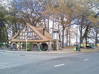
Matamata is a town in Waikato, New Zealand. It is located near the base of the Kaimai Ranges, and is a thriving farming area known for Thoroughbred horse breeding and training pursuits. It is part of the Matamata-Piako District, which takes in the surrounding rural areas, as well as Morrinsville and Te Aroha. State Highway 27 and the Kinleith Branch railway run through the town. The town has a population of 9,610 as of June 2024.

Matamata-Piako District is a local government area in the Waikato region of New Zealand. It lies to the east of the city of Hamilton.
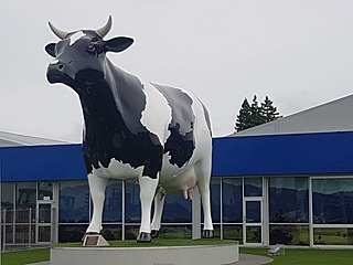
Morrinsville is a provincial town in the Waikato region of New Zealand's North Island, with an estimated population of 9,710 as of June 2024. The town is located at the northern base of the Pakaroa Range, and on the south-western fringe of the Hauraki Plains. Morrinsville is around 33 kilometres east of Hamilton and 22 kilometres west of Te Aroha. The town is bordered by the Piako River to the east and the Waitakaruru Stream to the south.
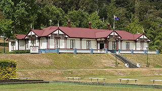
Te Aroha is a rural town in the Waikato region of New Zealand with a population of 3,906 people in the 2013 census, an increase of 138 people since 2006. It is 53 km (33 mi) northeast of Hamilton and 50 km (31 mi) south of Thames. It sits at the foot of 952 metres (3,123 ft) Mount Te Aroha, the highest point in the Kaimai Range.

The Piako River is a lowland river system that drains into the Firth of Thames on the North Island of New Zealand. Together with the Waihou River, it is one of the two main rivers systems which drains the Hauraki Plains. It is the dominant river system in the Matamata-Piako District, and on its journey it passes through the towns of Morrinsville and Ngatea.
Waharoa is a rural community in the Waikato region of New Zealand's North Island. It is located 7 km north of Matamata, and is part of the Matamata-Piako District. It is located at the junction of the Kinleith Branch railway and the East Coast Main Trunk Railway. State Highway 27 runs through the town, which is serviced by several shops and cafes and by a petrol station. Matamata Airport is just over 3 km (1.9 mi) north of Waharoa.
Piako was a New Zealand parliamentary electorate established in 1946 and disestablished in 2008. It was last held by Lindsay Tisch MP from 2002 to 2008.

The Kaimai Tunnel is a railway tunnel through the Kaimai Range in the North Island of New Zealand. Since it was opened in 1978, it has held the title of longest tunnel, at 8.879 kilometres (5.517 mi), in New Zealand, assuming this distinction from the previous title holder, the Rimutaka Tunnel. It is part of the Kaimai Deviation, which was constructed to bypass the old route of the East Coast Main Trunk Railway through the Karangahake Gorge.
Matamata was a New Zealand parliamentary electorate in the Waikato, from 1978 to 1996. It was a rural and safe National electorate, held by Jack Luxton from 1978 to 1987, and then by his son John Luxton from 1987 to 1996.

Ngāti Hauā is a Māori iwi of the eastern Waikato of New Zealand. It is part of the Tainui confederation. Its traditional area includes Matamata, Cambridge, Maungakawa, the Horotiu district along the Waikato River and the Maungatautari district, and its eastern boundary is the Kaimai Range. Leaders of the tribe have included Te Waharoa, his son Wiremu Tamihana and Tamihana's son Tupu Taingakawa. The tribe has played a prominent role in the Māori King Movement, with Tamihana and descendants being known as the "Kingmakers".
The Waitoa River is a major river of the Waikato Region of New Zealand's North Island. It flows initially northeast from its origins at Piarere, before veering north through the Hinuera Gap and across the Hinuera Plains to pass to the west of Matamata, Walton and Waharoa before running through the settlement of Waitoa and reaching the southern edge of the Hauraki Plains. It converges with the Piako River in the Kopuatai Peat Dome wetland, approximately 15 kilometres north of Morrinsville.
Te Waharoa was the leader of the Ngāti Hauā iwi of the eastern Waikato in New Zealand in the 1820s and 1830s.

The Waitakaruru Stream is a major tributary of the Piako River, within the Waikato region of New Zealand's North Island. It should not be confused with the similarly named Waitakaruru River, which is also in the Waikato Region.

Matamata-Piako District Council is the territorial authority for the Matamata-Piako District of New Zealand.
Matamata is a town in Waikato, North Island, New Zealand. It may subsequently refer to:
Piako was a flag station, at the junction of SH26 and Horrell Rd, on the former Thames Branch, 2.87 km (1.78 mi) east of Morrinsville and 4.03 km (2.50 mi) west of Tatuanui.
The Mayor of Matamata-Piako officiates over the Matamata-Piako District of New Zealand's North Island.
Kiwitahi is a rural community in the Matamata-Piako District and Waikato region of New Zealand's North Island, located directly south of Morrinsville.
Ngarua is a rural community in the Matamata-Piako District and Waikato region of New Zealand's North Island.
