Matamata-Piako District

Last updated

Matamata-Piako District
Te Aroha.jpg
Te Aroha
Matamata-Piako DC.PNG
Coordinates: 37°42′18″S175°39′43″E / 37.705°S 175.662°E / -37.705; 175.662
Country New Zealand
Region Waikato
WardsMatamata
Morrinsville
Te Aroha
Seat Te Aroha
Government
  Mayor Adrienne Wilcock
   Territorial authority Matamata-Piako District Council
Area
[1]
  Land1,755.35 km2 (677.74 sq mi)
Population
 (June 2023) [2]
  Total37,700
Time zone UTC+12 (NZST)
  Summer (DST) UTC+13 (NZDT)
Postcode(s)
Website Matamata-Piako District Council

Matamata-Piako District is a local government area in the Waikato region of New Zealand. It lies to the east of the city of Hamilton.

Contents

Geography

The district encompasses the southern end of the Hauraki Plains and much of the Thames Valley, and is bounded in the east by the Kaimai Range. The rivers Piako and Waihou run through the district.

The towns of Matamata, Morrinsville and Te Aroha are all within the district, with the Council's head office based in Te Aroha. The main industry in the region is dairy farming and Thoroughbred breeding and training. Other communities in the district include Mangateparu and Waitoa.

Populated places

Matamata-Piako District consists of the following towns, localities, settlements and communities:

Demographics

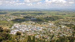
Matamata-Piako District covers 1,755.35 km2 (677.74 sq mi) [1] and had an estimated population of 37,700 as of June 2023, [2] with a population density of 21.5 people per km2. 8,960 people live in Morrinsville, 9,130 in Matamata, and 4,670 in Te Aroha.

Historical population
YearPop.±% p.a.
200630,483    
201331,536+0.49%
201834,404+1.76%
Source: [3]

Matamata-Piako District had a population of 34,404 at the 2018 New Zealand census, an increase of 2,868 people (9.1%) since the 2013 census, and an increase of 3,921 people (12.9%) since the 2006 census. There were 12,873 households, comprising 17,001 males and 17,403 females, giving a sex ratio of 0.98 males per female. The median age was 40.8 years (compared with 37.4 years nationally), with 6,999 people (20.3%) aged under 15 years, 6,186 (18.0%) aged 15 to 29, 14,436 (42.0%) aged 30 to 64, and 6,783 (19.7%) aged 65 or older.

Ethnicities were 84.4% European/Pākehā, 16.7% Māori, 2.1% Pacific peoples, 5.7% Asian, and 1.7% other ethnicities. People may identify with more than one ethnicity.

The percentage of people born overseas was 14.4, compared with 27.1% nationally.

Although some people chose not to answer the census's question about religious affiliation, 51.4% had no religion, 35.8% were Christian, 0.9% had Māori religious beliefs, 0.8% were Hindu, 0.3% were Muslim, 0.9% were Buddhist and 1.8% had other religions.

Of those at least 15 years old, 3,204 (11.7%) people had a bachelor's or higher degree, and 7,203 (26.3%) people had no formal qualifications. The median income was $32,400, compared with $31,800 nationally. 4,221 people (15.4%) earned over $70,000 compared to 17.2% nationally. The employment status of those at least 15 was that 13,566 (49.5%) people were employed full-time, 4,077 (14.9%) were part-time, and 876 (3.2%) were unemployed. [3]

Individual wards
NameArea (km2)PopulationDensity (per km2)HouseholdsMedian ageMedian income
Morrinsville Ward573.0012,50121.824,60838.6 years$35,200
Te Aroha Ward517.108,26815.993,12643.3 years$29,300
Matamata Ward665.2413,63520.505,14241.4 years$31,800
New Zealand37.4 years$31,800

Twin cities

Matamata-Piako is twinned with:

Flag of Australia (converted).svg Flag of New South Wales.svg Ballina, New South Wales, Australia [4]

Related Research Articles

<span class="mw-page-title-main">Waikato</span> Region of New Zealand

Waikato is a region of the upper North Island of New Zealand. It covers the Waikato District, Waipa District, Matamata-Piako District, South Waikato District and Hamilton City, as well as Hauraki, Coromandel Peninsula, the northern King Country, much of the Taupō District, and parts of the Rotorua Lakes District. It is governed by the Waikato Regional Council.

<span class="mw-page-title-main">Matamata</span> Town in Waikato, New Zealand

Matamata is a town in Waikato, New Zealand. It is located near the base of the Kaimai Ranges, and is a thriving farming area known for Thoroughbred horse breeding and training pursuits. It is part of the Matamata-Piako District, which takes in the surrounding rural areas, as well as Morrinsville and Te Aroha. State Highway 27 and the Kinleith Branch railway run through the town. The town has a population of 9,130 as of June 2023.

<span class="mw-page-title-main">Morrinsville</span> Town in Waikato, New Zealand

Morrinsville is a provincial town in the Waikato region of New Zealand's North Island, with an estimated population of 8,960 as of June 2023. The town is located at the northern base of the Pakaroa Range, and on the south-western fringe of the Hauraki Plains. Morrinsville is around 33 kilometres east of Hamilton and 22 kilometres west of Te Aroha. The town is bordered by the Piako River to the east and the Waitakaruru Stream to the south.

<span class="mw-page-title-main">Te Aroha</span> Town in Waikato, New Zealand

Te Aroha is a rural town in the Waikato region of New Zealand with a population of 3,906 people in the 2013 census, an increase of 138 people since 2006. It is 53 km (33 mi) northeast of Hamilton and 50 km (31 mi) south of Thames. It sits at the foot of 952 metres (3,123 ft) Mount Te Aroha, the highest point in the Kaimai Range.

<span class="mw-page-title-main">Thames-Coromandel District</span> Territorial authority district in Waikato, New Zealand

The Thames-Coromandel District is a territorial authority district in the North Island of New Zealand, covering all the Coromandel Peninsula and extending south to Hikutaia.

<span class="mw-page-title-main">Hauraki District</span> Territorial authority district in Waikato Region, New Zealand

Hauraki District is a territorial authority within the Hauraki region of New Zealand. The seat of the council is at Paeroa.

<span class="mw-page-title-main">South Waikato District</span> Territorial authority district in Waikato, New Zealand

South Waikato District is a local government district in the Waikato Region of the North Island of New Zealand. It is located between the cities of Hamilton to the north, Rotorua to the east, Taupo to the south and Ruapehu District to the west.

<span class="mw-page-title-main">Western Bay of Plenty District</span> Territorial authority district in Bay of Plenty, New Zealand

Western Bay of Plenty District is a territorial district within the Bay of Plenty Region of New Zealand. The district envelops Tauranga City by land, and includes Matakana Island, at the entrance to Tauranga Harbour.

<span class="mw-page-title-main">Pongaroa</span> Settlement in Manawatū-Whanganui, New Zealand

Pongaroa is a town in the Tararua District, in the southeast of the North Island of New Zealand, 110 kilometres southwest of Hastings and 200 kilometres northeast of Wellington. The nearest town is Pahiatua, 50 kilometres to the west. Popular Ākitio Beach is 30 kilometres to the east. The township straddles Route 52, a road between Masterton and Waipukurau.

Waharoa is a rural community in the Waikato region of New Zealand's North Island. It is located 7 km north of Matamata, and is part of the Matamata-Piako District. It is located at the junction of the Kinleith Branch railway and the East Coast Main Trunk Railway. State Highway 27 runs through the town, which is serviced by several shops and cafes and by a petrol station. Matamata Airport is just over 3 km (1.9 mi) north of Waharoa.

Kaeo is a township in the Far North District of New Zealand, located some 22 km (14 mi) northwest of Kerikeri. The town's name comes from the Māori-language name of the New Zealand freshwater mussel, which is found in nearby rivers.

<span class="mw-page-title-main">Frasertown</span> Settlement in Hawkes Bay Region, New Zealand

Frasertown is a small settlement in the northern Hawke's Bay Region of New Zealand's eastern North Island.

Waitōtara is a town in South Taranaki, New Zealand. Waverley is 10 km to the north-west, and Whanganui is 34 km to the south-east. State Highway 3 passes through it. The Waitōtara River flows past the east side of the town.

Te Karaka is a small settlement inland from Gisborne, in the northeast of New Zealand's North Island. It is located in the valley of the Waipaoa River close to its junction with its tributary, the Waihora River. Te Karaka is located on State Highway 2, and is the largest settlement between Gisborne and Ōpōtiki in the Bay of Plenty.

Waitoa is a settlement in the Matamata-Piako District of New Zealand. State Highway 26 runs through the town, and connects to Te Aroha 10 km to the north-east.

<span class="mw-page-title-main">Matapouri</span> Place in Northland Region, New Zealand

Matapouri is a coastal settlement in the Whangarei District of Northland, New Zealand. It is 7 km north of Tutukaka and 35 km north-east of Whangārei, in an area known as the Tutukaka Coast. Matapouri was described by Whangarei District Council in 2010 as "an archetypal Kiwi bach settlement". Holiday homes make up 90 per cent of the houses and at holiday times the number of residents swells to seven times its permanent population.

Waihou is a rural settlement in the Matamata-Piako District and Waikato region of New Zealand's North Island.

<span class="mw-page-title-main">Kai Iwi</span> Settlement in Manawatū-Whanganui, New Zealand

Kai Iwi is a rural community west of Whanganui in New Zealand's North Island. It lies close to SH 3, approximately halfway between Whanganui and Waitotara. The population centre is at Kai Iwi Beach, also called Mowhanau.

Springdale is a rural community in the Matamata-Piako District and Waikato region of New Zealand's North Island.

<span class="mw-page-title-main">Ruby Bay</span> Settlement in Tasman District, New Zealand

Ruby Bay is a settlement in the Tasman District of New Zealand's upper South Island. It is located between Māpua and Tasman on Te Mamaku / Ruby Bay. Ruby Bay was named after small 'rubies' found within the moutere gravel.

References

  1. 1 2 "ArcGIS Web Application". statsnz.maps.arcgis.com. Retrieved 1 March 2022.
  2. 1 2 "Subnational population estimates (RC, SA2), by age and sex, at 30 June 1996-2023 (2023 boundaries)". Statistics New Zealand . Retrieved 25 October 2023. (regional councils); "Subnational population estimates (TA, SA2), by age and sex, at 30 June 1996-2023 (2023 boundaries)". Statistics New Zealand . Retrieved 25 October 2023. (territorial authorities); "Subnational population estimates (urban rural), by age and sex, at 30 June 1996-2023 (2023 boundaries)". Statistics New Zealand . Retrieved 25 October 2023. (urban areas)
  3. 1 2 "Statistical area 1 dataset for 2018 Census". Statistics New Zealand. March 2020. Matamata-Piako District (015). 2018 Census place summary: Matamata-Piako District
  4. "Sister City Agreement". Archived from the original on 31 August 2007. Retrieved 10 July 2009.