South Wairarapa District

Last updated
South Wairarapa District
Lake Wairarapa from Remutaka Trig.jpg
South Wairarapa District Council logo.svg
South Wairarapa DC.PNG
Coordinates: 41°17′06″S175°34′44″E / 41.285°S 175.579°E / -41.285; 175.579
CountryNew Zealand
Region Wellington
Seat Martinborough
Wards
Government
   Mayor Martin Connelly
  Deputy MayorMelissa Sadler-Futter
   Territorial authority South Wairarapa District Council
Area
[1]
  Total2,387.75 km2 (921.92 sq mi)
Population
 (June 2023) [2]
  Total11,900
  Density5.0/km2 (13/sq mi)
Time zone UTC+12 (NZST)
  Summer (DST) UTC+13 (NZDT)
Postcode(s)
5710, 5711, 5712, 5740, 5741, 5742, 5771, 5772, 5773, 5781, 5782, 5783, 5784, 5794
Area code 06
Website www.swdc.govt.nz OOjs UI icon edit-ltr-progressive.svg

The South Wairarapa District is a district at the south-east tip of the North Island of New Zealand, governed by the South Wairarapa District Council. The district comprises the southernmost part of the Wairarapa, and is part of the Wellington Region.

Contents

Features

The district comprises the floodplain of the Ruamahanga River and the associated Lake Wairarapa, as well as the long southern stretch of Palliser Bay. To the west of the plains rise the eastern slopes of the Remutaka Range, the crest of which forms the western boundary of the district, while the Aorangi Range lies to the south-east. The southernmost point of the North Island, Cape Palliser, is in the South Wairarapa.

While it is predominantly rural, the South Wairarapa has three towns. The two largest towns, almost identical in population, are Greytown and Featherston. Greytown is where Arbor Day was first celebrated in New Zealand. The Fell Locomotive Museum in Featherston has a museum displaying the world's only Fell locomotive. The third-largest town and the seat of the district council is Martinborough; it is the centre of a nationally important wine-producing area.

It is expected that the number of people living in the district's urban areas will increase due to rising property prices in Wellington proper, and the proximity to transport links. [3] [4]

Demographics

South Wairarapa District covers 2,387.75 km2 (921.92 sq mi) [1] and had an estimated population of 11,900 as of June 2023, [2] with a population density of 5.0 people per km2.

Historical population
YearPop.±% p.a.
20068,892    
20139,528+0.99%
201810,575+2.11%
202311,900+2.39%
Source: [5]

South Wairarapa District had a population of 10,575 at the 2018 New Zealand census, an increase of 1,047 people (11.0%) since the 2013 census, and an increase of 1,683 people (18.9%) since the 2006 census. There were 4,335 households, comprising 5,271 males and 5,307 females, giving a sex ratio of 0.99 males per female. The median age was 47.1 years (compared with 37.4 years nationally), with 1,917 people (18.1%) aged under 15 years, 1,314 (12.4%) aged 15 to 29, 5,025 (47.5%) aged 30 to 64, and 2,319 (21.9%) aged 65 or older.

Ethnicities were 90.5% European/Pākehā, 14.2% Māori, 2.2% Pasifika, 2.5% Asian, and 1.9% other ethnicities. People may identify with more than one ethnicity.

The percentage of people born overseas was 17.2, compared with 27.1% nationally.

Although some people chose not to answer the census's question about religious affiliation, 55.6% had no religion, 33.4% were Christian, 0.7% had Māori religious beliefs, 0.3% were Hindu, 0.1% were Muslim, 0.6% were Buddhist and 1.9% had other religions.

Of those at least 15 years old, 2,070 (23.9%) people had a bachelor's or higher degree, and 1,599 (18.5%) people had no formal qualifications. The median income was $32,900, compared with $31,800 nationally. 1,710 people (19.8%) earned over $70,000 compared to 17.2% nationally. The employment status of those at least 15 was that 4,239 (49.0%) people were employed full-time, 1,446 (16.7%) were part-time, and 237 (2.7%) were unemployed. [5]

Individual wards
NameArea (km2)PopulationDensity (per km2)HouseholdsMedian ageMedian income
Greytown Ward273.303,58813.131,46750.1 years$33,800
Featherston Ward372.133,2768.801,35044.4 years$28,200
Martinborough Ward1,742.333,7112.131,51546.5 years$35,800
New Zealand37.4 years$31,800
Individual statistical areas in South Wairarapa district (2018 census) [6]
SA2 namePopulationDwellingsMedian ageMedian income
Aorangi Forest1,4641,11046.5 years$37,000
Featherston2,4871,17043.8 years$25,600
Greytown2,4661,23651.5 years$32,200
Kahutara1,03550741.1 years$41,000
Martinborough1,7671,05949.3 years$33,200
Tauherenikau1,35363347.5 years$37,200

Transport

Bank of New Zealand building in Greytown Bank of New Zealand building Greytown Wairarapa (7500135128).jpg
Bank of New Zealand building in Greytown

Because of South Wairarapa's proximity to the capital city of New Zealand, Wellington, there are close links between the two areas. For example, some people live in South Wairarapa and commute to Wellington each day to work; others live and work in Wellington while spending weekends in South Wairarapa. The Wairarapa Line, part of the Metlink public transport network for the Wellington region, passes through the district (which is served by the two stations of Featherston and Woodside) and provides a faster method of transport into the city than the Remutaka pass road. Metlink buses also provide services to Greytown and Martinborough from the railway stations and Masterton.

Local and regional government

The South Wairarapa District Council is the territorial authority responsible for the area. The council consists of nine councillors; the current mayor is Martin Connelly. [7] The three towns also have their own community boards. [8]

Related Research Articles

<span class="mw-page-title-main">North Island</span> One of the two main New Zealand islands

The North Island, also officially named Te Ika-a-Māui, is one of the two main islands of New Zealand, separated from the larger but less populous South Island by Cook Strait. With an area of 113,729 km2 (43,911 sq mi), it is the world's 14th-largest island, constituting 44% of New Zealand's land area. It has a population of 3,997,300, which is 77% of New Zealand's residents, making it the most populous island in Polynesia and the 28th-most-populous island in the world.

<span class="mw-page-title-main">Wellington Region</span> Region of New Zealand

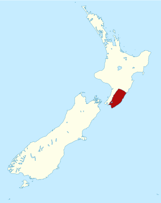
Greater Wellington, also known as the Wellington Region, is a non-unitary region of New Zealand that occupies the southernmost part of the North Island. The region covers an area of 8,049 square kilometres (3,108 sq mi), and has a population of 550,500.

<span class="mw-page-title-main">Upper Hutt</span> City in Wellington Region, New Zealand

Upper Hutt is a city in the Wellington Region of New Zealand and one of the four cities that constitute the Wellington metropolitan area.

<span class="mw-page-title-main">Wairarapa</span> Geographical region of New Zealands North Island

The Wairarapa, a geographical region of New Zealand, lies in the south-eastern corner of the North Island, east of metropolitan Wellington and south-west of the Hawke's Bay Region. It is lightly populated, having several rural service towns, with Masterton being the largest. It is named after its largest lake, Lake Wairarapa.

<span class="mw-page-title-main">Levin, New Zealand</span> Town in Manawatū-Whanganui, New Zealand

Levin is the largest town and seat of the Horowhenua District, in the Manawatū-Whanganui region of New Zealand's North Island. It is located east of Lake Horowhenua, around 95 km north of Wellington and 50 km southwest of Palmerston North.

<span class="mw-page-title-main">Carterton, New Zealand</span> Town and District in Wellington Region, New Zealand

Carterton is a small town in the Wellington Region of New Zealand and the seat of the Carterton District. It lies in a farming area of the Wairarapa in New Zealand's North Island. It is located 14 km (8.7 mi) southwest of Masterton and 80 km (50 mi) northeast of Wellington. The town has a population of 5,960, out of a total district population of 10,250.

<span class="mw-page-title-main">Masterton</span> Town in the North Island of New Zealand

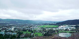
Masterton is a large town in the Greater Wellington Region of New Zealand that operates as the seat of the Masterton District. It is the largest town in the Wairarapa, a region separated from Wellington by the Rimutaka ranges. It stands on the Waipoua stream between the Ruamahunga and Waingawa Rivers – 100 kilometres north-east of Wellington and 39.4 kilometres south of Eketāhuna.

<span class="mw-page-title-main">Waipā District</span> Territorial authority district in Waikato, New Zealand

Waipa District is a municipality in the Waikato region of New Zealand that is administered by the Waipa District Council. Its most populous town is Cambridge. The seat of the council is at the second most populous town, Te Awamutu. The district is south and south-east of the city of Hamilton. It has five wards: Te Awamutu, Cambridge, Pirongia, Maungatautari and Kakepuku.

<span class="mw-page-title-main">Tararua District</span> Territorial authority district in Manawatū-Whanganui, New Zealand

The Tararua District is a district near the south-east corner of New Zealand's North Island that is administered by the Tararua District Council. It has a population of 19,200, and an area of 4,364.65 km². The Tararua District Council was created by the amalgamation of the Dannevirke Borough, Eketahuna County Council, Pahiatua Borough Council, Pahiatua County Council and Woodville District Council in the 1989 local government reforms.

<span class="mw-page-title-main">Featherston, New Zealand</span> Town in the Wellington Region, New Zealand

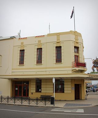
Featherston is a town in the South Wairarapa District, in the Wellington Region of New Zealand's North Island. It is at the eastern foothills of Remutaka Range close to the northern shore of Lake Wairarapa, 63 km (39 mi) north-east of central Wellington and 37 km (23 mi) south-west of Masterton.

<span class="mw-page-title-main">Martinborough</span> Town in the North Island of New Zealand

Martinborough is a town in the South Wairarapa District, in the Wellington region of New Zealand. It is 65 kilometres east of Wellington and 35 kilometres south-west of Masterton. The town has a resident population of 2,060.

<span class="mw-page-title-main">Central Hawke's Bay District</span> Territorial authority district in Hawkes Bay, New Zealand

Central Hawke's Bay District is in the Hawke's Bay Region in the North Island of New Zealand. Formed in 1989, it covers an area of 3,333 square kilometres, from Pukehou in the north to Takapau in the south, and from the western Ruahine Range to the Pacific coast in the east. It has a population of 16,000, up from 14,142 in the 2018 census and 12,717 in the 2013 census.

<span class="mw-page-title-main">Greytown, New Zealand</span> Town in the North Island of New Zealand

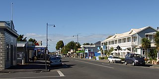
Greytown, population 2,202, is a rural town in the centre of the Wairarapa region of New Zealand, in the lower North Island. It is 80 km north-east of Wellington and 25 kilometres southwest of Masterton, on State Highway 2. It was awarded the title of New Zealand's Most Beautiful Small Town 2017.

<span class="mw-page-title-main">Pongaroa</span> Settlement in Manawatū-Whanganui, New Zealand

Pongaroa is a town in the Tararua District, in the southeast of the North Island of New Zealand, 110 kilometres southwest of Hastings and 200 kilometres northeast of Wellington. The nearest town is Pahiatua, 50 kilometres to the west. Popular Ākitio Beach is 30 kilometres to the east. The township straddles Route 52, a road between Masterton and Waipukurau.

Mangakino is a small town on the banks of the Waikato River in the North Island of New Zealand. It is located close to the hydroelectric power station at Lake Maraetai, 85 kilometres (53 mi) southeast of Hamilton. The town and its infrastructure are administered as the Mangakino Pouakani ward by the Taupō District Council.

<span class="mw-page-title-main">South Taranaki District</span> Territorial authority district in Taranaki, New Zealand

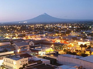
South Taranaki is a territorial authority on the west coast of New Zealand's North Island that contains the towns of Hāwera, Manaia, Ōpunake, Patea, Eltham, and Waverley. The District has a land area of 3,575.46 km2 and a population of 29,600. It is part of the greater Taranaki Region.

<span class="mw-page-title-main">Woodside railway station, Wellington Region</span> Railway station in New Zealand

Woodside railway station is a rural railway station located in the Wairarapa, 5 km west of and serving Greytown, New Zealand. The station is located on the Wairarapa Line, 65.1 km (40.5 mi) north of Wellington and 25.9 km (16.1 mi) south of Masterton. The Wairarapa Connection serves the station several times daily with services to Wellington and Masterton.

<span class="mw-page-title-main">Featherston railway station</span> Railway station in New Zealand

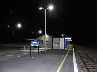
Featherston railway station is a single-platform, urban railway station serving the town of Featherston in the Wairarapa district of New Zealand. The station lies on the Wairarapa Line, and is located between Harrison Street West and Harrison Street East. It is thirty-five minutes journey time to Masterton, or fifty five minutes journey time to Wellington.

<span class="mw-page-title-main">Martinborough Branch</span>

The Martinborough Branch was a proposed railway line that would have connected the south Wairarapa town of Martinborough to the Wairarapa Line in New Zealand’s North Island. It was to have been used by passengers and by goods traffic for a productive agricultural area that was not well served with reliable transport links. Construction started, but was quickly suspended and never resumed.

The Mayor of South Wairarapa is the head of municipal government for South Wairarapa District of New Zealand, which is administered by a district council. The office has existed since the 1989 local government reforms, when the Featherston County, Greytown Borough, Featherston Borough and Martinborough Borough were amalgamated.

References

  1. 1 2 "ArcGIS Web Application". statsnz.maps.arcgis.com. Retrieved 10 March 2022.
  2. 1 2 "Subnational population estimates (RC, SA2), by age and sex, at 30 June 1996-2023 (2023 boundaries)". Statistics New Zealand . Retrieved 25 October 2023. (regional councils); "Subnational population estimates (TA, SA2), by age and sex, at 30 June 1996-2023 (2023 boundaries)". Statistics New Zealand . Retrieved 25 October 2023. (territorial authorities); "Subnational population estimates (urban rural), by age and sex, at 30 June 1996-2023 (2023 boundaries)". Statistics New Zealand . Retrieved 25 October 2023. (urban areas)
  3. Macdonald, Nikki (May 2018). "Featherston: from bleak town to boom town". Stuff.co.nz. Retrieved 23 July 2018.
  4. Fuller, Piers (15 July 2018). "High cost of Wellington living forces students into long commutes". Stuff.co.nz. Retrieved 23 July 2018.
  5. 1 2 "Statistical area 1 dataset for 2018 Census". Statistics New Zealand. March 2020. South Wairarapa District (050). 2018 Census place summary: South Wairarapa District
  6. "2018 Census place summaries | Stats NZ". www.stats.govt.nz. Retrieved 2020-12-14.
  7. "Contact a Councillor". South Wairarapa District Council. Retrieved 4 November 2019.
  8. "Council Committees and Working Parties" (PDF). South Wairarapa District Council. 22 November 2000. Retrieved 23 July 2018.