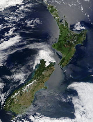
New Zealand is an island country located in the southwestern Pacific Ocean, near the centre of the water hemisphere. It consists of a large number of islands, estimated around 700, mainly remnants of a larger landmass now beneath the sea. The land masses by size are the South Island and the North Island, separated by the Cook Strait. The third-largest is Stewart Island / Rakiura, located 30 kilometres off the tip of the South Island across Foveaux Strait. Other islands are significantly smaller in area. The three largest islands stretch 1,600 kilometres across latitudes 35° to 47° south. New Zealand is the sixth-largest island country in the world, with a land size of 268,680 km2 (103,740 sq mi).

Cook Strait is a strait that separates North Island from the South Island of New Zealand. The strait connects the Tasman Sea on the northwest with the South Pacific Ocean on the southeast. It is 22 kilometres (14 mi) wide at its narrowest point, and is considered one of the most dangerous and unpredictable waters in the world. Regular ferry services run across the strait between Picton in the Marlborough Sounds and Wellington.

Neah Bay is a census-designated place (CDP) on the Makah Reservation in Clallam County, Washington, United States. The population was 935 at the 2020 census. It is across the Canada–US border from British Columbia. Europeans originally called it "Scarborough Harbour" in honor of Captain James Scarborough of the Hudson's Bay Company. It was changed to Neah in 1847 by Captain Henry Kellett. Kellett spelled it "Neeah Bay". The name "Neah" refers to the Makah Chief Dee-ah, pronounced Neah in the Klallam language. During the summer months, Neah Bay is a popular fishing area for sports fishermen. Another attraction is the Makah Museum, which houses artifacts from a Makah village partly buried by a mudslide around 1750. Many people also visit to hike the Cape Trail or camp at Hobuck Beach. An emergency response tug is stationed at Neah Bay which has saved 41 vessels since its introduction in 1999.

Whakatāne is a town located in the Bay of Plenty Region in the North Island of New Zealand, 90 kilometres (56 mi) east of Tauranga and 89 kilometres (55 mi) northeast of Rotorua. The town is situated at the mouth of the Whakatāne River. The Whakatāne District is the territorial authority that encompasses the town, covering an area to the south and west of the town, excluding the enclave of Kawerau District.

Dargaville is a town located in the North Island of New Zealand. It is situated on the bank of the Northern Wairoa River in the Kaipara District of the Northland region. Dargaville is located 55 kilometres (34 mi) southwest of Whangārei, and 174 kilometres (108 mi) north of Auckland.

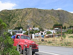
Twizel is the largest town in the Mackenzie District, in the Canterbury Region of the South Island of New Zealand. The town was founded in 1968 to house construction workers on the Upper Waitaki Hydroelectric Scheme. Today, Twizel is a service and tourist town for visitors to the area. It has a resident population of 1,890 ; during the summer, holidaymakers nearly triple the town's population.

Martinborough is a town in the South Wairarapa District, in the Wellington region of New Zealand. It is 65 kilometres east of Wellington and 35 kilometres south-west of Masterton. The town has a resident population of 2,050.

Lake Ōhau is a lake in the Mackenzie Basin in the South Island of New Zealand. The Hopkins and Dobson rivers fed into the northern end of Lake Ōhau. These rivers have their headwaters in the Southern Alps. The lake's outflow is the Ōhau River, which travels from the southeast corner of Lake Ōhau and feeds into the Waitaki River hydroelectric project. The Barrier range dominate the western side of Lake Ōhau, while the Ben Ohau range dominates the eastern side of Lake Ōhau. At the northern end of the lake, in between the Hopkins and Dobson rivers, lies the Naumann Range of mountains.

Cape Palliser is a promontory on the southern coast of New Zealand's North Island and is the southernmost point of the North Island; it is in fact considerably farther south than Nelson or Blenheim in the South Island.

Cadgwith is a village and fishing port in Cornwall, England, United Kingdom. It is on the Lizard Peninsula between The Lizard and Coverack. It is in the civil parish of Grade Ruan.
The Awhea River is a river of New Zealand. It is in the Wairarapa, close to the North Island's southernmost point, and flows south for 24 kilometres (15 mi) from rough hill country south of Martinborough to reach the Pacific 20 kilometres (12 mi) to the east of Cape Palliser.
The Rerewhakaaitu River is a river of the Wellington Region of New Zealand's North Island. It flows southeast from its sources in rough hill country southeast of Martinborough, reaching the Pacific Ocean 40 kilometres (25 mi) northeast of Cape Palliser.
Lodge Bay is a local service district and designated place in the Canadian province of Newfoundland and Labrador. It is on the southeast coast of Labrador. Encompassing a population of less than one hundred residents, the community has uniquely evolved from both early European colonization of Labrador, and the inimitable patterns of land and resource use by the migratory Inuit population. The name Lodge Bay originated from the title Ranger Lodge, which was the name given to the area by trader and explorer, Captain George Cartwright in the late 18th century. "Ranger" was the name of the wooden-mercantile ship Cartwright used to trade, map and explore the Labrador coast, while "Lodge" was the name given to English hunting camps in Great Britain at that time.
The Tūranganui River of the Wellington Region of New Zealand flows through the south Wairarapa from its source in the Aorangi Range to reach the Ruamahanga River shortly before the latter's outflow into Palliser Bay.
The following outline is provided as an overview of and topical guide to the fishing industry:

Ward Beach is a section of rugged coastline in the Marlborough Region of New Zealand that is known for unusual rock formations. The geological features include the exposed reef platforms that were uplifted by 2 m or more during the 2016 Kaikōura earthquake, and the spherical concretions known as the Ward Beach boulders. Another formation known as the Chancet Rocks is located in a scientific reserve about 1.5 km to the north of the Ward Beach roadend. They contain unusual trace fossils and provide amongst the best on-land evidence of the Cretaceous–Paleogene boundary in marine sediments in the Southern Hemisphere.
Long Island-Kokomohua Marine Reserve is a marine reserve, in the Marlborough Region of New Zealand's South Island. It covers an area of 619 hectares at the entrance to the Queen Charlotte Sound in the Marlborough Sounds. It was the first marine reserve established on the South Island.

Kahurangi Marine Reserve is a marine reserve administered by the Department of Conservation, covering 8,419 hectares offshore of Kahurangi National Park in the Buller District of New Zealand's West Coast Region.

Tāwharanui Marine Reserve is a marine reserve covering an area of 394 hectares in the Hauraki Gulf, offshore from the Tāwharanui Peninsula in the Auckland Region of New Zealand's North Island. It was established in 2011 and is administered by the Department of Conservation.
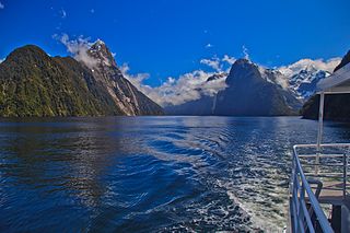
Piopiotahi Marine Reserve is a marine reserve covering an area of 690 hectares in the Milford Sound / Piopiotahi, in Fiordland on New Zealand's South Island. It was established in 1993 and is administered by the Department of Conservation.