"},"population_density_km2":{"wt":"auto"},"timezone":{"wt":"[[Time in New Zealand|NZST]]"},"utc_offset":{"wt":"+12"},"timezone_DST":{"wt":"NZDT"},"utc_offset_DST":{"wt":"+13\n"},"postal_code_type":{"wt":"[[Postcodes in New Zealand|Postcode(s)]]"},"postal_code":{"wt":"5711"},"area_code":{"wt":"06"}},"i":0}}]}" id="mwCQ">Place in Wellington Region, New Zealand
Martinborough Wharekaka (Māori) | |
---|---|
![]() Martinborough's Memorial Square | |
![]() | |
Coordinates: 41°13′8″S175°27′33″E / 41.21889°S 175.45917°E | |
Region | Wellington Region |
Territorial authority | South Wairarapa District |
Ward | Martinborough Ward |
Community | Martinborough Community [1] |
Electorates | |
Government | |
• Territorial Authority | South Wairarapa District Council |
• Regional council | Greater Wellington Regional Council |
• Mayor of South Wairarapa | Martin Connelly |
• Wairarapa MP | Mike Butterick |
• Ikaroa-Rāwhiti MP | Cushla Tangaere-Manuel |
Area | |
• Total | 4.50 km2 (1.74 sq mi) |
Population (June 2023) [3] | |
• Total | 2,060 |
• Density | 460/km2 (1,200/sq mi) |
Time zone | UTC+12 (NZST) |
• Summer (DST) | UTC+13 (NZDT) |
Postcode(s) | 5711 |
Area code | 06 |
Martinborough (Māori : Wharekaka or Māori : Huangarua) [4] is a town in the South Wairarapa District, in the Wellington region of New Zealand. It is 65 kilometres east of Wellington and 35 kilometres south-west of Masterton. The town has a resident population of 2,060 (June 2023). [3]
The town is home to the South Wairarapa District Council.
John Martin is regarded as the town’s founder and set out the first streets in the pattern of the Union Flag [5] in the 19th century. Before Martinborough was established the southern part of the region was known as Waihenga, a point that seems to be lost at times in the history of the district. A feature is the colonial architecture, one example of which is the historic Martinborough Hotel, built in 1882.
Prior to the expansion of viticulture, Martinborough was largely a rural service town for nearby farms.
The mayor of Martinborough officiated over the Martinborough Borough of New Zealand, which was administered by the Martinborough Borough Council. The office existed from 1928 until 1989, when Martinborough Borough alongside Greytown and Featherston boroughs also with Featherston County was amalgamated into the South Wairarapa District Council as part of the 1989 local government reforms.
Name | Term | |
---|---|---|
1 | W.B. Martin | 1928-1938 |
2 | C.W.F. Skill | 1938-1941 |
3 | C.R. Holmes | 1941-1946 |
4 | J. Martin | 1946–1953 |
5 | L.A. Campbell | 1953–1965 |
6 | S.H. Ussher | 1965-1973 |
7 | Dawson Wright | 1973–1989 |
The local Hau Ariki Marae and Te Whare Wananga o Tupai meeting house are affiliated with the Ngāti Kahungunu hapū of Ngāti Hikawera o Kahungunu. [6] [7]
In October 2020, the Government committed $371,332 from the Provincial Growth Fund to upgrade the marae, and create 37 jobs. [8]
Martinborough covers 4.50 km2 (1.74 sq mi) [2] and had an estimated population of 2,000 as of June 2022, [9] with a population density of 444 people per km2.
Year | Pop. | ±% p.a. |
---|---|---|
2006 | 1,329 | — |
2013 | 1,473 | +1.48% |
2018 | 1,767 | +3.71% |
Source: [10] |
Martinborough had a population of 1,767 at the 2018 New Zealand census, an increase of 294 people (20.0%) since the 2013 census, and an increase of 438 people (33.0%) since the 2006 census. There were 741 households, comprising 852 males and 915 females, giving a sex ratio of 0.93 males per female. The median age was 49.3 years (compared with 37.4 years nationally), with 288 people (16.3%) aged under 15 years, 192 (10.9%) aged 15 to 29, 840 (47.5%) aged 30 to 64, and 444 (25.1%) aged 65 or older.
Ethnicities were 84.9% European/Pākehā, 18.5% Māori, 3.6% Pasifika, 3.7% Asian, and 1.9% other ethnicities. People may identify with more than one ethnicity.
The percentage of people born overseas was 19.5, compared with 27.1% nationally.
Although some people chose not to answer the census's question about religious affiliation, 57.0% had no religion, 31.4% were Christian, 1.2% had Māori religious beliefs, 0.3% were Hindu, 0.2% were Muslim, 1.9% were Buddhist and 2.2% had other religions.
Of those at least 15 years old, 387 (26.2%) people had a bachelor's or higher degree, and 279 (18.9%) people had no formal qualifications. The median income was $33,200, compared with $31,800 nationally. 282 people (19.1%) earned over $70,000 compared to 17.2% nationally. The employment status of those at least 15 was that 723 (48.9%) people were employed full-time, 246 (16.6%) were part-time, and 30 (2.0%) were unemployed. [10]
Martinborough has a large number of vineyards producing wines, notably Pinot noir. Martinborough has a warm micro-climate, with hills to the east and west. Almost all the vineyards are in thin ribbons around the northern and eastern sides of the town, and on the Dry River to the south. All follow dry riverbeds, which provide appropriate soils for viticulture.
Notable wineries include Schubert Wines, [11] Te Kairanga, Tirohana Estate, Palliser Estate Wines, [12] Dry River, Martinborough Vineyard, [13] Murdoch James, [14] Ata Rangi, [15] Craggy Range, [16] and Escarpment. [17] During November, the region's wines are celebrated in the Toast Martinborough wine festival. This event temporarily enlarges the population by 10,000.
Other industries around Martinborough focus on traditional beef and sheep farming; growing olives, lavender and nuts; and fishing at the coast settlements of Ngawi and Cape Palliser. Tourism is an important industry for the town, and the Martinborough i-site [18] provides advice about accommodation, activities, wineries and where to eat. Several wineries and specialist tour operators offer vineyard tours, and the Martinborough Brewery is also located in town. [19]
In January 2023, an area of 3,665 square kilometres (1,415 sq mi), was certified as the Wairarapa Dark Sky Reserve by the International Dark-Sky Association. It was the second dark sky reserve to be certified in New Zealand (after the Aoraki Mackenzie International Dark Sky Reserve was recognised in 2012). The certification of the new dark sky reserve was the result of 5 years of volunteer work by the Wairarapa Dark Sky Reserve Association and local partner organisations. [20] The area covered by the reserve includes the Aorangi Forest Park, and the South Wairarapa and Carterton Districts. Martinborough was the location for the first public meeting to discuss the proposal to apply for dark sky accreditation, [21] and the town is approximately in the centre of the reserve. [22] [23] [24]
Martinborough School is a co-educational state primary school for Year 1 to 8 students, [25] [26] with a roll of 237 as of April 2023. [27]
The nearest high school is Kuranui College.
The international cooking school Le Cordon Bleu and UCOL considered establishing a campus in Martinborough by 2009. They eventually opted to open a campus in Wellington instead, disappointing locals who were hoping it would provide an economic boost to the town. [28]
The Wairarapa, a geographical region of New Zealand, lies in the south-eastern corner of the North Island, east of metropolitan Wellington and south-west of the Hawke's Bay Region. It is lightly populated, having several rural service towns, with Masterton being the largest. It is named after its largest lake, Lake Wairarapa.
Te Kūiti is a town in the north of the King Country region of the North Island of New Zealand. It lies at the junction of State Highways 3 and 30 and on the North Island Main Trunk railway, 80 kilometres (50 mi) south of Hamilton. The town promotes itself as the sheep shearing capital of the world and is host to the annual New Zealand National Shearing Championships.
The South Wairarapa District is a district at the south-east tip of the North Island of New Zealand, governed by the South Wairarapa District Council. The district comprises the southernmost part of the Wairarapa, and is part of the Wellington Region.
Tuakau is a town in the Waikato region at the foot of the Bombay Hills, formerly part of the Franklin District until 2010, when it became part of Waikato District in the North Island of New Zealand. The town serves to support local farming, and is the residence of many employees of New Zealand Steel at Glenbrook.
Tokomaru Bay is a small beachside community located on the isolated East Coast of New Zealand's North Island. It is 91 km north of Gisborne, on State Highway 35, and close to Mount Hikurangi. The district was originally known as Toka-a-Namu, which refers to the abundance of sandflies. Over the years the name was altered to Tokomaru Bay.
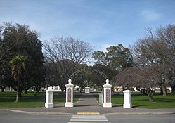
Greytown, population 2,202, is a rural town in the centre of the Wairarapa region of New Zealand, in the lower North Island. It is 80 km north-east of Wellington and 25 kilometres southwest of Masterton, on State Highway 2. It was awarded the title of New Zealand's Most Beautiful Small Town 2017.
Pongaroa is a town in the Tararua District, in the southeast of the North Island of New Zealand, 110 kilometres southwest of Hastings and 200 kilometres northeast of Wellington. The nearest town is Pahiatua, 50 kilometres to the west. Popular Ākitio Beach is 30 kilometres to the east. The township straddles Route 52, a road between Masterton and Waipukurau.
Murupara is a town in the Whakatāne District and Bay of Plenty Region of New Zealand's North Island. The town is in an isolated part of the region between the Kaingaroa Forest and Te Urewera protected area, on the banks of the Rangitaiki River, 65 kilometres southeast of Rotorua. Indigenous Māori also make up over 90% of the population.
Waihi Beach is a coastal town at the western end of the Bay of Plenty in New Zealand's North Island. It lies 10 kilometres to the east of the town of Waihi, at the foot of the Coromandel Peninsula. The main beach is 10 kilometres long. The town had a permanent population of 2,780 as of June 2023.
Tolaga Bay is both a bay and small town on the East Coast of New Zealand's North Island located 45 kilometres northeast of Gisborne and 30 kilometres south of Tokomaru Bay.
Mangakino is a small town on the banks of the Waikato River in the North Island of New Zealand. It is located close to the hydroelectric power station at Lake Maraetai, 85 kilometres (53 mi) southeast of Hamilton. The town and its infrastructure are administered as the Mangakino Pouakani ward by the Taupō District Council.
Te Kauwhata is a small town in the north of the Waikato region of New Zealand, situated close to the western shore of Lake Waikare, some 40 km north of Hamilton and approximately 58 km south of Manukau City.
Te Teko is a small inland town along the banks of the Rangitaiki River in the Bay of Plenty region of New Zealand's North Island.
Urenui is a settlement in northern Taranaki, in the North Island of New Zealand. It is located on State Highway 3 close to the shore of the North Taranaki Bight, 13 kilometres east of Waitara and 6 km south-west of Mimi. The Urenui River flows past the settlement into the North Taranaki Bight.
Nūhaka is a small settlement in the northern Hawke's Bay Region of New Zealand's eastern North Island, lying on State Highway 2 between Wairoa and Gisborne. The road to Mahia turns off the highway at Nūhaka.
Te Araroa is a town in the Gisborne Region of the North Island of New Zealand. It is situated 175 km north of Gisborne city, along State Highway 35 between Tokata and Awatere. Te Araroa is the birthplace of noted Māori politician Sir Āpirana Ngata. Māori in the area are generally associated with the Ngāti Porou iwi. It is 100 metres from its local beach.
Wairau Valley is the valley of the Wairau River in Marlborough, New Zealand and also the name of the main settlement in the upper valley. State Highway 63 runs through the valley. The valley opens onto the Wairau Plain, where Renwick and Blenheim are sited. The Alpine–Wairau Fault runs along the length of the valley.
Pātūtahi is a small settlement 15 kilometres from Gisborne, in the northeast of New Zealand's North Island. It is located in the valley of the Waipaoa River. From 1915 to 1931 Pātūtahi had a railway station on the Ngātapa Branch.
Manutūkē is a settlement in the Gisborne District of New Zealand's North Island. It is located to the west of the city of Gisborne on State Highway 2, close to the mouth of the Waipaoa River.
Pirinoa is a rural community east of Lake Wairarapa, in the South Wairarapa District and Wellington Region of New Zealand's North Island. It includes the rural settlement of Pirinoa, and the coastal settlement of Whāngaimoana.