The Wellington Region is a local-government region of New Zealand that occupies the southern end of the North Island. The region covers an area of 8,049 square kilometres (3,108 sq mi), and has a population of 542,000.
Wairarapa, a geographical region of New Zealand, lies in the south-eastern corner of the North Island, east of metropolitan Wellington and south-west of the Hawke's Bay Region. It is lightly populated, having several rural service towns, with Masterton being the largest. It is named after its largest lake, Lake Wairarapa.
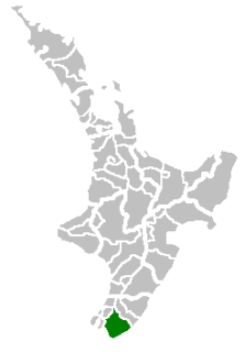
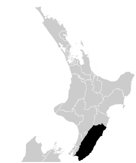
The South Wairarapa District is an area at the south-east tip of the North Island of New Zealand governed by the South Wairarapa District Council. The district comprises the southernmost part of the Wairarapa, and is part of the Wellington Region.

Carterton is a small town in the Wellington Region of New Zealand and the seat of the Carterton District. It lies in a farming area of the Wairarapa in New Zealand's North Island. It is located 14 kilometres (8.7 mi) southwest of Masterton and 80 kilometres (50 mi) northeast of Wellington. The town has a population of 5,800, out of a total district population of 9,960.

Masterton, a large town in the Greater Wellington Region of New Zealand, operates as the seat of the Masterton District. It is the largest town in the Wairarapa, a region separated from Wellington by the Rimutaka ranges. It stands on the Waipoua stream between the Ruamahunga and Waingawa Rivers - 100 kilometres north-east of Wellington and 39.4 kilometres south of Eketahuna.

The Remutaka Range is the southernmost range of a mountain chain in the lower North Island of New Zealand. The chain continues north into the Tararua, then Ruahine Ranges, running parallel with the east coast between Wellington and East Cape.

Palliser Bay is at the southern end of the North Island of New Zealand, to the southeast of Wellington. It runs for 40 kilometres along the Cook Strait coast from Turakirae Head at the southern end of the Rimutaka Ranges to Cape Palliser, the North Island's southernmost point.

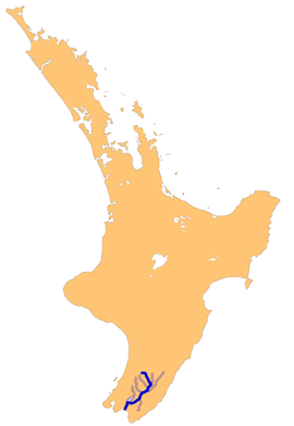
Lake Wairarapa is a lake at the southern end of the North Island of New Zealand, 50 kilometres (31 mi) east of Wellington. The lake covers an area of 78 km2 (30 sq mi), and at its deepest is 2.5 m (8.2 ft). The lake is the third largest in the North Island, fractionally smaller than Lake Rotorua. The nearest town to the lake is Featherston, which is located five kilometres from its northern shore. The lake forms part of the Wairarapa Moana Wetlands Park.

The Wairarapa Line is a secondary railway line in the south-east of the North Island of New Zealand. The line runs for 172 kilometres (107 mi), connects the capital city Wellington with the Palmerston North - Gisborne Line at Woodville, via Lower Hutt, Upper Hutt and Masterton.
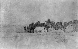
Gladstone is a lightly populated locality in the Carterton District of New Zealand's North Island, located on the Mangahuia Stream near where the Tauweru River joins the Ruamahanga River. The nearest town is Carterton 15 kilometres to the northwest, and nearby settlements include Ponatahi to the west and Longbush to the south. It was named after British prime minister William Ewart Gladstone.
The Tauweru River, sometimes called the Taueru River, is a river in the Wairarapa region of New Zealand's North Island. It drains from the pastoral eastern highlands of the Wairarapa and joins the Ruamahanga River just north of the Gladstone Road bridge into Gladstone, southeast of Carterton. The river's name is Māori for "hanging in clusters" and named after it is the town of Tauweru, located along the middle reaches of the river east of Masterton.
Te Whiti, formerly Te Whiti o Tu in the nineteenth century, is a rural community in the Wairarapa region of New Zealand's North Island. Its status has been under dispute and threatened in the twentieth century, and Land Information New Zealand acknowledges Te Whiti solely as a homestead. Its full former name means "the place of crossing" in the Māori language, reflecting its location near a natural crossing of the Ruamahanga River where it is met by the Waingawa River. The Ruamahunga River runs north and west of the locality and is also met by the Tauweru River that flows across the south of Te Whiti. In relation to major Wairarapa centres, Te Whiti is south of Masterton and east of Carterton, while nearby communities include Te Whanga to the east and Gladstone and Longbush to the south. The Maungaraki Range is also nearby.
Tauweru, alternatively Taueru, and previously known as Wardell, or Wardelltown is a locality in the Wairarapa region of New Zealand's North Island. It is named after and located on the middle reaches of the Tauweru River, which drains into the Ruamahanga River near Gladstone and Te Whiti, and the name is a Māori-language word meaning "hanging in clusters".
The Kopuaranga River is a river of the Wairarapa, in New Zealand's North Island. It flows generally south from rough hill country southwest of Eketahuna, reaching its outflow into the Ruamahanga River 5 kilometres (3 mi) north of Masterton.
The Tauanui River is a river of the South Wairarapa District of the Wellington Region of New Zealand's North Island. It flows northwest from its source in the Aorangi Range to reach the Ruamahanga River close to the southern end of Lake Wairarapa.

The Waingawa River is a river of the Greater Wellington Region of New Zealand's North Island and a major tributary of the Ruamahanga River.

The Waiohine River is a river of the Greater Wellington Region of New Zealand's North Island.
Solway is an old-established residential suburb near the Waingawa River in the south-western part of Masterton, the principal town in the Wairarapa Valley of New Zealand's North Island. It was a small part of Manaia run on which Masterton is built. It takes its present name from Solway House built in 1877 for W. H. Donald.
The Turanganui River is a river in the Wellington Region of New Zealand. It flows through the south Wairarapa from its source in the Aorangi Range to reach the Ruamahanga River shortly before the latter's outflow into Palliser Bay.