Waiohine River

Last updated

Waiohine River
Waiohine River, Waiohine Gorge, Tararua Range, New Zealand (1).JPG
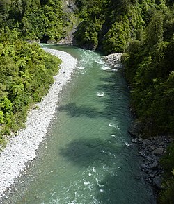
Waiohine River in Waiohine Gorge
Location
Country New Zealand
Physical characteristics
Source 
  locationLancaster Peak, Tararua Range
  elevation1,500 m (4,920 ft)
Mouth  
  location
Ruamahanga River at Pāpāwai
  elevation
40 m (130 ft)
Length35 km (22 mi)
Basin size378 km2 (146 sq mi)
Discharge 
  average25 m3/s (880 cu ft/s) at Waiohine Gorge

The Waiohine River is a river of the Greater Wellington Region of New Zealand's North Island.

At first it flows generally south from its origins in the Tararua Range west of Otaki. It turns south-east once it reaches the plain where it passes to the north of Greytown and flows into the Ruamahanga River at Pāpāwai.

Some of its water reaches Lake Wairarapa directly through many channels and irrigation features in Greytown's fruit-growing district.

See also

Related Research Articles

Wairarapa region in New Zealand

Wairarapa, is a geographical region of New Zealand. It occupies the south-eastern corner of the North Island, east of metropolitan Wellington and south-west of the Hawke's Bay region. It is lightly populated, having several rural service towns, with Masterton being the largest. It is named after its largest lake, Lake Wairarapa.

South Wairarapa District Territorial authority of New Zealand in Wellington

The South Wairarapa District is an area at the south-east tip of the North Island of New Zealand governed by the South Wairarapa District Council. The district comprises the southernmost part of the Wairarapa, and is part of the Wellington Region.

Rangitikei River river in New Zealand

The Rangitikei River is one of New Zealand's longest rivers, 185 kilometres (115 mi) long.

Ruamahanga River river in Wellington, New Zealand

The Ruamahanga River runs through the southeastern North Island of New Zealand.

Wairarapa Line

The Wairarapa Line is a secondary railway line in the south-east of the North Island of New Zealand. The line runs for 172 kilometres (107 mi), connects the capital city Wellington with the Palmerston North - Gisborne Line at Woodville, via Lower Hutt, Upper Hutt and Masterton.

Ponatahi is a community in the South Wairarapa District of New Zealand's North Island. It is located near the Ruamahanga River south-southeast of Carterton and north east of Greytown. Nearby smaller settlements include Longbush to the south and Gladstone to the east.

The Tauweru River, sometimes called the Taueru River, is a river in the Wairarapa region of New Zealand's North Island. It drains from the pastoral eastern highlands of the Wairarapa and joins the Ruamahanga River just north of the Gladstone Road bridge into Gladstone, southeast of Carterton. The river's name is Māori for "hanging in clusters" and named after it is the town of Tauweru, located along the middle reaches of the river east of Masterton.

Woodside railway station, Wellington Region railway station in New Zealand

Woodside railway station is a rural railway station located in the Wairarapa, 5 km west of and serving Greytown, New Zealand. The station is located on the Wairarapa Line, 65.1 km (40.5 mi) north of Wellington and 25.9 km (16.1 mi) south of Masterton. The Wairarapa Connection serves the station several times daily with services to Wellington and Masterton.

The Wairarapa Railway Restoration Society is a railway heritage and preservation community group in the town of Carterton, in the Wairarapa district of New Zealand's North Island. The society has leased the Carterton railway station building through the Carterton District Council, though it is owned by the New Zealand Railways Corporation.

The Awhea River is a river of New Zealand. It is in the Wairarapa, close to the North Island's southernmost point, and flows south for 24 kilometres (15 mi) from rough hill country south of Martinborough to reach the Pacific 20 kilometres (12 mi) to the east of Cape Palliser.

The Kopuaranga River is a river of the Wairarapa, in New Zealand's North Island. It flows generally south from rough hill country southwest of Eketahuna, reaching its outflow into the Ruamahanga River 5 kilometres (3 mi) north of Masterton.

The Opouawe River is a river of the Wairarapa, in the Wellington Region of New Zealand's North Island. One of the North Island's southernmost rivers, it flows generally south to reach Cook Strait close to Te Kaukau Point, 12 kilometres (7 mi) northeast of Cape Palliser

The Ruakokoputuna River is a river of the Wairarapa, in the Wellington Region of New Zealand's North Island. It flows northeast from its sources within Haurangi Forest Park to the east of Palliser Bay, reaching the Huangarua River 10 kilometres (6 mi) south of Martinborough.

The Tauanui River is a river of the South Wairarapa District of the Wellington Region of New Zealand's North Island. It flows northwest from its source in the Aorangi Range to reach the Ruamahanga River close to the southern end of Lake Wairarapa.

The Wharepapa River is a river of the Wellington Region of New Zealand's North Island. It flows south from its sources within Remutaka Forest Park to reach the western end of Palliser Bay close to the small settlement of Wharekauhau.

The Whawanui River is a river of the Wellington Region of New Zealand's North Island. It flows south from the Aorangi Range to reach Cook Strait 10 kilometres (6 mi) northeast of Cape Palliser. It is one of the southernmost rivers in the North Island.

The Makara River is a tributary of the Huangarua River, part of the Ruamahanga River system in New Zealand. It flows north from the Aorangi Range, reaching the Huangarua to the south of Martinborough.

The Rimutaka Incline railway accident occurred on 11 September 1880 when the leading three carriages on a Greytown to Wellington train were blown off the track in strong winds near the Siberia tunnel; killing four passengers. The Rimutaka Incline section of the line over the Rimutaka Ranges between Wellington and the Wairarapa used the Fell system on the steep 1 in 15 section which was 4.8 km (3.0 mi) long.

Mangatarere Stream is a small gravel-bed stream in central Wairarapa, New Zealand, that originates in the Tararua Ranges. It is located close to the township of Carterton and is the main tributary to the Waiohine River. The Waiohine flows into the Ruamahanga River, southeast of Greytown.

Michael Alexander "Mike" Hopkins was a New Zealand sound editor. Hopkins and American Ethan Van der Ryn shared two Academy Awards for best sound editing on the films The Lord of the Rings: The Two Towers and King Kong. The pair were also nominated for their work on the 2007 film Transformers.

References

Coordinates: 41°05′14″S175°30′15″E / 41.08722°S 175.50417°E / -41.08722; 175.50417