Related Research Articles

Greater Wellington, also known as the Wellington Region, is a non-unitary region of New Zealand that occupies the southernmost part of the North Island. The region covers an area of 8,049 square kilometres (3,108 sq mi), and has a population of 550,600.

The Hutt River flows through the southern North Island of New Zealand. It flows south-west from the southern Tararua Range for 56 kilometres (35 mi), forming a number of fertile floodplains, including Kaitoke, central Upper Hutt and Lower Hutt.
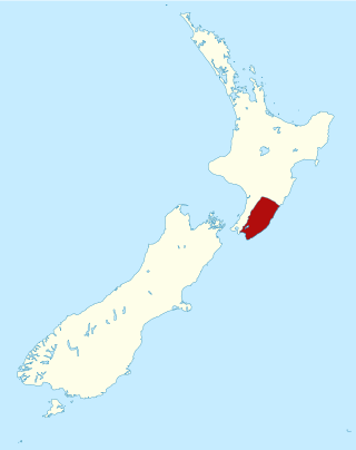
The Wairarapa, a geographical region of New Zealand, lies in the south-eastern corner of the North Island, east of metropolitan Wellington and south-west of the Hawke's Bay Region. It is lightly populated, having several rural service towns, with Masterton being the largest. It is named after its largest lake, Lake Wairarapa.

Masterton is a large town in the Greater Wellington Region of New Zealand that operates as the seat of the Masterton District. It is the largest town in the Wairarapa, a region separated from Wellington by the Remutaka ranges. It stands on the Waipoua stream between the Ruamāhunga and Waingawa Rivers – 100 kilometres north-east of Wellington and 39.4 kilometres south of Eketāhuna.

The Remutaka Range is the southernmost range of a mountain chain in the lower North Island of New Zealand. The chain continues north into the Tararua, then Ruahine Ranges, running parallel with the east coast between Wellington and East Cape.

The Ruamahanga River runs through the southeastern North Island of New Zealand.

The Wairarapa Line is a secondary railway line in the south-east of the North Island of New Zealand. The line runs for 172 kilometres (107 mi), connects the capital city Wellington with the Palmerston North - Gisborne Line at Woodville, via Lower Hutt, Upper Hutt and Masterton.
Gladstone is a lightly populated locality in the Carterton District of New Zealand's North Island, located on the Mangahuia Stream near where the Tauweru River joins the Ruamahanga River. The nearest town is Carterton 15 kilometres to the northwest, and nearby settlements include Ponatahi to the west and Longbush to the south. It was named after British prime minister William Ewart Gladstone.
Ponatahi is a community in the South Wairarapa District of New Zealand's North Island. It is located near the Ruamahanga River south-southeast of Carterton and north east of Greytown. Nearby smaller settlements include Longbush to the south and Gladstone to the east.
Te Whiti, formerly Te Whiti o Tu in the nineteenth century, is a rural community in the Wairarapa region of New Zealand's North Island. Its status has been under dispute and threatened in the twentieth century, and Land Information New Zealand acknowledges Te Whiti solely as a homestead. Its full former name means "the place of crossing" in the Māori language, reflecting its location near a natural crossing of the Ruamahanga River where it is met by the Waingawa River. The Ruamahunga River runs north and west of the locality and is also met by the Tauweru River that flows across the south of Te Whiti. In relation to major Wairarapa centres, Te Whiti is south of Masterton and east of Carterton, while nearby communities include Te Whanga to the east and Gladstone and Longbush to the south. The Maungaraki Range is also nearby.
Tauweru, alternatively Taueru, and previously known as Wardell, or Wardelltown is a locality in the Wairarapa region of New Zealand's North Island. It is named after and located on the middle reaches of the Tauweru River, which drains into the Ruamahanga River near Gladstone and Te Whiti, and the name is a Māori-language word meaning "hanging in clusters".

The Mangatainoka River flows in the Tararua District of New Zealand's North Island. Its water was considered so pure a brewery, now the well-known Tui Brewery, was established there.
The Kopuaranga River is a river of the Wairarapa, in New Zealand's North Island. It flows generally south from rough hill country southwest of Eketāhuna, reaching its outflow into the Ruamahanga River 5 kilometres (3 mi) north of Masterton.
The Tauanui River is a river of the South Wairarapa District of the Wellington Region of New Zealand's North Island. It flows northwest from its source in the Aorangi Range to reach the Ruamahanga River close to the southern end of Lake Wairarapa.

The Waingawa River is a river of the Greater Wellington Region of New Zealand's North Island and a major tributary of the Ruamahanga River.

The Waiohine River is a river of the Greater Wellington Region of New Zealand's North Island.
The Tūranganui River of the Wellington Region of New Zealand flows through the south Wairarapa from its source in the Aorangi Range to reach the Ruamahanga River shortly before the latter's outflow into Palliser Bay.
Mangātarere Stream is a small gravel-bed stream in central Wairarapa, New Zealand, that originates in the Tararua Ranges. It is located close to the township of Carterton and is the main tributary to the Waiohine River. The Waiohine flows into the Ruamāhanga River, southeast of Greytown.
Two 1942 Wairarapa earthquakes shook the lower North Island of New Zealand on 24 June and 2 August. They were large and shallow with epicentres close together east of Masterton in the Wairarapa region. The June earthquake was sometimes referred to as the Masterton earthquake but both caused damage over a wide area, from Dannevirke and Eketāhuna over to Whanganui and down to Ōtaki and Wellington. There was one death in Wellington, on 24 June.

The Mangatainoka railway station on the Wairarapa Line was located in the Tararua District of the Manawatū-Whanganui region in New Zealand’s North Island. Located between the stations of Pahiatua and Ngawapurua, it served the farming settlement of Mangatainoka and surrounding districts.
References
- ↑ 1966 Encyclopaedia Of New Zealand: Ruamahanga River
- ↑ Map depicting the Gladstone Road bridge just south of the confluence of the Ruamahanga and Tauweru Rivers
- ↑ Sharpe, Marty, 6 July 2002, "Tauweru Spelling Stays a Hot Issue" Archived 2007-08-15 at archive.today , Wairarapa Times-Age.
- ↑ Heather, B. D., September 1973, "The Black-Fronted Dotterel (Charadrius Melanops) in the Wairarapa" Archived 2007-10-29 at the Wayback Machine , Notornis: Journal of the Ornithological Society of New Zealand 20(3), pg. 252.
- ↑ Transpower Grants - Mid-Tauweru Landcare Group
- ↑ Fish and Game New Zealand: Wellington - Fishing - Access Archived 2007-09-28 at the Wayback Machine
41°04′05″S175°38′01″E / 41.0681°S 175.6337°E