Related Research Articles
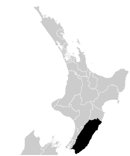
Wairarapa, a geographical region of New Zealand, lies in the south-eastern corner of the North Island, east of metropolitan Wellington and south-west of the Hawke's Bay region. It is lightly populated, having several rural service towns, with Masterton being the largest. It is named after its largest lake, Lake Wairarapa.

Carterton is a small town in the Wellington Region of New Zealand and the seat of the Carterton District. It lies in a farming area of the Wairarapa in New Zealand's North Island. It is located 14 kilometres (8.7 mi) southwest of Masterton and 80 kilometres (50 mi) northeast of Wellington. The town has a population of 5,800, out of a total district population of 9,960.

Masterton, a large town in the Greater Wellington Region of New Zealand, operates as the seat of the Masterton District. It is the largest town in the Wairarapa, a region separated from Wellington by the Rimutaka ranges. It stands on the Ruamahanga River - 100 kilometres north-east of Wellington and 39.4 kilometres south of Eketahuna.

Featherston is a town in the South Wairarapa District, in the Wellington Region of New Zealand's North Island. It is at the eastern foothills of Remutaka Range close to the northern shore of Lake Wairarapa, 63 km (39 mi) north-east of central Wellington and 37 km (23 mi) south-west of Masterton.

The Ruamahanga River runs through the southeastern North Island of New Zealand.
The Tauweru River, sometimes called the Taueru River, is a river in the Wairarapa region of New Zealand's North Island. It drains from the pastoral eastern highlands of the Wairarapa and joins the Ruamahanga River just north of the Gladstone Road bridge into Gladstone, southeast of Carterton. The river's name is Māori for "hanging in clusters" and named after it is the town of Tauweru, located along the middle reaches of the river east of Masterton.
Te Whiti, formerly Te Whiti o Tu in the nineteenth century, is a rural community in the Wairarapa region of New Zealand's North Island. Its status has been under dispute and threatened in the twentieth century, and Land Information New Zealand acknowledges Te Whiti solely as a homestead. Its full former name means "the place of crossing" in the Māori language, reflecting its location near a natural crossing of the Ruamahanga River where it is met by the Waingawa River. The Ruamahunga River runs north and west of the locality and is also met by the Tauweru River that flows across the south of Te Whiti. In relation to major Wairarapa centres, Te Whiti is south of Masterton and east of Carterton, while nearby communities include Te Whanga to the east and Gladstone and Longbush to the south. The Maungaraki Range is also nearby.

Mangatainoka is a small settlement in the Tararua District of New Zealand's North Island. It is located on the banks of the Mangatainoka River, 5 km (3.1 mi) north of Pahiatua.
Wairarapa College is a state coeducational secondary school located in Masterton, New Zealand. The college first opened in 1938, following the merger of Wairarapa High School with the Masterton Technical School. Serving Years 9 to 13, the college has 1088 students as of November 2020, including approximately 175 resident in the school's on-site boarding hostel, College House.
The Kopuaranga River is a river of the Wairarapa, in New Zealand's North Island. It flows generally south from rough hill country southwest of Eketahuna, reaching its outflow into the Ruamahanga River 5 kilometres (3 mi) north of Masterton.

The Waingawa River is a river of the Greater Wellington Region of New Zealand's North Island and a major tributary of the Ruamahanga River.
The Wellington Region of New Zealand has a foundation of Torlesse Greywacke rocks, that make up the Tararua and Rimutaka Ranges, that go from Wellington in the south to the Manawatu Gorge, where they are renamed as the Ruahine Ranges, and continue further north-northeast, towards East Cape. To the west of the Tararua Ranges are the Manawatu coastal plains. To the east of the Ruahine Ranges is the Wairarapa-Masterton Basin, then the Eastern Uplands that border the eastern coast of the North Island from Cape Palliser to Napier.

Lansdowne, Masterton's largest suburb, is on the left bank of the Waipoua stream at the north-western end of Masterton, New Zealand. On the town's highest ground it provides broad vistas of much of the Wairarapa Valley. It is further distinguished from the rest of the town by having been subdivided late in the 19th century and because it was administered by the Masterton County Council. It was amalgamated with Masterton Borough in 1921.
Solway is a suburb in the southern part of Masterton, a town in the Wairarapa Valley of New Zealand's North Island.
Queen Elizabeth Park is a cricket ground in Masterton, Wellington, New Zealand. It was named Masterton Park Oval until 1954, when the park was renamed in honour of Queen Elizabeth II after her visit to Masterton.

The 1904 Cape Turnagain earthquake struck 10 kilometres (6.2 mi) north of Cape Turnagain on the morning of 9 August with a magnitude estimated at 6.8 Ms and 7.0–7.2 Mw It was felt throughout the North Island and upper South Island, with many communities within a 500 kilometres (310 mi) radius reporting noticeable ground shaking. Heavy damage occurred to the landscape and personal property and one man died. It was the largest to strike New Zealand since the 7.0 Mw North Canterbury earthquake in 1888.
Two 1942 Wairarapa earthquakes shook the lower North Island of New Zealand; on 24 June and 2 August. They were large and shallow with the epicentres close together east of Masterton in the Wairarapa region. The June earthquake was sometimes referred to as the Masterton earthquake but both caused damage over a wide area, from Dannevirke and Eketahuna over to Whanganui and down to Otaki and Wellington. There was one death in Wellington, on 24 June.

The Wairarapa District Health Board is a district health board with the focus on providing healthcare to the Masterton, Carterton, and South Wairarapa districts of New Zealand.
Masterton Central is a suburb of Masterton, a town on New Zealand's North Island.
Masterton East is a suburb of Masterton, a town on New Zealand's North Island.
References
- 1 2 Sharpe, Marty, 6 July 2002, "Tauweru Spelling Stays a Hot Issue" Archived 2007-08-15 at Archive.today , Wairarapa Times-Age.
- ↑ Results of the New Zealand Census, 28 March 1886, "Results of a Census of the Colony of New Zealand"
- ↑ "Place name detail: Tauweru". New Zealand Gazetteer. New Zealand Geographic Board . Retrieved 25 January 2009.
- ↑ Map showing Tauweru's location
- ↑ Masterton District Library and Wairarapa Archive: A Night of Terror - the 1942 Earthquake
| Authority control |
|
|---|
Coordinates: 40°58′S175°48′E / 40.967°S 175.800°E
| | This Wellington Region-related geography article is a stub. You can help Wikipedia by expanding it. |