Mauriceville, New Zealand

Last updated • 2 min readFrom Wikipedia, The Free Encyclopedia
Mauriceville
Locality
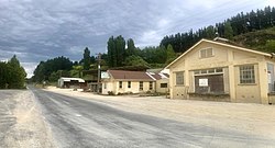
Mauriceville Dairy and Hatuma lime works office.jpg
Mauriceville Dairy and Hatuma lime works office
Coordinates: 40°46′37″S175°42′04″E / 40.777°S 175.701°E / -40.777; 175.701
Country New Zealand
Region Wellington Region
Territorial authority Masterton District

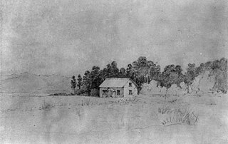
Mauriceville is a rural locality in the Masterton district, part of the Wairarapa region of New Zealand's North Island. The area is about half-way between Masterton and Eketāhuna, and is today split between Mauriceville East (on the Ōpaki-Kaiparoro Road) and Mauriceville West (nearer to Mount Bruce).

Contents

History

Mauriceville was named after Maurice O'Rorke, [1] a contemporary New Zealand politician who was Minister of Immigration and Crown Lands when the village was first founded, and was actually present when the site for the township was chosen. [2]

The area was first settled in 1872, [3] as the Scandinavian workers brought in to clear the Seventy-Mile Bush began to move north from Kōpuaranga, these workers were mostly mixed Danish, Norwegian and Swedish families, and were seen as Model Colonists. By 1897, the area's main industries were dairy farming and lime burning, and there were two schools, a railway station, two post/telegraph office, a Lutheran Church, several clubs and a public hall. [4]

The distinctly Scandinavian character of the settlement can be seen through the names of the early inhabitants. The surnames present in the 1875 Wise's Directory entries for Mauriceville (then split into North, South and West) are Halburg, Hansen, Jorgensen, Larsen, Peterson, Thomsen, Ammundsen, Andersen, Anlin, Bosen, Christiansen, Ericsen, Jespersen, Jespersen, Larsen, Larsen, Neilsen, Olsen, Swenson, Allburg, Brodersen, Christensen, Christensen, Christian, Cullen, Dorset, Forgensen, Gundersen, Hansen, Jacobsen, Jensen, Larsen, Larsen, Larsen, Neilsen, Neilsen, Neilsen, Pedersen, Dobblestein, Jensen, Jensen, Jensen, Johannesen, Lauristen, Mortensen, Olsten, Pedersen, Pedersen and Roigaard, only a few of which are not of Scandinavian origin.

Like other Scandinavian townships of the Seventy-Mile Bush, such as Dannevirke, Norsewood, Eketāhuna and Kōpuaranga, this population soon diversified, and the Scandinavian settlers quickly assimilated into the Anglo-Saxon population, marrying the English and Scots settlers and fighting by their side in the World Wars. [5] They were even considered by some to be more assimilated than New Zealanders of Southern Irish descent. [6]
Education

Mauriceville School is a co-educational state primary school for Year 1 to 8 students, [7] with a roll of 15 as of April 2023. [8]

See also

Related Research Articles

<span class="mw-page-title-main">Eastbourne, New Zealand</span> Suburb of Lower Hutt, New Zealand

Eastbourne is a suburb of Lower Hutt, a part of Wellington, New Zealand. Lying beside the sea, it is a popular local tourist destination via car from Petone or from ferry crossings from central Wellington. An outer suburb, it lies on the eastern shore of Wellington Harbour, five kilometres south of the main Lower Hutt urban area and directly across the harbour from the Miramar Peninsula in Wellington city. A narrow exposed coastal road connects it with the rest of Lower Hutt via the Eastern Bays and the industrial suburb of Seaview. It is named for Eastbourne in England, another seaside town known as a destination for day-trips.

<span class="mw-page-title-main">Dannevirke</span> Town in Manawatū-Whanganui, New Zealand

Dannevirke, is a rural service town in the Manawatū-Whanganui region of the North Island, New Zealand. It is the major town of the administrative of the Tararua District, the easternmost of the districts of which the Horizons Regional Council has responsibilities.

<span class="mw-page-title-main">Pahiatua</span> Town in Manawatū-Whanganui, New Zealand

Pahiatua is a rural service town in the south-eastern North Island of New Zealand with a population of 2,810. It is between Masterton and Woodville on State Highway 2 and along the Wairarapa Line railway, 60 kilometres (37 mi) north of Masterton and 30 kilometres (19 mi) east of Palmerston North. It is usually regarded as being in the Northern Wairarapa. For local government purposes, since 1989 it has been in the Tararua District, which encompasses Eketāhuna, Pahiatua, Woodvillle, Dannevirke, Norsewood and the far east of the Manawatū-Whanganui region.

<span class="mw-page-title-main">Eketāhuna</span> Town in Manawatū-Whanganui, New Zealand

Eketāhuna is a small rural settlement, in the south of the Tararua District and the Manawatū-Whanganui region of New Zealand's North Island.

<span class="mw-page-title-main">Masterton</span> Town in the North Island of New Zealand

Masterton is a large town in the Greater Wellington Region of New Zealand that operates as the seat of the Masterton District. It is the largest town in the Wairarapa, a region separated from Wellington by the Rimutaka ranges. It stands on the Waipoua stream between the Ruamahunga and Waingawa Rivers – 100 kilometres north-east of Wellington and 39.4 kilometres south of Eketāhuna.

<span class="mw-page-title-main">Featherston, New Zealand</span> Town in the Wellington Region, New Zealand

Featherston is a town in the South Wairarapa District, in the Wellington Region of New Zealand's North Island. It is at the eastern foothills of Remutaka Range close to the northern shore of Lake Wairarapa, 63 km (39 mi) north-east of central Wellington and 37 km (23 mi) south-west of Masterton.

<span class="mw-page-title-main">Kauri gum</span> Resin

Kauri gum is resin from kauri trees, which historically had several important industrial uses. It can also be used to make crafts such as jewellery. Kauri forests once covered much of the North Island of New Zealand, before climate change caused the forests to retreat, causing several areas to revert to sand dunes, scrubs, and swamps. Even afterwards, ancient kauri fields and the remaining forests continued to provide a source for the gum. Between 1820 and 1900, over 90% of Kauri forests were logged or burnt by Europeans.

<span class="mw-page-title-main">Pukaha / Mount Bruce National Wildlife Centre</span> Captive breeding facility and visitor centre located in a protected nature area

Pūkaha / Mount Bruce National Wildlife Centre is a captive breeding facility and visitor centre located in a protected forest area on State Highway 2 in New Zealand's Tararua district.

Te Rehunga is a rural locality located in the Tararua District, part of the Manawatu Whanganui Region of New Zealand.

<span class="mw-page-title-main">Newman railway station</span> Defunct railway station in New Zealand

Newman railway station was a station on the Wairarapa Line in the Tararua District area of the Manawatū-Whanganui region of New Zealand’s North Island. It served the small rural community of Newman, 3 kilometres (1.9 mi) north of Eketāhuna. It is accessed via Cliff Road, but is now located on private property.

<span class="mw-page-title-main">French New Zealanders</span>

French New Zealanders are New Zealanders who are of French ancestors or a French-born person who resides in New Zealand.

<span class="mw-page-title-main">Seventy Mile Bush</span>

The Seventy Mile Bush was a heavily forested area of New Zealand extending from Wairarapa to Central Hawkes Bay and out to that coast. It was cleared and settled by Scandinavians, assisted immigrants in the 1870s. On arrival they walked from the surrounding coastal settlements to cut down the forest and clear the land for farming. The land was not as described to them. Without funds for a return passage they were obliged to remain.

<span class="mw-page-title-main">Solway, New Zealand</span> Suburb of Masterton, New Zealand

Solway is an old-established residential suburb near the Waingawa River in the south-western part of Masterton, the principal town in the Wairarapa Valley of New Zealand's North Island. It was a small part of Manaia run on which Masterton is built. It takes its present name from Solway House built in 1877 for W. H. Donald.

<span class="mw-page-title-main">Mauriceville railway station</span> Defunct railway station in New Zealand

Mauriceville railway station was a rural railway station that served the small village of Mauriceville in the Wairarapa region of New Zealand’s North Island. It was located on the Wairarapa Line between the stations of Kopuaranga and Mangamahoe with direct vehicular access from Opaki Kaiparoro Road.

George Conrad Petersen was a New Zealand lawyer, consul, local politician and historian.

Japanese New Zealanders are New Zealand citizens of Japanese ancestry, which may include Japanese immigrants and descendants born in New Zealand. Japanese people first began immigrating to New Zealand in the 1890s. Until 1920, 14 Japanese citizens resided in New Zealand. Japanese immigration was halted during the period of the Pacific War and recommenced around the 1950s. From this period onwards, Japanese immigration remained small until the 1990s. In 1997, Japanese peoples were the 19th-largest ethnic group in New Zealand. As of the 2018 census, 18,141 New Zealand residents identify themselves as Japanese New Zealanders.

Danish New Zealanders are New Zealanders with full or partial Danish ancestry. The majority of these people are part of the Danish diaspora.

<span class="mw-page-title-main">Kōpuaranga</span> Rural locality in Wellington Region, New Zealand

Kōpuaranga, previously called Dreyerton, is a rural locality. in the Wairarapa region of New Zealand's North Island, between Masterton and Mauriceville.

Ōpaki is small rural settlement in the Masterton District and Wellington Region of New Zealand's North Island.

References

  1. "Encyclopedia of New Zealand 1966 - Eketahuna". teara.govt.nz.
  2. "The Otago Daily Times, 6th June 1873". paperspast.natlib.govt.nz.
  3. "Encyclopedia of New Zealand 1966 - Eketahuna". teara.govt.nz.
  4. "Cyclopedia of New Zealand". nzetc.victoria.ac.nz.
  5. "Encyclopedia of New Zealand 1966 - Scandinavians". teara.govt.nz.
  6. "Encyclopedia of New Zealand 1966 - Irish". teara.govt.nz.
  7. "Mauriceville School Ministry of Education School Profile". educationcounts.govt.nz. Ministry of Education.
  8. "Mauriceville School Education Review Office Report". ero.govt.nz. Education Review Office.