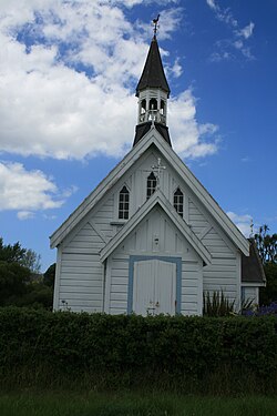
Whareama

Last updated

Whareama is a rural area in the Wellington Region of New Zealand's North Island. The Whareama River flows through the area. [1]

Contents

Marae

The community has two marae affiliated with the Ngāti Kahungunu hapū of Ngāi Tumapuhia-a-Rangi: Motuwairaka Marae, which lost its meeting house to fire in 2017, and Ngāi Tumapuhia a Rangi ki Okautete Marae, which is still constructing its meeting house by 2020. [2] [3]

In October 2020, the Government committed $2,179,654 from the Provincial Growth Fund to upgrade both marae, alongside Pāpāwai, Kohunui, Hurunui o Rangi and Te Oreore marae. Together, the upgrades were expected to create 19.8 full time jobs. [4]

Education

Whareama School is a co-educational state primary school for Year 1 to 8 students, [5] [6] with a roll of 50 as of March 2020. [7]

Related Research Articles

Tokomaru Bay Settlement in Gisborne District

Tokomaru Bay is a small beachside community located on the isolated East Coast of New Zealand's North Island. It is 91 km north of Gisborne, on State Highway 35, and close to Mount Hikurangi. The district was originally known as Toka-a-Namu, which refers to the abundance of sandflies. Over the years the name was altered to Tokomaru Bay.

Tikokino Town in New Zealand

Tikokino is a town in the Central Hawke's Bay District on the east coast of the North Island of New Zealand. It is located 20 kilometres (12 mi) northwest of Waipawa and 55 kilometres (34 mi) southwest of Hastings. The township is located on State Highway 50.

Matakana Island

Matakana Island is located in the western Bay of Plenty in New Zealand's North Island. A long, flat barrier island, it is 20 kilometres (12 mi) in length but rarely more than 3 kilometres (1.9 mi) wide. The island has been continuously populated for centuries by Māori tribes that are mostly associated with Ngāi Te Rangi.

Murupara Minor urban area in Bay of Plenty, New Zealand

Murupara is a town located in the Whakatane District and Bay of Plenty Region of New Zealand's North Island. The town is situated in an isolated part of the region between the Kaingaroa Forest and Te Urewera National Park, on the banks of the Rangitaiki River, 65 kilometres southeast of Rotorua.

Waihi Beach Place in Bay of Plenty, New Zealand

Waihi Beach is a coastal town at the western end of the Bay of Plenty in New Zealand's North Island. It lies 10 kilometres to the east of the town of Waihi, at the foot of the Coromandel Peninsula. The main beach itself extends approximately 10 kilometres. The town had a permanent population of 2,720 as of June 2020.

Ruatahuna Place in Bay of Plenty, New Zealand

Ruatahuna is a town in the northeast of New Zealand's North Island, 90 kilometres west of Gisborne, and 18 kilometres northwest of Lake Waikaremoana. It is situated on the unsealed part of SH38, from Wai-O-Tapu via Murupara to Wairoa.

Maketu Town in Bay of Plenty, New Zealand

Maketu is a small town on the Bay of Plenty Coast in New Zealand.

Te Teko Place in Bay of Plenty, New Zealand

Te Teko is a small inland town in the Bay of Plenty region of New Zealand's North Island. According to the 2013 New Zealand census, Te Teko has a population of 489, a decrease of 138 people since the 2006 census.

Nuhaka Place in New Zealand

Nuhaka is a small settlement in the northern Hawke's Bay Region of New Zealand's eastern North Island, lying on State Highway 2 between Wairoa and Gisborne.

Te Araroa

Te Araroa is a town in the Gisborne Region of the North Island of New Zealand. It is situated 175 km north of Gisborne city, along State Highway 35 between Tokata and Awatere. Te Araroa is the birthplace of noted Māori politician Sir Āpirana Ngata. Māori in the area are generally associated with the Ngāti Porou iwi. It is 100 metres from its local beach.

Rangitukia is a small settlement 10 kilometres south of East Cape in the northeast of New Zealand's North Island. It is located close to the mouth of the Waiapu River.

Manutuke is a settlement in the Gisborne District of New Zealand's North Island. It is located to the west of the city of Gisborne on State Highway 2, close to the mouth of the Waipaoa River.

Waimana Rural community in Bay of Plenty, New Zealand

Waimana is a rural valley in the Whakatane District and Bay of Plenty Region of New Zealand's North Island. It is located in the northern Urewera. Waimana River, originally known as Tauranga River, runs through the valley, joining the Ohinemataroa River one kilometre south-west of the Tāneatua.

Pirinoa Place in Wellington, New Zealand

Pirinoa is a rural community east of Lake Wairarapa, in the South Wairarapa District and Wellington Region of New Zealand's North Island. It includes the rural settlement of Pirinoa, and the coastal settlement of Whāngaimoana.

Puketapu is a rural community in the Hastings District and Hawke's Bay Region of New Zealand's North Island.

Puketapu is a rural community in the Hastings District and Hawke's Bay Region of New Zealand's North Island.

Pakipaki is a village and rural community in the Hastings District and Hawke's Bay Region of New Zealand's North Island.

Rotoiti Forest or Rotoiti is a settlement on the southern shore of the Lake Rotorua, in Rotorua Lakes within the Bay of Plenty Region of New Zealand's North Island.

Ōwhata is a semi-rural suburb of Rotorua in the Bay of Plenty region of New Zealand's North Island.

Omahu is a village in the Hastings District and Hawke's Bay Region of New Zealand's North Island.

References

  1. "Place name detail: Whareama". New Zealand Gazetteer. Land Information New Zealand . Retrieved 12 July 2009.
  2. "Te Kāhui Māngai directory". tkm.govt.nz. Te Puni Kōkiri.
  3. "Māori Maps". maorimaps.com. Te Potiki National Trust.
  4. "Marae Announcements" (Excel). growregions.govt.nz. Provincial Growth Fund. 9 October 2020.
  5. "Whareama School Official School Website". whareama.school.nz.
  6. "Whareama School Ministry of Education School Profile". educationcounts.govt.nz. Ministry of Education.
  7. "Whareama School Education Review Office Report". ero.govt.nz. Education Review Office.

Coordinates: 41°02′S176°06′E / 41.033°S 176.100°E / -41.033; 176.100