Related Research Articles
The Wairarapa, a geographical region of New Zealand, lies in the south-eastern corner of the North Island, east of metropolitan Wellington and south-west of the Hawke's Bay Region. It is lightly populated, having several rural service towns, with Masterton being the largest. It is named after its largest lake, Lake Wairarapa.
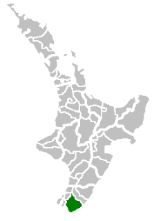
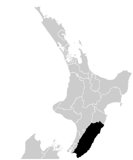
The South Wairarapa District is an area at the south-east tip of the North Island of New Zealand governed by the South Wairarapa District Council. The district comprises the southernmost part of the Wairarapa, and is part of the Wellington Region.

Carterton is a small town in the Wellington Region of New Zealand and the seat of the Carterton District. It lies in a farming area of the Wairarapa in New Zealand's North Island. It is located 14 km (8.7 mi) southwest of Masterton and 80 km (50 mi) northeast of Wellington. The town has a population of 5,850, out of a total district population of 10,050.

Masterton, a large town in the Greater Wellington Region of New Zealand, operates as the seat of the Masterton District. It is the largest town in the Wairarapa, a region separated from Wellington by the Rimutaka ranges. It stands on the Waipoua stream between the Ruamahunga and Waingawa Rivers - 100 kilometres north-east of Wellington and 39.4 kilometres south of Eketahuna.
Greytown, population 2,202, is a rural town in the centre of the Wairarapa region of New Zealand, in the lower North Island. It is 80 km north-east of Wellington and 25 kilometres southwest of Masterton, on State Highway 2. It was awarded the title of New Zealand's Most Beautiful Small Town 2017.

Palliser Bay is at the southern end of the North Island of New Zealand, to the southeast of Wellington. It runs for 40 kilometres along the Cook Strait coast from Turakirae Head at the southern end of the Rimutaka Ranges to Cape Palliser, the North Island's southernmost point. The coastline is exposed to the weather and winds.

The Ruamahanga River runs through the southeastern North Island of New Zealand.

The Universal College of Learning (UCOL) is a New Zealand Government ITP located primarily in Palmerston North but has campuses also in Whanganui, Masterton and Levin. Dr Linda Sissons is the current Chief Executive.
Wellington Regional Council, branded as Greater Wellington Regional Council, is the regional council overseeing the Wellington Region of New Zealand's lower North Island. It is responsible for public transport under the brand Metlink, environmental and flood protection, and the region's water supply.

Pūkaha / Mount Bruce National Wildlife Centre is a captive breeding facility and visitor centre located in a protected forest area on State Highway 2 in New Zealand's Tararua district.
Gladstone is a lightly populated locality in the Carterton District of New Zealand's North Island, located on the Mangahuia Stream near where the Tauweru River joins the Ruamahanga River. The nearest town is Carterton 15 kilometres to the northwest, and nearby settlements include Ponatahi to the west and Longbush to the south. It was named after British prime minister William Ewart Gladstone.
Ponatahi is a community in the South Wairarapa District of New Zealand's North Island. It is located near the Ruamahanga River south-southeast of Carterton and north east of Greytown. Nearby smaller settlements include Longbush to the south and Gladstone to the east.
The Tauweru River, sometimes called the Taueru River, is a river in the Wairarapa region of New Zealand's North Island. It drains from the pastoral eastern highlands of the Wairarapa and joins the Ruamahanga River just north of the Gladstone Road bridge into Gladstone, southeast of Carterton. The river's name is Māori for "hanging in clusters" and named after it is the town of Tauweru, located along the middle reaches of the river east of Masterton.
Tauweru, alternatively Taueru, and previously known as Wardell, or Wardelltown is a locality in the Wairarapa region of New Zealand's North Island. It is named after and located on the middle reaches of the Tauweru River, which drains into the Ruamahanga River near Gladstone and Te Whiti, and the name is a Māori-language word meaning "hanging in clusters".
Wairarapa College is a state coeducational secondary school located in Masterton, New Zealand. The college first opened in 1938, following the merger of Wairarapa High School with the Masterton Technical School. Serving Years 9 to 13, the college has 1034 students as of July 2022, including approximately 175 resident in the school's on-site boarding hostel, College House.
The Kopuaranga River is a river of the Wairarapa, in New Zealand's North Island. It flows generally south from rough hill country southwest of Eketahuna, reaching its outflow into the Ruamahanga River 5 kilometres (3 mi) north of Masterton.
The Pahaoa River is a river of the Wairarapa, in the Wellington Region of New Zealand's North Island. It winds through rough hill country to the southwest of Masterton, initially flowing southwest before turning southeast to reach the Pacific Ocean 25 kilometres (16 mi) southeast of Martinborough.

The Waingawa River is a river of the Greater Wellington Region of New Zealand's North Island and a major tributary of the Ruamahanga River.
Two 1942 Wairarapa earthquakes shook the lower North Island of New Zealand; on 24 June and 2 August. They were large and shallow with epicentres close together east of Masterton in the Wairarapa region. The June earthquake was sometimes referred to as the Masterton earthquake but both caused damage over a wide area, from Dannevirke and Eketahuna over to Whanganui and down to Otaki and Wellington. There was one death in Wellington, on 24 June.
Waitohiariki Quayle is a Māori Anglican bishop. She was ordained as Bishop of Upoko o Te Ika in the Te Pīhopatanga o Aotearoa at Rathkeale College on Thursday, September 12, 2019, where she also received a Haka greeting from her community. This makes her the first female Māori bishop in the Anglican Church, and the first woman born in New Zealand to become a bishop in the Anglican Communion. Her primary cares are housing, health needs, and youth suicide risk and empowerment.
References
- ↑ Barlow, Hugh, 2 September 2000, "Te Whiti and Proud of It" Archived 2008-10-14 at the Wayback Machine , Wairarapa Times-Age
- ↑ "Place name detail: Te Whiti". New Zealand Gazetteer. New Zealand Geographic Board . Retrieved 25 January 2009.
- ↑ Map showing geographical location of Te Whiti, though it is unmarked (Te Whiti Settlement Road is prominent)
- ↑ Barlow, Hugh, 2 September 2000, "Te Whiti and Proud of It" Archived 2008-10-14 at the Wayback Machine , Wairarapa Times-Age
Coordinates: 41°01′S175°40′E / 41.017°S 175.667°E
| | This Wellington Region-related geography article is a stub. You can help Wikipedia by expanding it. |