Pahiatua is a rural service town in the south-eastern North Island of New Zealand with an urban and rural population of over 4,000. It is between Masterton and Woodville on State Highway 2 and the Wairarapa Line railway, 60 kilometres (37 mi) north of Masterton and 30 kilometres (19 mi) east of Palmerston North. It is usually regarded as being in the Northern Wairarapa. However, for local government purposes it is in the Tararua District part of the Manawatu-Wanganui Region; which encompasses Eketahuna, Pahiatua, Woodvillle and Dannevirke.

Carterton is a small town in the Wellington Region of New Zealand and the seat of the Carterton District. It lies in a farming area of the Wairarapa in New Zealand's North Island. It is located 14 kilometres (8.7 mi) southwest of Masterton and 80 kilometres (50 mi) northeast of Wellington. The town has a population of 5,320, out of a total district population of 9,340.

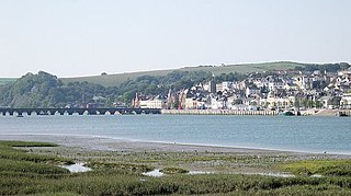
Featherston is a town in the South Wairarapa District, in the Wellington Region of New Zealand's North Island. It is at the eastern foothills of Remutaka Range close to the northern shore of Lake Wairarapa, 63 km (39 mi) north-east of central Wellington and 37 km (23 mi) south-west of Masterton.

Greytown, population 2,202, is a rural town in the heart of the Wairarapa region of New Zealand, in the lower North Island. It is 80 km north-east of Wellington and 25 kilometres southwest of Masterton, on State Highway 2. It was awarded the title of New Zealand's Most Beautiful Small Town 2017.
Te Whiti, formerly Te Whiti o Tu in the nineteenth century, is a rural community in the Wairarapa region of New Zealand's North Island. Its status has been under dispute and threatened in the twentieth century, and Land Information New Zealand acknowledges Te Whiti solely as a homestead. Its full former name means "the place of crossing" in the Māori language, reflecting its location near a natural crossing of the Ruamahanga River, which runs north and west of the locality and is met by the Tauweru River that flows across the south of Te Whiti. In relation to major Wairarapa centres, Te Whiti is south of Masterton and east of Carterton, while nearby communities include Te Whanga to the east and Gladstone and Longbush to the south. The Maungaraki Range is also nearby.
Tauweru, alternatively Taueru, and previously known as Wardell, or Wardelltown is a locality in the Wairarapa region of New Zealand's North Island. It is named after and located on the middle reaches of the Tauweru River, which drains into the Ruamahanga River near Gladstone and Te Whiti, and the name is a Māori-language word meaning "hanging in clusters".
Masterton was a New Zealand electorate from 1887 to 1946, focused on the town of Masterton and the surrounding area.

Renall Street railway station is an urban single-platform railway station on Renall Street in the Wairarapa town of Masterton in New Zealand’s North Island. Renall Street is one of three railway stations in Masterton, the others being Masterton and Solway.

Hood Aerodrome is an aerodrome, located in Masterton, New Zealand, it is located 1 NM South West of the town centre in the suburb of Solway. The aerodrome was named after George Hood, a pioneer Masterton aviator who died trying to make the first Trans-Tasman crossing in 1928. The aerodrome is used extensively for general aviation flights, and has also been used for commercial flights, Air New Zealand stopped serving the airport from 5 February 2014. Two new airlines have looked at re-instating a service to Auckland using larger aircraft but the runway will need to be lengthened to 1400m and widened to 30m first before it can start.

Makoura College is a state co-educational secondary school located in Masterton, New Zealand. The school opened in 1968 as the town's second state secondary school, alongside Wairarapa College. Serving Years 9 to 13, the school has a roll of 317 students as of March 2019.
Wairarapa College is a state coeducational secondary school located in Masterton, New Zealand. The college first opened in 1938, following the merger of Wairarapa High School with the Masterton Technical School. Serving Years 9 to 13, the college has 1098 students as of March 2019, including approximately 175 resident in the school's on-site boarding hostel, College House.
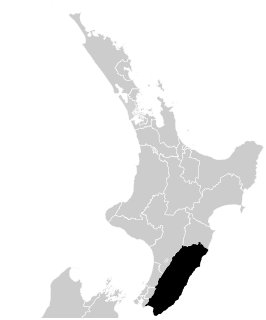
Wairarapa and Hawke's Bay is a former parliamentary electorate in the Wellington region of New Zealand, from 1853 to 1859, when it was extended into previously unincorporated territories, split in two and replaced by County of Hawke with its southern portion being the newly created Wairarapa electorate. It is the first general electorate to have been abolished in New Zealand.

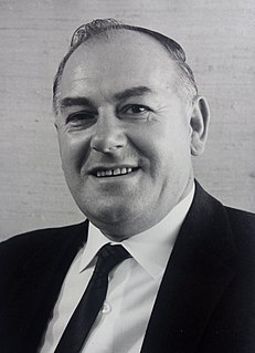
Haddon Vivian Donald, was a New Zealand soldier, businessman and politician of the National Party. He was the oldest living former New Zealand Member of Parliament, and at the time of his death, was the highest-ranking New Zealand army officer of World War II living. During the war, Donald served as an officer for the 22nd Battalion rising to the rank of lieutenant colonel. After his military service, Donald represented Wairarapa in the parliament from 1963 to 1969.

William Wilson McCardle JP was a member of the New Zealand Legislative Council. Born in Scotland, he came to New Zealand as a young man and lived in a variety of places. He was a nurseryman and advocated for land reform. He established the town of Pahiatua and it was in the Wairarapa district that his local government involvement was most influential. He stood in a number of general elections for Parliament, but was never successful. A committed liberal politician, he was appointed to the Legislative Council by the first Ward Ministry in 1907 and served for one term until 1914.
Wainuioru is small rural settlement in Wellington Region, New Zealand, just east of Masterton and north of Wainuioru River.

Kieran Michael McAnulty is a New Zealand politician and Member of Parliament in the House of Representatives for the Labour Party.