Related Research Articles

Stavanger Airport, commonly just known as Sola, is an international airport located in Rogaland county, Norway. The airport is located 6 NM southwest of the centre of the city of Stavanger inside the neighboring municipality of Sola and it serves the Stavanger, Sola, Sandnes area as well as serves as a regional hub for southwest Norway. It is Norway's third-busiest airport, with both fixed-wing aircraft and helicopter traffic for the offshore North Sea oil installations. In addition, the Royal Norwegian Air Force operates Westland Sea King search and rescue helicopters from Sola Air Station.
Christchurch Airport is the main airport that serves Christchurch, New Zealand. It is located 12 kilometres (7.5 mi) to the northwest of the city centre, in the suburb of Harewood. Christchurch (Harewood) Airport officially opened on 18 May 1940 and became New Zealand's first international airport on 16 December 1950. It is the second busiest airport in New Zealand, after Auckland and before Wellington by annual passengers, and the second busiest, after Auckland, by aircraft movements.
Tasman Empire Airways Limited (1940–1965), better known as TEAL, is the former name of Air New Zealand.

Whenuapai is a suburb and aerodrome located in northwestern Auckland, in the North Island of New Zealand. It is located on the shore of the Upper Waitematā Harbour, 15 kilometres to the northwest of Auckland's city centre. It is one of the landing points for the Southern Cross telecommunications Cables. The name is Māori for good land.
New Zealand National Airways Corporation, popularly known as NAC, established by the New Zealand National Airways Act, 1945, was the national domestic airline of New Zealand until 1978 when it amalgamated with New Zealand's international airline, Air New Zealand. The airline was headquartered in Wellington.

Hudson Valley Regional Airport, formerly known as Dutchess County Airport, is a county-owned public-use airport located on State Route 376 in the Town of Wappinger, Dutchess County, New York, United States, four miles (6 km) south of the central business district of Poughkeepsie. It is sometimes called Poughkeepsie Airport, which gives it the code POU. The airport provides corporate and general aviation transportation services.
RNZAF Base Ohakea is an operational base of the Royal New Zealand Air Force. Opened in 1939, it is located near Bulls, 25 km north-west of Palmerston North in the Manawatū. It is also a diversion landing point for civilian aircraft. The base's motto is Defensio per vires.

Whangārei Airport is an airport 4 nautical miles to the south east of Whangārei city, in the suburb of Onerahi, on the east coast of Northland in the North Island of New Zealand. The airport has a single terminal with two gates.
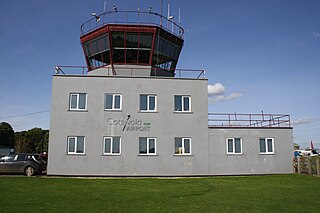
Cotswold Airport is a private general aviation airport, near the village of Kemble in Gloucestershire, England. Located 4.5 NM southwest of Cirencester, it was built as a Royal Air Force (RAF) station and was known as RAF Kemble. The Red Arrows aerobatics team was based there until 1983. Since 2000, it is used for the storage and recycling of retired airliners, as well as flying schools, clubs, and industry.

Jersey Airport is an international airport located in the parish of Saint Peter, 4 NM west northwest of Saint Helier in Jersey, in the Channel Islands.
South Pacific Airlines of New Zealand was a New Zealand airline, operating between 1960 and 1966. It is regarded as a forerunner to Ansett New Zealand.

New Plymouth Airport serves the city of New Plymouth, and the surrounding region of Taranaki. It is located on the west coast of New Zealand's North Island and is 11 km from the city centre, on State Highway 3 north to Auckland, and 4 km from the outer suburb/satellite town of Bell Block.

Invercargill Airport is a fully secured controlled international designated airport located 1.6 km west of the Central business district of Invercargill at the bottom of the South Island of New Zealand. It is the southernmost controlled airport in the Commonwealth. Formed on land reclaimed from the Waihopai/New River Estuary in 1938, the airport was prone to flooding, notably in 1984 when it was inoperable for two months. The Invercargill City Council considered moving the airport back to Dawson Farm, Myross Bush, the original site up to 1942. Instead, a large flood protection scheme was built, but during its construction heavy rain and an unusually high tidal surge flooded it again in 1987. There have been no problems since. The airport has a main secured terminal, a backup international secured terminal and 5 tarmac gates. Invercargill is the eleventh-busiest airport in New Zealand by passenger traffic.
Hastings Aerodrome is a small airport located in Hastings, Hawke's Bay, New Zealand. It is sometimes referred to as Bridge Pa Aerodrome. It is owned and operated by the Hawke's Bay & East Coast Aero Club Inc.

Imeson Field, also known as Jacksonville Imeson Airport, was the airport serving Jacksonville, Florida, from 1927 until its closing in 1968. It was known as Jacksonville Municipal Airport prior to World War II, Jacksonville Army Airfield when the United States Army Air Forces controlled the facility during World War II, and at its closing the airport was Jacksonville – Thomas Cole Imeson Municipal Airport.
Royal Air Force Pengam Moors, or more simply RAF Pengam Moors,, is a former Royal Air Force station and maintenance unit (MU), located on the Pengam Moors area of Tremorfa, situated 2 miles (3.2 km) south east of Cardiff city centre in Wales, from June 1938 to January 1946.
Kaikohe Aerodrome is an airfield south-east of Kaikohe in the Northland region of New Zealand. Built in 1942 as a US Marines bomber base, is the largest grass strip in the Southern hemisphere used now by general aviation. Other than powered aircraft, gliders use the airfield, and an area next to the runways is used by model airplane flyers. There are skydiving operations as well, with a landing spot near the old terminal.

Seagrove was an airport located by Clarks Beach on the south shoreline of Manukau Harbour, New Zealand, near the small town of Waiuku.

Mangere Aerodrome, named after a nearby suburb, was the original home of the Auckland Aero Club. It is now the site of Auckland Airport. Mangere Aerodrome's claim to fame was as the arrival point for New Zealand aviator, and aeroclub member, Jean Batten's solo flight from the United Kingdom in 1936. The RNZAF requisitioned the aerodrome from 1939 until 1944, renaming it RNZAF Station Mangere. In 1961, the Auckland Aero Club moved to Ardmore aerodrome and Mangere Aerodrome closed. The new Auckland Airport opened in 1965.
RNZAF Station Te Pirita was a World War II airfield, located south of the inland mid-Canterbury town of Hororata in New Zealand. Designed to accommodate United States Army Air Forces heavy bombers, at the time of its construction, it was to be the largest airfield in New Zealand, but it was never officially used.
References
| | This article about a New Zealand airport is a stub. You can help Wikipedia by expanding it. |