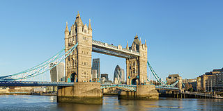
Tower Bridge is a Grade I listed combined bascule and suspension bridge in London, built between 1886 and 1894, designed by Horace Jones and engineered by John Wolfe Barry with the help of Henry Marc Brunel. It crosses the River Thames close to the Tower of London and is one of five London bridges owned and maintained by the City Bridge Foundation, a charitable trust founded in 1282. The bridge was constructed to give better access to the East End of London, which had expanded its commercial potential in the 19th century. The bridge was opened by Edward, Prince of Wales and Alexandra, Princess of Wales in 1894.
Taranaki is a region in the west of New Zealand's North Island. It is named after its main geographical feature, the stratovolcano Mount Taranaki, also known as Mount Egmont.
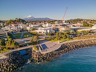
New Plymouth is the major city of the Taranaki region on the west coast of the North Island of New Zealand. It is named after the English city of Plymouth, in Devon, from where the first English settlers to New Plymouth migrated. The New Plymouth District, which includes New Plymouth City and several smaller towns, is the 10th largest district in New Zealand, and has a population of 88,900 – about two-thirds of the total population of the Taranaki Region and 1.7% of New Zealand's population. This includes New Plymouth City (59,600), Waitara (7,550), Inglewood (3,870), Ōakura (1,730), Ōkato (561) and Urenui (429).
The First Taranaki War was an armed conflict over land ownership and sovereignty that took place between Māori and the New Zealand government in the Taranaki district of New Zealand's North Island from March 1860 to March 1861.

The Auckland Harbour Bridge is an eight-lane motorway bridge over the Waitematā Harbour in Auckland, New Zealand. It joins St Marys Bay on the Auckland city side with Northcote on the North Shore side. It is part of State Highway 1 and the Auckland Northern Motorway. The bridge is operated by the NZ Transport Agency (NZTA). It is the second-longest road bridge in New Zealand, and the longest in the North Island.

Waitara is a town in the northern part of the Taranaki region of the North Island of New Zealand. Waitara is located just off State Highway 3, 15 kilometres (9.3 mi) northeast of New Plymouth.

Grafton Bridge is a road bridge spanning Grafton Gully in Auckland, New Zealand. Built of reinforced concrete in 1910, it connects the Auckland CBD and Karangahape Road with Grafton. It spans about 97.6 metres, rises 25.6 metres above the abutments to a height of around 43 metres over the gully. When the bridge was constructed, it contained the largest reinforced concrete arch in the world.
The Taranaki Flyer was the name given to a passenger train that was operated by the New Zealand Railways Department between Whanganui and New Plymouth from 1926 to 1965.
The Stratford–Okahukura Line (SOL) is a secondary railway line in the North Island of New Zealand, between the Marton - New Plymouth Line (MNPL) and the North Island Main Trunk (NIMT) Railway, with 15 intermediate stations. It is 144 km (89 mi) long through difficult country, with 24 tunnels, 91 bridges and a number of sections of 1 in 50 grade. Near Okahukura there is an unusual combined road-rail bridge over the Ongarue River, with the one-lane road carriageway below the single rail track. The line is not currently in service for rail traffic and is under a 30-year lease for a tourist venture. In July 2019 KiwiRail's CEO stated that reopening the line was a priority. Minister of Transport Michael Wood announced the government's 10-year plan for rail investment on 6 May 2021, which specifically stated that plans could include re-opening the Stratford to Okahukura line.

The Historic Kopu Bridge is a single-lane swing bridge that spans the Waihou River, near its emergence into the Firth of Thames in the Thames-Coromandel District of New Zealand's North Island. The bridge was completed in 1928 and was part of State Highway 25. The swinging span in the middle of the bridge is 43 metres long and with an overall length of 463 metres, the bridge was the longest and oldest single lane bridge within the state highway network. It is also New Zealand's only remaining operational swing bridge.
The source of the Waitara River lies in the very steep hill country to the east of Mount Taranaki/Egmont, near Tahora. After proceeding in a southwesterly direction toward Central Taranaki, the river abruptly turns to flow in a northwesterly direction to the Tasman Sea: meeting it at the coastal town of Waitara.
The Rimutaka Incline Railway Heritage Trust is a non-profit, charitable trust in New Zealand that was established in 2003 with the objective of reinstating an operating heritage railway over the Remutaka Ranges using the original route of the Wairarapa Line between Maymorn and Featherston, including the world-famous Rimutaka Incline.
Urenui is a settlement in northern Taranaki, in the North Island of New Zealand. It is located on State Highway 3 close to the shore of the North Taranaki Bight, 13 kilometres east of Waitara and 6 km south-west of Mimi. The Urenui River flows past the settlement into the North Taranaki Bight.
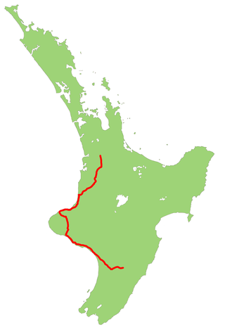
State Highway 3 (SH 3) is one of New Zealand's eight national state highways. It serves the west coast of the country's North Island and forms a link between State Highway 1 and State Highway 2. Distances are measured from north to south.

Tikorangi is a settlement in Taranaki, New Zealand. Waitara lies about 6 kilometres to the north-west. The Waitara River flows to the west of the settlement, with the Bertrand Road suspension bridge providing access to the other side. The Mangaemiemi or Otaraua Marae and Te Ahi Kaa Roa meeting house are a local meeting place for Otaraua, a hapū of Te Āti Awa.

Arapuni Power Station is a hydroelectric power station on the Waikato River, in the North Island of New Zealand. It is owned and operated by Mercury Energy, and is the seventh and penultimate hydroelectric power station on the Waikato River. It is also the oldest currently generating, the first government-built, and the largest capacity single hydroelectric power station on the Waikato River. The two power houses that make up the Maraetai Power Station have a larger combined capacity however.
The Waitara Branch is a 7.245 km long branch line railway in the Taranaki region of New Zealand's North Island. It was built as part of the region's first railway, linking New Plymouth with the closest suitable port, then the river port of Waitara. In 1884 the Breakwater port was opened in New Plymouth, but the line was saved when a (meat) freezing works was opened at Waitara in 1885.

The Waitara Railway Preservation Society is a society established in 1999 to operate a heritage railway over the former Waitara Industrial Line railway that operated between Lepperton and Waitara in the New Plymouth District of New Zealand's North Island. The line had been closed that year after 124 years of operation, after the closure of the local AFFCO freezing works in the town.
The Kapuni Branch, formerly known as the Opunake Branch, is a branch railway in North Island, New Zealand. It opened in 1926, and ran 36.4 km across the southern slopes of Mount Taranaki to link the rural town of Ōpunake with the Marton–New Plymouth Line 2 km north of the small rural settlement of Te Roti, equidistant between Eltham and Hāwera. With the decline of rural freight, part of the line was closed in 1976, but the 10.9 km section to Kapuni was retained and upgraded to service traffic to the Kapuni natural gas field.
Waiongona railway station was a rural railway station on the Marton - New Plymouth Line serving the small locality of Waiongona in New Zealand's Taranaki district. Located on Mountain Road, the station was relocated from its original site in 1893. The station closed to all traffic in 1958, though freight trains continue to pass through the station site.

