Demographics
Welbourn covers 6.87 km2 (2.65 sq mi) [1] and had an estimated population of 3,520 as of June 2023, [2] with a population density of 512 people per km2.
Historical population| Year | Pop. | ±% p.a. |
|---|
| 2006 | 2,796 | — |
|---|
| 2013 | 2,997 | +1.00% |
|---|
| 2018 | 3,261 | +1.70% |
|---|
| Source: [5] |
Before the 2023 census, the suburb had a smaller boundary, covering 6.49 km2 (2.51 sq mi). [1] Using that boundary, Welbourn had a population of 3,261 at the 2018 New Zealand census, an increase of 264 people (8.8%) since the 2013 census, and an increase of 465 people (16.6%) since the 2006 census. There were 1,215 households, comprising 1,701 males and 1,563 females, giving a sex ratio of 1.09 males per female. The median age was 40.4 years (compared with 37.4 years nationally), with 648 people (19.9%) aged under 15 years, 609 (18.7%) aged 15 to 29, 1,392 (42.7%) aged 30 to 64, and 612 (18.8%) aged 65 or older.
Ethnicities were 84.6% European/Pākehā, 14.5% Māori, 2.5% Pacific peoples, 7.9% Asian, and 1.6% other ethnicities. People may identify with more than one ethnicity.
The percentage of people born overseas was 18.9, compared with 27.1% nationally.
Although some people chose not to answer the census's question about religious affiliation, 49.7% had no religion, 37.7% were Christian, 0.5% had Māori religious beliefs, 1.5% were Hindu, 1.4% were Muslim, 0.6% were Buddhist and 1.5% had other religions.
Of those at least 15 years old, 573 (21.9%) people had a bachelor's or higher degree, and 450 (17.2%) people had no formal qualifications. The median income was $29,900, compared with $31,800 nationally. 483 people (18.5%) earned over $70,000 compared to 17.2% nationally. The employment status of those at least 15 was that 1,164 (44.5%) people were employed full-time, 456 (17.5%) were part-time, and 81 (3.1%) were unemployed. [5]
Education
The Western Institute of Technology at Taranaki has its main campus in Welbourn. [6]
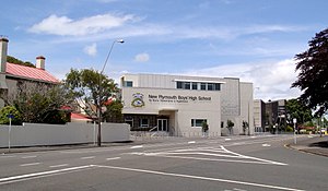
New Plymouth Boys' High School is a single-sex state secondary school (years 9–13) with a roll of 1,161 students. [7] The school was built as New Plymouth High School in 1882 and was initially only for boys. It became co-educational in 1885, although the girls were taught separately for the first two years. The girls separated from New Plymouth High School in 1914, forming New Plymouth Girls' High School in Strandon, leaving New Plymouth Boys' High School on the old site. [8]
Central School Te Kura Waenga o Ngāmotu is a coeducational contributing primary (years 1–6) schools with a roll of 262. [9] Central School opened in 1884 and is one of the oldest schools in the region. [10]
Welbourn School is a coeducational contributing primary (years 1-6) school with a roll of 297 students. [11] It was built on railway reserve land in 1932 [4] and celebrated its 75th jubilee in 2008. [12]
Rolls are as of February 2024. [13]

Henderson is a major suburb of West Auckland, in the North Island of New Zealand. It is 13 kilometres (8.1 mi) west of Auckland city centre, and two kilometres (1.2 mi) west of the Whau River, a southwestern arm of the Waitematā Harbour. The suburb is located within the Henderson-Massey Local Board of the Waitākere Ward, one of the thirteen administrative divisions of Auckland Council.
Ruakura is a semi-rural suburb of Hamilton City, in the Waikato region of New Zealand. The University of Waikato is nearby.

Ōpunake is a small town on the southwest coast of Taranaki in New Zealand's North Island. It is located 45 kilometres southwest of New Plymouth. Rahotu is 16 km to the northwest. Manaia is 29 km to the southeast. State Highway 45 passes through the town. The town has a population of 1,440.
Hāwera is the second-largest centre in the Taranaki region of New Zealand's North Island, with a population of 10,350. It is near the coast of the South Taranaki Bight. The origins of the town lie in a government military base that was established in 1866, and the town of Hāwera grew up around a blockhouse in the early 1870s.

Seatoun, an eastern suburb of Wellington, the capital city of New Zealand, lies on the east coast of the Miramar Peninsula, close to the entrance to Wellington Harbour, some seven kilometres southeast of the CBD. The suburb sits on an exposed promontory close to Barrett Reef, a dangerous area of rocky shallows upon which many ships have foundered, most notably the inter-island ferry TEV Wahine in 1968.

Spreydon is a suburb of Christchurch, New Zealand, 4 kilometres (2.5 mi) south-south-west of Cathedral Square. The most central street through Spreydon is Barrington Street. Spreydon is flanked by the suburbs Hoon Hay, Sydenham, and Lower Cashmere. State Highway 76 marks the northern boundary of the suburb, including the eastern end of the Christchurch Southern Motorway.

Somerfield is a suburb in the south of Christchurch, New Zealand. It is nominally bordered by the Ōpāwaho / Heathcote River to the south and west, Strickland and Colombo Streets to the east, and Milton Street to the north. The suburb includes Somerfield School, Somerfield Park and a small number of shops which service the local area, although it is predominantly residential. Somerfield is also known for its wide variety of trees, especially along the banks of the Ōpāwaho / Heathcote River.

Tikipunga is one of the biggest suburbs in Whangārei, New Zealand. It is in the north-east part of the city and has the landmark Whangārei Falls nearby.

Westown is a suburb of New Plymouth, in the western North Island of New Zealand. It is located to the southwest of the city centre and west of Frankleigh Park.

Moturoa is a coastal suburb of New Plymouth, in the western North Island of New Zealand. It is located to the west of the city centre, bordering Port Taranaki and the Sugar Loaf Islands. One of the islands, Moturoa, the largest, shares its name with the suburb.

Fitzroy is a coastal suburb of New Plymouth, in the western North Island of New Zealand. It is located to the north-east of the city centre.
Panguru is a community in the northern Hokianga harbour, in Northland, New Zealand. The Whakarapa Stream flows from the Panguru Range in the Warawara Forest to the west, through Panguru and into the Hokianga.
Otangarei is a suburb of Whangārei, in Northland Region, New Zealand.

Spotswood is a suburb of New Plymouth in the Taranaki Region of New Zealand. It is located to the west of the city centre.

Uruti is a locality in northern Taranaki, in the North Island of New Zealand. It is located on State Highway 3, north-east of Mimi and south-west of Ahititi. The Uruti Stream meets the Mimi River at this point. The river flows past the settlement into the North Taranaki Bight.
Hoon Hay is an outer suburb of Christchurch, New Zealand, located at the base of the Port Hills and about 5 kilometres (3.1 mi) southwest of Cathedral Square. The area was named by Captain Wickham Talbot Harvey, a captain of the British Royal 10th Hussars, who moved to the area in 1852 and named it after the farm in Hoon, Derbyshire where he grew up. Harvey only stayed in the area for four years, before a fire destroyed his property and prompted him to return to the United Kingdom. Further fires in the following years destroyed the woodland which was on the property, including several large Tōtara, causing it to be converted into farmland. Remnants of this forest remain visible in the area, including with tree stumps being discovered during flood mitigation work on the Ōpāwaho / Heathcote River.

Waitākere is a small, mostly rural settlement to the northwest of Auckland, New Zealand.
Riverdale is a suburb of Gisborne, in the Gisborne District of New Zealand's North Island.
Rānui is a suburb of West Auckland, New Zealand, which is under the local governance of Auckland Council. The area is densely populated but close to the western fringe of the Auckland urban area.
Randwick Park is a suburb of Auckland, New Zealand.