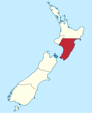
Wellington Province, governed by the Wellington Provincial Council, was one of the provinces of New Zealand from 1853 until the abolition of provincial government in 1876. It covered much of the southern half of the North Island until November 1858, when Hawke's Bay Province split off, taking about a third of its area.

The Taranaki Province was a province of New Zealand from 1853 until the abolition of provincial government in 1876. Initially known as New Plymouth Province, the province was renamed on 1 January 1859 as the Taranaki Province.

The River Gum Walk Trail is a shared use path for cyclists and pedestrians in the suburb of Rosanna, an inner northern suburb of Melbourne, Victoria, Australia.
New Plymouth District Council is the territorial authority for the New Plymouth District of New Zealand.
Vogeltown is a suburb of New Plymouth, in the western North Island of New Zealand. It is located to the southeast of the city centre and east of Frankleigh Park. The suburb was named after Sir Julius Vogel, Prime Minister of New Zealand in the 1870s.
Cardiff is a settlement in inland Taranaki, in the western North Island of New Zealand. It is located five kilometres southwest of Stratford close to Egmont National Park.
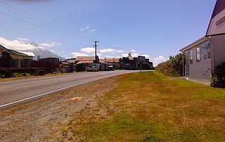
Waipuku is a settlement in inland Taranaki, in the western North Island of New Zealand. It is located between Stratford and Inglewood on State Highway 3.
Southern Cross group, a collection of independent, health-oriented businesses in New Zealand, operates on not-for-profit principles and is New Zealand's largest non-public health care organisation. The Group's businesses include health insurance, private hospitals and healthcare, travel insurance and pet insurance. The Group encompasses the Southern Cross Medical Care Society and the Southern Cross Health Trust and their respective subsidiaries.
South Albury is a suburb of the city of Albury, New South Wales, located 3 kilometres (2 mi) south of the Albury Central Business District. At the 2006 census, South Albury had a population of 1102.

Pukekura Park is a Garden of National Significance, covering 52 hectares in the heart of New Plymouth, Taranaki in New Zealand.
McKee field is an oil and gas producing field in Taranaki, New Zealand. It is located 20 km south east of New Plymouth. The field is now owned and operated by subsidiaries of Todd Energy.

Te Rewa Rewa Bridge is a pedestrian and cycleway bridge across the Waiwhakaiho River at New Plymouth in New Zealand. Its spectacular shape and setting make it a popular landmark.

The TSB Festival of Lights is an annual event held in Pukekura Park, New Plymouth. Running for free every year from mid-December to late January, it has a daytime and night time programme of events for people of all ages, with light installations illuminating the park. In 2021 the festival won the Best Local Government and NZ's Favourite Event Awards at the 2021 NZ Events Association Awards.

The Coastal Walkway is a 12.7-kilometre (7.9 mi) long walkway located along the coast of New Plymouth, New Zealand. The walkway stretches from near Port Taranaki, past the central city, through Hickford Park, past Bell Block Beach and to Tiromoana Crescent in Bell Block, north-east of New Plymouth. The walkway runs through a number of bridges, most notably, the Te Rewa Rewa Bridge.
The Waipu Lagoons is a series of small coastal lagoons near the city of New Plymouth in the Taranaki Region of New Zealand. They consist of three lakelets with a combined surface area of about 2 hectares, located 0.5 kilometres (0.31 mi) from the Tasman Sea, immediately to the east of Bell Block. The lagoons and adjoining wetlands encompass 7.9 hectares and are owned by the New Plymouth District Council as a local purpose conservation reserve.

Coleman was an electoral ward and administrative division of the city of Leicester, England, consisting of the Leicester suburbs of Crown Hills and North Evington. It was replaced by North Evington ward in 2015.

The Waitara Railway Preservation Society is a society established in 1999 to operate a heritage railway over the former Waitara Industrial Line railway that operated between Lepperton and Waitara in the New Plymouth District of New Zealand's North Island. The line had been closed that year after 124 years of operation, after the closure of the local AFFCO freezing works in the town.
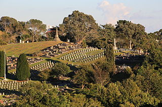
Te Henui Cemetery, also known as New Plymouth Cemetery, is the oldest public cemetery in New Plymouth, New Zealand. It was first used in 1861.

The Taranaki District Health Board was a district health board which provided healthcare to the Taranaki region of New Zealand. In July 2022, the Taranaki DHB was merged into the national health service Te Whatu Ora.
Inglewood railway station is a single-platform railway station on the Marton - New Plymouth Line serving the town of Inglewood in New Zealand's Taranaki district. Located on Moa Street, the station is the oldest remaining railway station in New Zealand still on its original site.