Waitara River

Last updated

Waitara River in Waitara Waitara 1.jpg
Waitara River in Waitara

The source of the Waitara River lies in the very steep hill country to the east of Mount Taranaki/Egmont, near Tahora. After proceeding in a southwesterly direction toward Central Taranaki, the river abruptly turns to flow in a northwesterly direction to the Tasman Sea: meeting it at the coastal town of Waitara. [1]

Tahora, Manawatu-Wanganui Place in Manawatu-Wanganui Region, New Zealand

Tahora is a small settlement located in the Manawatu-Wanganui Region in the North Island of New Zealand along the Stratford–Okahukura railway line and State Highway 43 between Stratford and Taumarunui. It was the location of an annual folk music festival for 30 years.

Taranaki Region of New Zealand in North Island

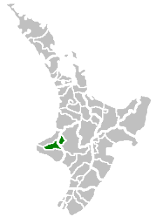
Taranaki is a region in the west of New Zealand's North Island. It is named after its main geographical feature, the stratovolcano of Mount Taranaki.

Tasman Sea A marginal sea of the South Pacific between Australia and New Zealand

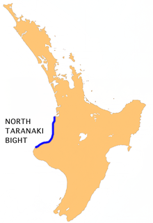
The Tasman Sea is a marginal sea of the South Pacific Ocean, situated between Australia and New Zealand. It measures about 2,000 km (1,200 mi) across and about 2,800 km (1,700 mi) from north to south. The sea was named after the Dutch explorer Abel Janszoon Tasman, who was the first recorded European to encounter New Zealand and Tasmania. British explorer Captain James Cook later extensively navigated the Tasman Sea in the 1770s as part of his first voyage of exploration.

Contents

The river once had a dock in Waitara, where export meat from the town's Thos. Borthwick & Sons freezing-works was loaded onto ships. However, this trade was subsequently conducted from New Plymouth's Port Taranaki until the works closed in 1995.

Waitara, New Zealand Place in Taranaki, New Zealand

Waitara is a town in the northern part of the Taranaki region of the North Island of New Zealand. Waitara is located just off State Highway 3, 15 kilometres (9.3 mi) northeast of New Plymouth. Its population was 6312 in the 2013 census, an increase of 24 from 2006.

New Plymouth City in Taranaki, New Zealand

New Plymouth is the major city of the Taranaki Region on the west coast of the North Island of New Zealand. It is named after the English city of Plymouth from where the first English settlers migrated. The New Plymouth District, which includes New Plymouth City and several smaller towns, is the 10th largest district in New Zealand, and has a population of 74,184 – about two-thirds of the total population of the Taranaki Region and 1.7% of New Zealand's population. This includes New Plymouth City (58,300), Waitara (6,483), Inglewood (3,380), Oakura (1,359), Okato (561) and Urenui (429).

Port Taranaki

Port Taranaki is a port complex located in New Plymouth, New Zealand. It is the only deep water port on the west coast of New Zealand, and is owned by the Taranaki Regional Council. The port handles a wide range of coastal and international cargoes, mostly relating to the farming, engineering and petrochemical industries. Shipping volumes decreased significantly over the period 2012 to 2015.

The Waitara is the first mud-bottomed river to the north of Cape Egmont. It is prone to flooding, and there are stop banks (levees) to the west of the river (upstream from the bridge) and on both sides downstream.

Cape Egmont human settlement in New Zealand

Cape Egmont, splitting Northern and Southern Taranaki Bights, is the westernmost point of Taranaki, on the west coast of New Zealand's North Island. It is located close to the volcanic cone of Mount Taranaki or Mount Egmont. It was named Kaap Pieter Boreel by Dutch explorer Abel Tasman in 1642, but renamed Cape Egmont by British explorer James Cook in 1769.. Ironically, the cape retained a Dutch name, as Cook named the mountain and cape after the Earl of Egmont, who claimed descent of the Dutch House of Egmond.

The historic Bertrand Road suspension bridge, (one of only a few such road bridges in New Zealand) is several kilometres from State Highway 3 (just up from the town).

Bertrand Road suspension bridge

The Bertrand Road suspension bridge crosses the Waitara River, linking Huirangi, near Lepperton and Tikorangi in north Taranaki, New Zealand. The original bridge was built in 1897, and rebuilt in 1927.

New Zealand State Highway 3 road in New Zealand

State Highway 3 (SH 3) is one of New Zealand's eight national state highways. It serves the west coast of the country's North Island and forms a link between State Highway 1 and State Highway 2. Distances are measured from north to south.

New Zealand Wars

In December 1860 during the First Taranaki War campaign of the New Zealand Wars, British forces under Major-General Pratt carried out sapping operations against a major Māori defensive line called Te Arei ("The barrier") on the west side of the Waitara River, which was barring the way to the historic hill pā of Pukewairangi. During this operation, Colour Serjeant John Lucas was awarded the Victoria Cross on 18 March 1861.

The First Taranaki War was an armed conflict over land ownership and sovereignty that took place between Māori and the New Zealand Government in the Taranaki district of New Zealand's North Island from March 1860 to March 1861.

New Zealand Wars 1845–1872 armed conflicts in New Zealand

The New Zealand Wars were a series of armed conflicts that took place in New Zealand from 1845 to 1872 between the Colonial government and allied Māori on one side and Māori and Māori-allied settlers on the other. They were previously commonly referred to as the Land Wars or the Māori Wars while Māori language names for the conflicts included Ngā pakanga o Aotearoa and Te riri Pākehā. Historian James Belich popularised the name "New Zealand Wars" in the 1980s, although the term was first used by historian James Cowan in the 1920s.

John Lucas (VC) Irish recipient of the Victoria Cross

John Lucas VC was a British Army soldier and a recipient of the Victoria Cross, the highest award for gallantry in the face of the enemy that can be awarded to British and Commonwealth forces.

Water quality

Historically, water quality of the Waitara River was poor due to uncontrolled discharges of untreated Waitara town sewage and to industrial wastes from the meatworks. The river was observed to run red with discharges from the meatworks. The water quality improved significantly following the 1978 construction of an ocean outfall for sewage and following shutdown of the meatworks. Until 1999, sewage from Inglewood was discharged into the river. [2]

In terms of e.coli levels, the Waitara River is listed as the second worst of 77 sites listed in the NIWA National River Water Quality Network, ranked as suitable for contact recreation, e.g. swimming. [3]

Related Research Articles

Stratford, New Zealand Place in Taranaki, New Zealand

Stratford is the only town in Stratford District, and the seat of the Taranaki Region, in New Zealand's North Island. It lies beneath the eastern slopes of Mount Taranaki/Egmont, approximately halfway between New Plymouth and Hawera, near the geographic centre of the Taranaki Region. The town has a population of 5,740, making it the 47th largest urban area in New Zealand, and the fourth largest in Taranaki.

Wiremu Kīngi Te Rangitāke, Māori Chief of the Te Āti Awa Tribe, was leader of the Māori forces in the First Taranaki War.

Mount Taranaki mountain on North Island, New Zealand

Mount Taranaki, or Mount Egmont, is a dormant stratovolcano in the Taranaki region on the west coast of New Zealand's North Island. Although the mountain is more commonly referred to as Taranaki, it has two official names under the alternative names policy of the New Zealand Geographic Board. The 2,518 metres (8,261 ft) mountain has a secondary cone, Fanthams Peak, 1,966 metres (6,450 ft), on its south side. Because of its resemblance to Mount Fuji, Taranaki provided the backdrop for the movie The Last Samurai.

Eltham, New Zealand Place in Taranaki, New Zealand

Eltham is a small inland town in South Taranaki, New Zealand, located 50 kilometres (31 mi) south of the city of New Plymouth and southeast of the volcanic cone of Mount Taranaki/Egmont. Stratford is 11 kilometres (6.8 mi) north, Kaponga 13 km west, and Hawera is 19 km (12 mi) south. State Highway 3 runs through the town.

North Taranaki Bight bay

The North Taranaki Bight is a large bay that extends north and east from the north coast of Taranaki in New Zealand's North Island. The name is echoed by the South Taranaki Bight to the south of Cape Egmont.

Mokau human settlement in New Zealand

Mokau is a small town on the west coast of New Zealand's North Island, located at the mouth of the Mokau River on the North Taranaki Bight. Mokau is in the Waitomo District and Waikato Region local government areas, just north of the boundary with the New Plymouth District and the Taranaki Region. Prior to 1989, the town was classed as being in Taranaki, and there is still a feeling that the community of interest is most associated with New Plymouth, 90 km to the southwest. State Highway 3 passes through the town on its route from Te Kuiti to Waitara and, eventually, New Plymouth.

Urenui Place in Taranaki, New Zealand

Urenui is a settlement in northern Taranaki, in the North Island of New Zealand. It is located on State Highway 3 close to the shore of the North Taranaki Bight, 13 kilometres east of Waitara and 6 km south-west of Mimi. The Urenui River flows past the settlement into the North Taranaki Bight.

Motunui Place in Taranaki, New Zealand

Motunui is a settlement in northern Taranaki, in the North Island of New Zealand. It is located on State Highway 3 close to the shore of the North Taranaki Bight, six kilometres east of Waitara.

Tongaporutu Place in Taranaki, New Zealand

Tongaporutu is a settlement in northern Taranaki, in the North Island of New Zealand. It is located on State Highway 3 at the mouth of the Tongaporutu River, 15 kilometres south of Mokau.Tongaporutu is well known in New Zealand for its 'Three Sisters' rock formations and its Maori petroglyphs carved into cave rock walls. However,both the Maori rock carvings and the 'Three Sisters formations are constantly being eroded by the Tasman sea.

The rivers of New Zealand are used for a variety of purposes and face a number of environmental issues. Many of the rivers in the South Island are braided rivers.

Waitetuna River river in New Zealand

The Waitetuna River is a river of the Waikato Region of New Zealand's North Island. It flows generally northwest from its sources southwest of Whatawhata to reach the southeastern coast of the Raglan Harbour.

Waiwhakaiho River river in New Zealand

The Waiwhakaiho River is a river of the Taranaki Region of New Zealand's North Island. One of many rivers and streams radiating from the slopes of Taranaki/Mount Egmont, it flows initially northeast before veering northwest to reach the Tasman Sea close to the New Plymouth suburb of Fitzroy. Near the sea, it is crossed by the coastal walkway, connecting New Plymouth with Bell Block via the Te Rewa Rewa Bridge.

The southernmost of New Zealand's Manganui Rivers flows through the Taranaki Region of New Zealand's North Island. It initially flows east from its sources on the slopes of Taranaki/Mount Egmont, turning north close to Midhirst and joining with the waters of the Waitara River ten kilometres from the North Taranaki Bight coast.

The Waitara Railway Preservation Society is a society established in 1999 to operate a heritage railway over the former Waitara Industrial Branch Railway that operated between Lepperton and Waitara in the New Plymouth District of New Zealand's North Island. The line had been closed that year after 124 years of operation, after the closure of the local AFFCO freezing works in the town.

Ahukawakawa Swamp

The Ahukawakawa Swamp is an area of sphagnum bog in Egmont National Park in the Taranaki Region of New Zealand. It was formed approximately 3,500 years ago and is of particular interest to botanists. Over 260 species of higher plant have been recorded there. The area of the swamp is approximately 1 km2.

References

  1. Wright-Taylor, Thomas Ludovic. "'WAITARA RIVER' from An Encyclopaedia of New Zealand, edited by A.H. McLintock, originally published in 1966. Te Ara - The Encyclopaedia of New Zealand, updated 18-Sep-2007" . Retrieved 31 December 2007.
  2. "Extensive record of actions to reduce pollution at Waitara". Taranaki Regional Council. 21 June 2010.
  3. "League table of the suitability of New Zealand rivers for contact recreation". NIWA . Retrieved 8 June 2016.

Coordinates: 38°59′S174°14′E / 38.983°S 174.233°E / -38.983; 174.233