
The North Island, also officially named Te Ika-a-Māui, is one of the two main islands of New Zealand, separated from the larger but much less populous South Island by Cook Strait. The island's area is 113,729 square kilometres (43,911 sq mi), making it the world's 14th-largest island. It has a population of 3,896,200, accounting for approximately 77% of the total residents of New Zealand.

The Northland Region is the northernmost of New Zealand's 16 local government regions. New Zealanders sometimes call it the Winterless North because of its mild climate. The main population centre is the city of Whangārei, and the largest town is Kerikeri.

The Far North District is the northernmost territorial authority district of New Zealand, consisting of the northern part of the Northland Peninsula in the North Island. It stretches from North Cape and Cape Reinga / Te Rerenga Wairua in the north, down to the Bay of Islands, the Hokianga and the town of Kaikohe.
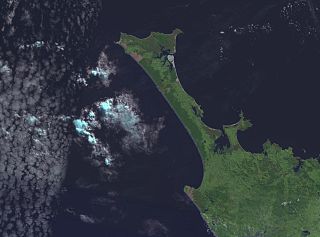
The Aupouri Peninsula is a tombolo at the northern tip of the North Island of New Zealand. It projects between the Tasman Sea to the west and the Pacific Ocean to the east. It constitutes the northern part of the Far North District, incorporating North Cape, Houhora and the northern half of Awanui.

The Karikari Peninsula on the east coast of the far north of Northland is between Rangaunu Harbour to the west, and Doubtless Bay to the southeast. It is a right-angled land mass of two relatively distinct parts. The rocky northern part, which has an east–west orientation and is approximately 17 km long, was originally an island but is now connected to the mainland by a low sandy tombolo approximately 11 km long, which has a north–south orientation. The spiritually significant Puwheke sits high above the north-facing beaches.
Bulrush Lake is a small lake on the Aupouri Peninsula in the Northland Region of New Zealand. It has a wetland area at its southwest end, but no flow outlet. On the north side of the lake there is an inflow drain. The catchment is predominately pine forest and pasture, with a small amount scrub to the west.
Half Mile Lagoon is a lake in the Northland Region of New Zealand. It is located 5 km to the northwest of Ngataki, on the Aupouri Peninsula.
Lake Ngakapua is a dune lake in the Northland Region of New Zealand. It is located to the northwest of Awanui, near Waipapakauri on the Aupouri Peninsula.
Lake Rotokawau is a dune lake on the Aupouri Peninsula the Far North, New Zealand. The name is also used for lakes in the Kaipara District, Chatham Islands, in Bay of Plenty and near Lake Waikare in Waikato.

Lake Rotoroa is a dune lake in the Northland Region of New Zealand. It is located to the west of Awanui.
Lake Waiparera is a dune lake in the Northland Region of New Zealand.It is located immediately North-West of Waiharara on the Aupouri Peninsula. The lake is the largest of the Aupouri Lakes. The catchment is predominately pasture, with the remainder scrub or wetland. The lake has several inflows (drains), with no obvious outflows. The lake is easily accessed from SH1.
Lake Waiporohita is a dune lake in the Northland Region of New Zealand. It is located near Tokerau Beach on the Karikari Peninsula.

New Zealand's Northland Region is built upon a basement consisting mainly of greywacke rocks, which are exposed on the eastern side of the peninsula. In-place Eocene coal measures crop out at Kamo, near Whangarei, and Oligocene limestone crops out at Hikurangi, near Whangarei.
Rangaunu Harbour is a shallow harbour in the far north of New Zealand. It is situated on the east coast at the base of the Aupouri Peninsula. The name in Māori means "To pull out a shoal of fish". With an area of 115 square kilometres (44 sq mi) it is the fifth-largest harbour in New Zealand.
Muriwhenua are a group of northern Māori iwi, based in Te Hiku o te Ika, the northernmost part of New Zealand's North Island. It consists of five iwi, Ngāti Kurī, Ngāi Takoto, Te Pātū, Ngāti Kahu, Te Aupōuri and Te Rarawa, with a combined population of about 34,000 people. The spiritually significant Hokianga Harbour, located just to the south of the Maungataniwha Range, is of special significance to the Muriwhenua people.
Clitarchus tepaki is a stick insect that belongs to the common New Zealand genus Clitarchus. It is endemic to the North Cape area of New Zealand, in particular Te Paki and the Karikari Peninsula.
Lake Rotokawau is the name of numerous lakes in New Zealand:
Lake Heather is a dune lake in the Far North District of New Zealand. It is located west of the town of Awanui, and between the larger Lake Ngatu and Lake Rotoroa.
Lake Rotopokaka is a dune lake in the Far North District of New Zealand. It is adjacent to Tokerau Beach on the east coast of the Karikari Peninsula. The lake is also known as 'Coca Cola lake' as the peat and tannins in the water give the lake a distinct 'cola' colour.

Lake Rotokawau is a small volcanic lake 4.1 km (2.5 mi) east of Lake Rotorua in the Bay of Plenty region of New Zealand's North Island. The name is also used for lakes in the Kaipara District, Chatham Islands, on Aupouri Peninsula and near Lake Waikare in Waikato. Access is via Lake Rotokawau Road, from SH30 at Tikitere. The lake is owned and managed by Ngāti Rangiteaorere.
