Related Research Articles

Elliott Bay is a part of the Central Basin region of Puget Sound. It is in the U.S. state of Washington, extending southeastward between West Point in the north and Alki Point in the south. Seattle was founded on this body of water in the 1850s and has since grown to encompass it completely. The waterway it provides to the Pacific Ocean has served as a key element of the city's economy, enabling the Port of Seattle to become one of the busiest ports in the United States.

Alki Point is a point jutting into Puget Sound, the westernmost landform in the West Seattle district of Seattle, Washington. Alki is the peninsular neighborhood on Alki Point. Alki was the original settlement in what was to become the city of Seattle. It was part of the city of West Seattle from 1902 until that city's annexation by Seattle in 1907.
Fauntleroy Creek is a stream in the Fauntleroy neighborhood of West Seattle, Washington, United States. It flows for about a mile from its headwaters in the 32-acre (129,000 m²) ravine of Fauntleroy Park to its outlet just south of the state ferry terminal on Puget Sound's Fauntleroy Cove, dropping 300 feet (100 m) vertically along the way. It currently supports cutthroat trout and coho salmon.

Green Lake is a neighborhood in north central Seattle, Washington. Its centerpiece is the lake and park after which it is named.

West Seattle is a conglomeration of neighborhoods in Seattle, Washington, United States. It comprises two of the thirteen districts, Delridge and Southwest, and encompasses all of Seattle west of the Duwamish River. It was incorporated as an independent town in 1902 before being annexed by Seattle five years later. Among the area's attractions are its saltwater beach parks along Elliott Bay and Puget Sound, including Alki Beach Park and Lincoln Park. The area is also known for its views of the Olympic Mountains to the west and the Cascade Range to the east. One-third of Seattle's green space and urban forest is located in West Seattle, much of it in the West Duwamish Greenbelt.

Washington Park is a public park in Seattle, Washington, United States, most of which is taken up by the Washington Park Arboretum, a joint project of the University of Washington, the Seattle Parks and Recreation, and the nonprofit Arboretum Foundation. Washington Park also includes a playfield and the Seattle Japanese Garden in its southwest corner. To the north is Union Bay; to the west are Montlake and Madison Valley; to the south is the Washington Park neighborhood; and to the east is the Broadmoor Golf Club.

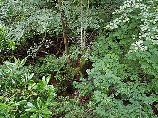
Schmitz Park, also known as Schmitz Preserve Park, is a 53.1-acre (21.5 ha) park around 15 blocks east of Alki Point in West Seattle, Washington. It features Schmitz Park Creek and one of the last stands of old-growth forest in the city.
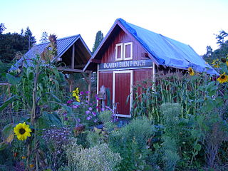
A P-Patch is a parcel of property used for gardening; the term is specific to Seattle, Washington. The "P" originally stood for "Picardo", after the family who owned Picardo Farm in Seattle's Wedgwood neighborhood, part of which became the original P-Patch.

Me-Kwa-Mooks Park is a 20.2-acre (82,000 m2) public park located in the West Seattle neighborhood of Seattle, Washington, USA. Me-Kwa-Mooks, meaning "shaped like a bear's head" and pronounced sbuh-KWAH-buks in Nisqually, was what the Duwamish tribe called the West Seattle peninsula when the first European-American settlers landed at Alki in 1851.

Fort Ward Park is park located along Rich Passage on the southern end of Bainbridge Island in Washington. Fort Ward Park is part of the Bainbridge Island Metro Park and Recreation District, on land which the former military base, Fort Ward, was located. It was a state park from 1960 to 2011 but is now locally managed.

Starfire Sports is a multi-purpose stadium and sporting facility in Tukwila, Washington, United States. It is located on the banks of the Green River, just south of Seattle. The stadium is operated by the nonprofit corporation Starfire Sports and is home to several soccer and rugby teams. At the time of its opening, CEO Chris Slatt claimed it was "the largest synthetic-turf soccer complex in the U.S."

Seaview is a neighborhood in West Seattle, Washington. Seaview is bordered by Puget Sound to the west, the Alki and Genesee neighborhoods to the north, Fairmount Park to the east, and Gatewood to the south.

Matia Island is an island in the San Juan Islands of the U.S. state of Washington. The island's entire 145 acres (59 ha) comes under the protection of the U.S. Fish and Wildlife Service and is cooperatively managed by the Washington State Parks and Recreation Commission as Matia Island Marine State Park. Matia Island is a National Wildlife Refuge, part of the San Juan Islands National Wildlife Refuge. A 2-acre (0.81 ha) camping area around Rolfe Cove is managed as a State Marine Park by the Washington State Parks and Recreation Commission under an agreement dating back to 1959. Pets, wood collecting, and campfires are not allowed on the island. Except for the Wilderness Loop Trail and the campground, all areas above the high tide line are closed to the public.

The steamboat Dix operated from 1904 to 1906 as part of the Puget Sound Mosquito Fleet. She was sunk in a collision which remains one of the most serious transportation accidents in the state of Washington to this day.
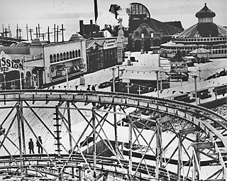
Luna Park was an amusement park in Seattle, Washington that operated from 1907 until 1913. Designed by famed carousel carver Charles I. D. Looff, who carved and installed Coney Island's very first carousel, Luna Park took its name from Coney Island's Luna Park. On July 4, 1908, Luna Park became the site of Seattle's first manned flight.

Boeing Plant 2 was a factory building which was built in 1936 by The Boeing Company in King County, Washington in the United States. By the time production ceased in the building, the plant had built half of the Boeing B-17 Flying Fortresses, the Boeing 307 Stratoliners, the Boeing 377s, some of the Boeing B-29 Superfortresses, Boeing B-50 Superfortresses, B-47 Stratojets, B-52 Stratofortresses, and the initial Boeing 737s. It was located between the Duwamish River and Boeing Field, to the east of the 16th Avenue South bridge, facing East Marginal Way South.

Brightwater is a regional sewage treatment plant in south Snohomish County, Washington, United States. It serves parts of the Seattle metropolitan area and was opened in 2011. The plant construction and associated tunneling were a five-year megaproject costing $1.8 billion.
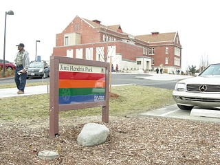
Jimi Hendrix Park is a 2.3-acre (0.93 ha) park in Seattle, Washington named in honor of musician Jimi Hendrix, who was from Seattle.

The Weyerhaeuser King County Aquatic Center is an aquatic facility in Federal Way, Washington constructed for the 1990 Goodwill Games.

The Statue of Liberty, or Lady Liberty, is a replica of the Statue of Liberty installed at Seattle's Alki Beach Park, in the U.S. state of Washington. It was installed in 1952 by the Boy Scouts of America and underwent a significant restoration in 2007 after repeated vandalism had damaged the sculpture.
References
Coordinates: 47°35′20″N122°22′48″W / 47.589°N 122.380°W
| | This King County, Washington state location article is a stub. You can help Wikipedia by expanding it. |