St Abbs

Last updated

St Abbs harbour as seen from the coastal path. St abbs borders scotland.jpg
St Abbs harbour as seen from the coastal path.

St Abbs is a small fishing village on the southeastern coast of Scotland, within the Coldingham parish of Scottish Borders.

Contents

The village was originally known as Coldingham Shore, the name St Abbs being adopted in the 1890s. The new name was derived from St Abb's Head, a rocky promontory located to the north of the village, itself named after the 7th-century saint Æbbe of Coldingham.

History

St Abbs Lifeboat the Thomas Tunnock is based in St Abbs St Abbs Lifeboat leaves St Abbs Harbour.jpg
St Abbs Lifeboat the Thomas Tunnock is based in St Abbs

St Abbs was originally called Coldingham Shore. Prior to any buildings the fishermen who worked their boats from the beach resided at Fisher's Brae in Coldingham. These fishermen had to carry their fishing gear one and a half miles down a path to where their fishing vessels were tied up. The path is now known as the Creel Path; creel is the local name for a lobster pot.

The first building in St Abbs was constructed in about the middle of the 18th century followed later by a row of five cottages. This first row of houses was constructed in a traditional Scottish style with a central fire and a wide chimney. The walls were constructed of "clat and clay," a framework of wood interlaced with straw and daubed with moist clay.

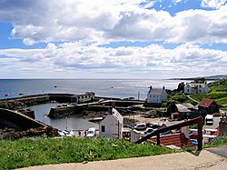
By 1832 it is recorded that the inhabitants of the Shore comprised 16 families who, with 20 others residing in Coldingham, made their living by fishing. In addition to these residents, 30 people proceeded annually to the north for the herring fishing, which provided employment for 14 boats from the village.

The village was renamed at the end of the 19th century by the then-laird, Andrew Usher, who played a major role in improving the fishing village and harbour. [1] Usher purchased the Northfield estate on the edge of the village, enlarging and finishing the building of a countryside manor by the coastal shore in 1892. [1] He considered the local public hall inadequate and subsequently funded a new village hall and school, which was constructed in 1887 and is now occupied by the St Abbs visitor centre. [1] Usher also gave funds for the building of the local church in 1892 and the extension of the outer harbour wall in 1890. [1]

In November 1907 the Member of Parliament (MP) for Berwickshire, Harold Tennant, announced that the Royal National Lifeboat Society had agreed to supply St Abbs with a lifeboat, and that the Board of Trade had also agreed to place life-saving apparatus at St Abbs as soon as possible. [2]

The RMS Mauretania during a speed trial off St Abbs, Scotland, 18 September 1907. The lighthouse and its buildings are still there and appear essentially the same. Mauretaniastabbs.jpg
The RMS Mauretania during a speed trial off St Abbs, Scotland, 18 September 1907. The lighthouse and its buildings are still there and appear essentially the same.

On 5 September 1914, HMS Pathfinder was sunk off St Abbs Head by the German U-21 , the first Royal Navy ship to be sunk by a U-boat.

St Abbs was the main subject of the book, Ebb Tide: Adrift on the Waves of Memory With the Fisher Folk of Berwickshire, by Will Wilson.

Village today

St Abbs is a popular site for scuba divers. The sea around the village is unusually clear, in contrast to the more silt-laden coastal waters further to the north or south. These clear waters and the spectacular underwater scenery resulted in Britain's first Voluntary Marine Reserve being established at St Abbs. The Marine Reserve was established on 18 August 1984 by David Bellamy.

Shore diving to a depth of about 15 metres is possible from the rocks on the outside of the harbour wall. It is common for trainees to do initial sea dives here.

The double archway at "Cathedral Rock" is just 50 metres from the shore. [3] [4] Several small, nearby rocky islands, such as "Big Green Carr", "Broad Craig" and "Little Carr" are near to the harbour and can be easily circumnavigated underwater. [5]

St Abbs Visitor Centre St Abbs Visitor Centre.JPG
St Abbs Visitor Centre

A new visitor centre was opened in St Abbs in March 2011. [6] The centre is located in the former village hall, which was built in 1897 with funds made available by the whisky tycoon Andrew Usher. [6]

St Abbs has its own privately funded and independent Lifeboat Station. [7] The lifeboat station was originally established in 1911 following the sinking of the S.S. Alfred Erlandsen. [8] The station was previously operated by the RNLI but following its closure in 2015, a local fundraising effort saw the station saved through public donations and generous funding from the Tunnock's bakery company. The station was reopened and the new boat launched on 17 September 2016. [7]

The village also features in the 2019 superhero film Avengers: Endgame as the location of New Asgard, a town settled by the surviving Asgardians and led by Thor. Following the film's release, the village saw a surge in tourism and popularity. The village sign has also been modified to say the village is twinned with New Asgard. [9] [10]

In 2019, St Abbs featured as the "Isle of Eroda" in the music video of Harry Styles' single "Adore You". [11]

St Abbs pan.jpg
center

People from St Abbs

Twinned towns

Signs have been erected throughout the village declaring that it has been twinned with "New Asgard", as it was the location of filming in Avengers: Endgame . [10] It also has been twinned with "Eroda", a fictitious island created by Harry Styles for his video Adore you (Harry Styles song). [12]

See also

Related Research Articles

<span class="mw-page-title-main">Sheringham</span> Seaside town in Norfolk, England

Sheringham is an English seaside town within the county of Norfolk, United Kingdom. The motto of the town, granted in 1953 to the Sheringham Urban District Council, is Mare Ditat Pinusque Decorat, Latin for "The sea enriches and the pine adorns".

<span class="mw-page-title-main">Gairloch</span> Human settlement in Scotland

Gairloch is a village, civil parish and community on the shores of Loch Gairloch in Wester Ross, in the North-West Highlands of Scotland. A tourist destination in the summer months, Gairloch has a golf course, a museum, several hotels, a variety of shops, takeaway restaurants, a community centre, a leisure centre with sports facilities, a local radio station, beaches and nearby mountains. Gairloch is one of the principal villages on the North Coast 500 route.

<span class="mw-page-title-main">Eyemouth</span> Coastal town in Berwickshire Scotland

Eyemouth is a small town and civil parish in Berwickshire, in the Scottish Borders area of Scotland. It is two miles east of the main north–south A1 road and eight miles north of Berwick-upon-Tweed.

<span class="mw-page-title-main">Isle of Whithorn</span> Human settlement in Scotland

Isle of Whithorn is one of the most southerly villages and seaports in Scotland, lying on the coast north east of Burrow Head, about three miles from Whithorn and about thirteen miles south of Wigtown in Dumfries and Galloway. Whithorn,, is a former royal burgh in Wigtownshire, Dumfries and Galloway, with which Isle of Whithorn is frequently incorrectly amalgamated or confused. It is referred to locally as 'The Isle' - never 'the Isle of Whithorn'.

<span class="mw-page-title-main">Dunmore East</span> Fishing village in County Waterford, Ireland

Dunmore East is a popular tourist and fishing village in County Waterford, Ireland. Situated on the west side of Waterford Harbour on Ireland's southeastern coast, it lies within the barony of Gaultier ; a reference to the influx of Viking and Norman settlers in the area.

<span class="mw-page-title-main">Courtmacsherry</span> Seaside village in County Cork, Ireland

Courtmacsherry, often referred to by locals as Courtmac, is a seaside village in County Cork, on the southwest coast of Ireland. It is about 30 miles southwest of Cork, and 15–20 minutes drive east from the town of Clonakilty. The village consists of a single long street on the southern shore of Courtmacsherry Bay, with thick woods on rising ground behind. The woods continue beyond the village eastwards to the open sea, ending at Wood Point. Between the village and "The Point" the trees run right to the water's edge and there are several natural bathing coves along the way.

<span class="mw-page-title-main">Howth</span> Peninsular suburb of Dublin

Howth is an affluent peninsular village and outer suburb of Dublin, Ireland. The district as a whole occupies the greater part of the peninsula of Howth Head, which forms the northern boundary of Dublin Bay, and includes the island of Ireland's Eye, which holds multiple natural protection designations.

<span class="mw-page-title-main">St Abb's Head</span>

St Abb's Head is a rocky promontory by the village of St Abbs in Scottish Borders, Scotland, and a national nature reserve administered by the National Trust for Scotland. St Abb's Head Lighthouse was designed and built by the brothers David Stevenson and Thomas Stevenson and began service on 24 February 1862.

<span class="mw-page-title-main">Rye Harbour</span> Village near Rye, Sussex, England

Rye Harbour is a village located on the East Sussex coast in southeast England, near the estuary of the River Rother: it is part of the civil parish of Icklesham and the Rother district. Rye Harbour is located some two miles (3.2 km) downstream of the town of Rye.

<span class="mw-page-title-main">Groomsport</span> Human settlement in Northern Ireland

Groomsport is a village and townland two miles north east of Bangor in County Down, Northern Ireland. It is on the south shore of Belfast Lough and on the north coast of the Ards Peninsula. Groomsport has a population of 3,005 people according to the 2011 Census. It is part of the Ards and North Down Borough.

<span class="mw-page-title-main">Coverack</span> Coastal village and fishing port in south Cornwall, England

Coverack is a coastal village and fishing port in Cornwall, England. It lies in the parish of St Keverne, on the east side of the Lizard peninsula about nine miles (14 km) south of Falmouth.

<span class="mw-page-title-main">Andrew Usher</span>

Andrew Usher II was a Scottish whisky distiller and blender.

<span class="mw-page-title-main">Porthdinllaen</span> Human settlement in Wales

Porthdinllaen is a small coastal village on the Llŷn Peninsula in the Dwyfor area of Gwynedd, Wales, built on a small promontory, and historically in Caernarfonshire. It is near the larger village of Morfa Nefyn.

<span class="mw-page-title-main">Whitehills</span> Human settlement in Scotland

Whitehills is a small fishing village in Banffshire, Scotland, that lies three miles west of Banff on the Moray Firth. It forms part of the Aberdeenshire council area.

<span class="mw-page-title-main">Coldingham Bay</span>

Coldingham Bay is an inlet in the North Sea coast, just over three kilometres north of the town of Eyemouth in the Scottish Borders area of Scotland. It is situated at grid reference NT918666 and is easily reached by a minor road which leaves the B6438 road at Coldingham.

<span class="mw-page-title-main">NCI Froward Point</span>

NCI Froward Point is a busy National Coastwatch Institution (NCI) lookout station at Inner Froward Point at the easterly side of the mouth of the River Dart two miles by coast path from Kingswear in Devon in England. Its twin duties are to maintain an hours of daylight watch over the local coastal area and the South West Coast Path on whose route it lies. With some significant blind spots because of the coastline, NCI Froward Point covers the coastline from Start Point in the West towards Brixham in the East.

<span class="mw-page-title-main">St Abbs Lifeboat Station</span> Independent Lifeboat Station in Scotland, UK

St Abbs Lifeboat is an independent marine-rescue facility in St Abbs, Berwickshire, Scotland.

<span class="mw-page-title-main">Berwickshire Coastal Path</span> Great Trail in Scotland, UK

The Berwickshire Coastal Path is a walking route some 48 kilometres (30 mi) long. It follows the eastern coastline of Scotland from Cockburnspath in the Scottish Borders to Berwick upon Tweed, just over the border in England. At Cockburnspath the path links with the Southern Upland Way and the John Muir Way.

Jane Hay was a Scottish philanthropist and campaigner. She was elected to the Edinburgh Parish Council in 1895 and campaigned to improve the lives of poor children in the city.

References

  1. 1 2 3 4 "St Abbs". The Visitor Centre. Retrieved 31 October 2016.
  2. The Berwickshire News 29 November 2007, "Looking Back", p. 13
  3. "St. Abbs Community Website » Shore Diving at St. Abbs". Archived from the original on 25 July 2008. Retrieved 30 August 2008.
  4. "UK Diving Places to Dive".
  5. "St. Abbs and Eyemouth". Archived from the original on 17 September 2008. Retrieved 30 August 2008.
  6. 1 2 "St Abbs Visitor Centre" . Retrieved 5 October 2016.
  7. 1 2 "Teacakes toasted at St Abbs lifeboat official launch". BBC News. 17 September 2016. Retrieved 5 October 2016.
  8. Berwickshire News (10 October 2007). "The loss of the Alfred Erlandsen 100 years ago led to lifeboat station for St Abbs" . Retrieved 10 January 2014.
  9. "Scots fishing village has starring role in Avengers: Endgame".
  10. 1 2 "St Abbs 'twinned' with Avengers village". BBC News. 6 May 2019.
  11. "Inside Eroda, the fictional Harry Styles island that's baffled the internet".
  12. "Harry Styles – Adore You Filming Locations - Global Film Locations". 29 December 2019.

Coordinates: 55°53′53″N2°07′52″W / 55.898°N 2.131°W / 55.898; -2.131