Gascon is the vernacular Romance variety spoken mainly in the region of Gascony, France. It is often considered a variety of Occitan, although some authors consider it a different language.

Hendaye is a commune in the Pyrénées-Atlantiques department and Nouvelle-Aquitaine region of southwestern France.
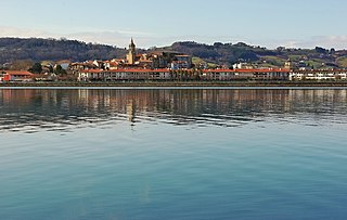
Hondarribia is a town situated on the west shore of Bidasoa river's mouth, in Gipuzkoa, in Basque Country, Spain.

Gipuzkoa is a province of Spain and a historical territory of the autonomous community of the Basque Country. Its capital city is Donostia-San Sebastián. Gipuzkoa shares borders with the French department of Pyrénées-Atlantiques at the northeast, with the province and autonomous community of Navarre at east, Biscay at west, Álava at southwest and the Bay of Biscay to its north. It is located at the easternmost extreme of the Cantabric Sea, in the Bay of Biscay. It has 66 kilometres of coast land.

Aia is a village situated on the slopes of Mount Pagoeta in the Basque province of Gipuzkoa, Spain. It is located 30 km to the west of Donostia-San Sebastián and about 10 km inland from the coastal town of Zarautz. Aia is set amongst hills and forests, and surrounded by mountains. The town has a large church, the Church of San Esteban, which includes a notable centrepiece. The population of Aia has gradually declined since the 1950s, to a population of 1,750 in 2005.

Lazkao is a town and municipality located in the Goierri region of the province of Gipuzkoa, in the Basque Country.

Mutriku is a coastal town located in the province of Gipuzkoa in the Autonomous Community of Basque Country in northern Spain. It has a population of around 5000 and provides access to the Bay of Biscay. It is the site of the world's first multi-turbine breakwater wave power station, opened July 8, 2011. The Church of San Andrés can be found here, being one of the oldest churches in Gipuzkoa, dating to the year 1080.

Orio is a fishing town located in the province of Gipuzkoa in the Basque Autonomous Community, northern Spain, with the town nucleus lying on the river Oria, roughly one mile away from its mouth by the Bay of Biscay. Orio had a population of 5,901 inhabitants as of 2016.

Usurbil is a town and region located in the province of Gipuzkoa in the Autonomous Community of the Basque Country, in the North of Spain.

Getaria is a town on the Urola coast, in the province of Gipuzkoa, in the autonomous community of the Basque Country, in northern Spain. It borders Zarautz to the east and Zumaia to the west.

Deusto, also known as Deustu in Basque and formerly known as San Pedro de Deusto, is one of the eight districts of Bilbao, Spain. It is located on the right side of the Bilbao estuary, in the northwestern part of the city and bordering the estuary itself on the south and the southern hillside of Mount Artxanda and Mount Bandera on the north. Deusto was originally an elizate and also a municipality until 1925 when it was completely annexed by Bilbao in order to expand the free land available to the city. Deusto is known as the university district of the city as it is home to the University of Deusto and the Faculty of Economics and Business of the University of the Basque Country.

San Sebastián Airport is the airport serving San Sebastián in Basque Country, Spain. Despite its name, the facilities are located in the municipality of Hondarribia, with the runway stretching like a spit of land along the river Bidasoa right on the Spanish–French border.

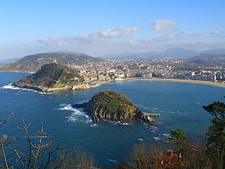
San Sebastián, officially known by the bilingual name Donostia / San Sebastián, is a city and municipality located in the Basque Autonomous Community, Spain. It lies on the coast of the Bay of Biscay, 20 km from the France–Spain border. The capital city of the province of Gipuzkoa, the municipality's population is 188,102 as of 2021, with its metropolitan area reaching 436,500 in 2010. Locals call themselves donostiarra (singular), both in Spanish and Basque. It is also a part of Basque Eurocity Bayonne-San Sebastián.

The Basque witch trials of the seventeenth century represent the last attempt at rooting out supposed witchcraft from Navarre by the Spanish Inquisition, after a series of episodes erupted during the sixteenth century following the end of military operations in the conquest of Iberian Navarre, until 1524.

Basque Y is the high-speed rail network being built between the three cities of the Basque Autonomous Community, in Spain; Bilbao, Vitoria-Gasteiz and Donostia-San Sebastián.

A trainera is a traditional boat of the Cantabrian Sea coast at the southern end of the Bay of Biscay, propelled by oars, and formerly sailing. It is a boat of fine lines with raised prow and rounded stern, to resist the waves of the Cantabrian sea. Traineras were originally used by fishermen to bring in the day’s catch of anchovies and sardines from sea to market, usually competing to sell their caught fish before others came in. Today, this historical tradition has become a major sport of coastal boat racing.
The Kontxako Bandera (Basque) or Bandera de la Concha is one of the oldest and most famous estropada race along the Bay of Biscay, held annually in the Kontxa, the main bay of San Sebastián, Spain. It takes place on the first two weekends in September and regularly draws crowds of more than 100,000 people and around 20 rowing teams. It was first held in 1879 and has been held most years since with the main exception of the war years.

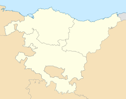
The Basque Autonomous Community [ A.C.] also officially called Euskadi [] is an autonomous community in northern Spain. It includes the Basque provinces of Araba, Bizkaia, and Gipuzkoa. It also surrounds an enclave called Treviño.

Jaizkibel is a mountain range of the Basque Country located east of Pasaia, north of Lezo and west of Hondarribia, in Spain, with 547 m (1,795 ft) at the highest point. The range stretches south-west to north-east, where it plunges into the sea at the Cape Higuer. To the north-west, the mountain dips its slopes in the sea with beautiful cliffs all along, overlooking on the east the marshes of Txingudi, the river Bidasoa and its mouth as well as the towns of Irun, Hendaia and Hondarribia on the riverbanks. The nearest relevant mountains are La Rhune, Aiako Harria and Ulia, closing the view east to west from the south. Some people consider Jaizkibel to be the first westernmost mountain of the Pyrenees.

Mount Ulia is a minor ridge located east of San Sebastian in the Basque Country, territory of Spain, reaching 243 m at its highest point. The ridge stretching out to the east along the coastline sinks in the strait leading to the bay of Pasaia. The chain overlooks San Sebastian to the west, with the Zurriola beach and the district of Gros lying right at the foot. This privileged location turned Mount Ulia into a significant leisure and romantic area in the early 20th century, a condition in which it has remained until now, despite the pressure of urban development.