Kristiansund is a municipality on the western coast of Norway in the Nordmøre district of Møre og Romsdal county. The administrative center of the municipality is the town of Kristiansund, which is the major town for the whole Nordmøre region. Other notable settlements in the municipality include the villages of Kvalvåg, Rensvik, and Nedre Frei.
Ertholmene is a small archipelago in Denmark. The largest island is Christiansø, whose name is often used with reference to the entire archipelago. Ertholmene are situated 18 kilometres (11 mi) northeast of Gudhjem, Bornholm, and include Denmark's easternmost point. Two of the islands, Christiansø and Frederiksø, are inhabited, with a combined permanent population of 91. The archipelago has a total area of 39 hectares. Its name is derived from the Danish for "pea islands".

Smøla is a municipality in Møre og Romsdal county, Norway. It is part of the Nordmøre region. The administrative centre of the municipality is the village of Hopen, other villages include Dyrnes, Råket, and Veiholmen.
Herøy is a municipality in Møre og Romsdal county, Norway. It is part of the Sunnmøre region. The administrative centre is the town of Fosnavåg on the island of Bergsøya. The industrial area of Eggesbønes is located south of Fosnavåg on the same island. The Runde Environmental Centre is located in the northern part of the municipality on Runde island. Other population centres in Herøy include the villages of Leikong, Kvalsund, or Moltustranda.
Averøy is a municipality in Møre og Romsdal county, Norway. It is part of the region of Nordmøre. The administrative centre of the municipality is the village of Bruhagen. Other villages in the municipality include Bremsnes, Kornstad, Kvernes, Kårvåg, Langøy, Sveggen, and Vebenstad.

The Atlantic Ocean Road or the Atlantic Road is an 8.3-kilometer (5.2 mi) long section of County Road 64 that runs through an archipelago in Hustadvika and Averøy municipalities in Møre og Romsdal county, Norway. It passes by Hustadvika, an unsheltered part of the Norwegian Sea, connecting the island of Averøy with the mainland and Romsdalshalvøya peninsula. It runs between the villages of Kårvåg in Averøy and Vevang in Hustadvika. It is built on several small islands and skerries, which are connected by several causeways, viaducts and eight bridges—the most prominent being Storseisundet Bridge.
The Out Skerries are an archipelago of islets, some inhabited, in Shetland, Scotland, and are the easternmost part of Shetland. Locally, they are usually called Da Skerries or just Skerries.
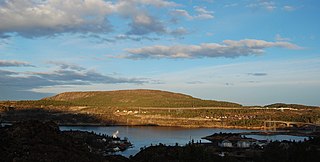
Kvernberget is a barren mountain formation with a maximum elevation of 205 metres (673 ft). The mountain is located on the island of Nordlandet on the western edge of the town of Kristiansund in Kristiansund Municipality in Møre og Romsdal county, Norway. Kristiansund Airport, Kvernberget, which sits nearby, takes its name from the mountain.

Grip Stave Church is a historic parish church of the Church of Norway in Kristiansund Municipality in Møre og Romsdal county, Norway. It is located in the now-abandoned fishing village of Grip on the small island of Grip about 14 kilometres (8.7 mi) northwest of the town of Kristiansund. It is an annex church for the Kristiansund parish which is part of the Ytre Nordmøre prosti (deanery) in the Diocese of Møre. The white, wooden church was built in a rectangular stave church style in 1470 by an unknown architect.

The Stockholm Archipelago is the largest archipelago in Sweden, and the second-largest archipelago in the Baltic Sea. Part of the archipelago has been designated as a Ramsar site since 1989.
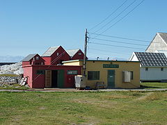
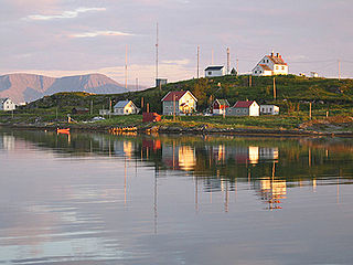
Veiholmen is a fishing village located on a group of tiny islands in the northern part of Smøla Municipality in Møre og Romsdal county, Norway. The island is located at the end of a 7-kilometre (4.3 mi) long road leading north from the village of Hopen. The road goes over many islands connecting Veiholmen to the island of Smøla to the south. In 2015, the village had the population of 212. Haugjegla Lighthouse is located about 1 kilometre (0.62 mi) north of Veiholmen on a small skerry.

Hovden is a fishing village in Bø Municipality in Nordland county, Norway. The village is located at the northern tip of a peninsula on the island of Langøya, on the west side of the Malnesfjorden. The ocean lies to the north and west of the village. The road that goes to Hovden ends at the village. The habitation of Hovden, on the outermost point on a peninsula of the third-largest island in Norway (Langøya) is because of the closeness to the rich fishing banks off of the Vesterålen archipelago. Fish processing and fishing are the main employment of dwellers in Hovden.

Halten is an unpopulated fishing village in the municipality of Frøya in Trøndelag county, Norway. The village was located on several adjacent islands at the far northern end of the Froan island chain. They constituted the northernmost part of the string of islands north of Frøya, which stretch from Sula in the south to Halten in the north. Halten Lighthouse is located on the island of Halten in the central part of the fishing village. The fishing village primarily was located on the islands of Husøya, Halten, Steinsøya, and Rorsøya. A large breakwater was built to protect the harbour area of the village. The village has had no permanent residents since 1988, but during the summers there are many vacationers and tourists.
Torsvåg is a fishing village on the far northwestern coast of Vannøya island in Karlsøy Municipality in Troms county, Norway. The nearest city is Tromsø about 90 kilometres (56 mi) southwest of Torsvåg. There is much archeological evidence that show that there has been settlements in Torsvåg since the Stone Age.

The Grip Lighthouse is located in the Grip archipelago in the municipality of Kristiansund in Møre og Romsdal county, Norway. The lighthouse was built between 1885 and 1888 on the 7-metre (23 ft) high islet of Bratthårskollen, north of Gripholmen.

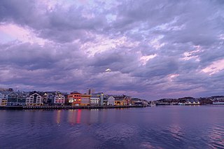
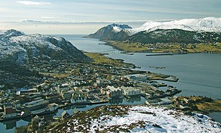
Kristiansund is a town in Kristiansund Municipality in Møre og Romsdal county, Norway. The town is the administrative centre of the municipality. it is located on the islands of Kirkelandet, Innlandet, and Nordlandet in the Nordmøre region of the county.

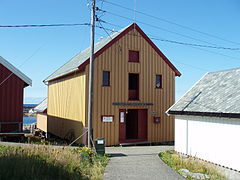
Bremsnes Church is a parish church of the Church of Norway in Averøy Municipality in Møre og Romsdal county, Norway. It is located in the village of Bremsnes on the eastern coast of the island of Averøya, just west of the town of Kristiansund. It is the church for the Bremsnes parish which is part of the Ytre Nordmøre prosti (deanery) in the Diocese of Møre. The white, wooden church was built in a cruciform style in 1771 by an unknown architect. The church seats about 350 people.

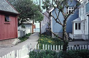
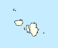
Grip is a former municipality in Møre og Romsdal county, Norway. With a land area of only 0.48 square kilometres and a population of 104, Grip was the smallest municipality in Norway during its existence from 1897 until it merged with Kristiansund in 1964. Grip municipality included all the islands in the Grip archipelago. The administrative centre of the municipality was the one fishing village in the municipality, known as Gripholmen, where the historic Grip Stave Church is located.

Sør-Gjæslingan is an archipelago in Nærøysund Municipality in Trøndelag county, Norway. The island group is located in at the entrance to the Folda fjord, about 25 kilometres (16 mi) to the southwest of the town of Rørvik and about 13 kilometres (8.1 mi) to the southeast of the Nordøyan islands.

Nordøyan is an archipelago and abandoned fishing village in Nærøysund Municipality in Trøndelag county, Norway. The island group is located at the western end of the Folda fjord, about 10 kilometres (6.2 mi) to the southwest of the island of Ytter-Vikna and about 13 kilometres (8.1 mi) to the northwest of the Sør-Gjæslingan islands. Nordøyan has been the site of a fishing village dating back to the 16th century, but since 1919, has not had any permanent residents. The homes on Nordøyan are now mostly used as holiday cottages.