Orio | |
|---|---|
Municipality | |
 View of Orio | |
 Coat of arms | |
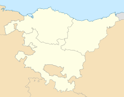 Orio Location of Orio within the Basque Country  Orio Location of Orio within Spain | |
| Coordinates: 43°16′41″N2°07′34″W / 43.278°N 2.126°W | |
| Country | |
| Autonomous community | |
| Province | Gipuzkoa |
| Comarca | Urola Kosta |
| Government | |
| • Mayor | Anuska Esnal Oliden |
| Area | |
• Total | 9.81 km2 (3.79 sq mi) |
| Elevation | 1 m (3 ft) |
| Population (2024) [1] | |
• Total | 6,182 |
| • Density | 630/km2 (1,600/sq mi) |
| Time zone | UTC+1 (CET) |
| • Summer (DST) | UTC+2 (CEST) |
| Postal code | 20810 |
| Website | www.orio.eus/ |

Orio is a fishing town located in the province of Gipuzkoa in the Basque Autonomous Community, northern Spain, with the town nucleus lying on the river Oria, roughly one mile away from its mouth by the Bay of Biscay. Orio had a population of 5,901 inhabitants as of 2016.
Contents
Traditionally a town attached to the sea and the fishing industry, this sector is losing ground to the more profitable and less demanding tourism, rapidly developing after marshes between the town and the beach were drained with a view to building up new tourist oriented housing. The most widely known and conspicuous sport activity in Orio is the rowing regatta typical of the Basque and Cantabric coastal area, featuring a team represented by the yellow colour.
The town is served by Euskotren Trena's coastal line, the N-634 road and the A-8 motorway (since 2010).
A festival representing the last catch of North Atlantic right whales within Basque whaling in 1901, have been held on every 5 years. [2] This catch also reflected in a folk poem popularized by singer-songwriter Benito Lertxundi. [3]


