Lasarte-Oria | |
|---|---|
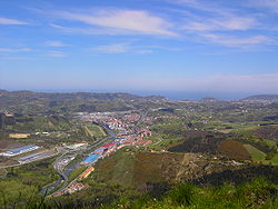 View of the town from the south (at Buruntza mountain) | |
 Coat of arms | |
 Lasarte-Oria Location in Spain | |
| Coordinates: 43°16′04″N2°01′12″W / 43.26778°N 2.02000°W | |
| Country | Spain |
| Autonomous community | Basque Country |
| Area | |
• Total | 601 km2 (232 sq mi) |
| Population (2024-01-01) [1] | |
• Total | 19,312 |
| • Density | 32.1/km2 (83.2/sq mi) |
| Time zone | UTC+1 (CET) |
| • Summer (DST) | UTC+2 (CEST) |
| Website | www.lasarte-oria.eus |
Lasarte-Oria is a town located in the province of Gipuzkoa, in the Autonomous Community of Basque Country, northern Spain. It was founded in 1986. It is estimated to have a population of around 19,000 people inhabitants.

