Aia

Last updated • 3 min readFrom Wikipedia, The Free Encyclopedia
Aia
Aiako kasko 1.jpg
Aia
Escudo de Aia.svg
Basque Country location map.svg
Red pog.svg
Aia
Location of Aia within the Basque Autonomous Community
Spain location map with provinces.svg
Red pog.svg
Aia
Aia (Spain)
Coordinates: 43°14′12″N2°08′55″W / 43.23667°N 2.14861°W / 43.23667; -2.14861
CountryFlag of Spain.svg  Spain
Autonomous community Flag of the Basque Country.svg  Basque Country
Province Gipuzkoa
Comarca Urola Kosta
Population
 (2018) [1]
  Total
2,081
Time zone UTC+1 (CET)
  Summer (DST) UTC+2 (CEST)
Postal code
20809
Dialing code 34 (Spain) + 943 (Gipuzkoa)
Website Official website

Aia ( /ˈ.ə/ ; Basque: [ai.a] ) is a village situated on the slopes of Mount Pagoeta in the Basque province of Gipuzkoa, Spain. It is located 30 km to the west of Donostia-San Sebastián and about 10 km inland from the coastal town of Zarautz. Aia is set amongst hills and forests, and surrounded by mountains. The town has a large church, the Church of San Esteban, which includes a notable centrepiece.[ citation needed ] The population of Aia has gradually declined since the 1950s, to a population of 1,750 in 2005.

Contents

History

Based on cave paintings and engravings and also stone implements that have been found in the Aia district, it is believed that human habitation of the area dates back to over 10,000 years ago. The town of Aia itself was mentioned in one of the oldest documents of Gipuzkoa dated 1025. The town was also mentioned as being part of the Union of Sayaz in the Decree of the Brotherhood of the Province of Gupuzkoa in 1375.

Farming was originally the main economic activity in the Aia district, with families of the small villages living within closed, self-sufficient economic systems. Land was generally owned by the municipality and rented to the farmers to work. Specialised crafts also began to develop, and in particular Aia became a main centre for the production of iron. This was largely due to the abundance of natural deposits of iron in the area. Numerous foundries were established in the area, which had a significant impact on the growth of the local population. It was from these foundries that many family lineages in the Aia district developed. The demise of these old forges in Guipúzcoa was brought about by the introduction of blast furnaces that ran on coal.

Tourism

Aia is situated within Basque farmlands, and largely unchanged over several hundred years.[ citation needed ] It has several tourist attractions, including the 1,335-acre (5.40 km2) Pagoeta Nature Reserve which sits to the west of the town of Aia and preserves the natural environment of the area, as well as the district's cultural heritage.[ citation needed ] The park contains a number of ruins of old mills, foundries, and farmhouses, and some ancient burial mounds dating back 5,000 years.

Agorregi Forge, near Aia, Gipuzkoa Province Agorregi gipuzkoa.jpg
Agorregi Forge, near Aia, Gipuzkoa Province

The Agorregi Forge , located within the park, is one of the best preserved examples of a foundry in Gipuzkoa province.[ citation needed ] The forge which can be seen today was built in 1754 by the Lord of Laurgain Palace over the ruins of an earlier version. Lying at the bottom of a deep valley near Manterola farmhouse, it used the river's hydraulic energy to power its bellows and turn its waterwheels.

Also situated near Aia and within the Pagoeta Nature Reserve is the Iturraran Botanic Garden. The garden was established in 1986 and includes more than 1,000 species of plants, trees, and shrubs from all over the world. It also includes some endangered flora of the Basque Country.

Geographic distribution

Aia is a municipality formed by a principal nucleus – the town of Aia – and its neighbourhoods, which resemble small villages. It comprises eleven neighbourhoods:

The urban nucleus of Aia has about 470 inhabitants.

Related Research Articles

<span class="mw-page-title-main">Hondarribia</span> Municipality in Basque Country, Spain

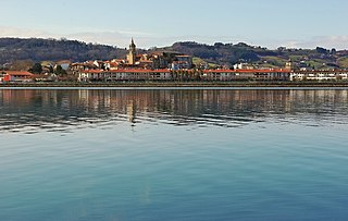
Hondarribia is a town situated on the west shore of Bidasoa river's mouth, in Gipuzkoa, in the Basque Autonomous Community.

<span class="mw-page-title-main">Eibar</span> Municipality in Euskadi, Spain

Eibar is a city and municipality within the province of Gipuzkoa, in the Autonomous Community of Euskadi. It is the capital of the eskualde / comarca of Debabarrena.

<span class="mw-page-title-main">Gipuzkoa</span> Province of Spain

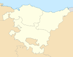
Gipuzkoa is a province of Spain and a historical territory of the autonomous community of the Basque Country. Its capital city is Donostia-San Sebastián. Gipuzkoa shares borders with the French department of Pyrénées-Atlantiques at the northeast, with the province and autonomous community of Navarre at east, Biscay at west, Álava at southwest and the Bay of Biscay to its north. It is located at the easternmost extreme of the Cantabric Sea, in the Bay of Biscay. It has 66 kilometres of coast land.

<span class="mw-page-title-main">Tolosa, Spain</span> Municipality in Basque Country, Spain

Tolosa is a town and municipality in the Basque province of Gipuzkoa, in northern Spain. It is located in the valley of the river Oria, next by Uzturre, a local mountain topped by a white cross.

<span class="mw-page-title-main">Alkiza</span> Place in Basque Country, Spain

Alkiza is a rural municipality in the centre of Gipuzkoa, northwest of the Tolosaldea County, in the Basque Country. It is 27 kilometres south of San Sebastian. In 2019 it had 373 inhabitants, of which 88.8% were Basque speakers. Alkiza is an independent municipality since 1731; previously it depended on Tolosa and San Sebastian.

<span class="mw-page-title-main">Leintz Gatzaga</span> Municipality in Basque Country, Spain

Leintz Gatzaga is a town located in the province of Gipuzkoa, in the Autonomous Community of Basque Country, northern Spain. The municipality's population is 251 (2015).

<span class="mw-page-title-main">Oiartzun</span> Municipality in Basque Country, Spain

Oiartzun is a town and municipality located in the Basque Country, in the province of Gipuzkoa lying at the foot of the massif Aiako Harria.

<span class="mw-page-title-main">Orio, Spain</span> Municipality in Basque Country, Spain

Orio is a fishing town located in the province of Gipuzkoa in the Basque Autonomous Community, northern Spain, with the town nucleus lying on the river Oria, roughly one mile away from its mouth by the Bay of Biscay. Orio had a population of 5,901 inhabitants as of 2016.

<span class="mw-page-title-main">Usurbil</span> Municipality in Basque Country, Spain

Usurbil is a town and region located in the province of Gipuzkoa in the Autonomous Community of the Basque Country, in the North of Spain.

<span class="mw-page-title-main">Elorrio</span> Municipality in Basque Country, Spain

Elorrio is a town and a municipality located in the eastern part of the province of Biscay, in the Basque Country, in northern Spain. As of 2017, it has a population of 7,307 inhabitants. It covers an area of 37.20 square kilometers and it has a population density of 193.58 people per square kilometer. It holds the medieval title of Most Loyal and Noble Villa.

<span class="mw-page-title-main">Getxo</span> Municipality in Basque Country, Spain

Getxo is a town located in the province of Biscay, in the autonomous community of the Basque Country, in Spain. It is part of Greater Bilbao, and has 75,430 inhabitants (2023). Getxo is mostly an affluent residential area, as well as being the third largest municipality of Biscay.

<span class="mw-page-title-main">Loiu</span> Municipality in Basque Country, Spain

Loiu is a town and municipality located in the province of Biscay, in the autonomous community of Basque Country, northern Spain.

<span class="mw-page-title-main">Agurain/Salvatierra</span> Municipality in Basque Country, Spain

Agurain in Basque or Salvatierra in Spanish, officially Agurain/Salvatierra, is a town and municipality located in the province of Álava in the Basque Autonomous Community, northern Spain. The municipality has a population of 5,155 inhabitants as of 2024 and is the most populous town in the cuadrilla of Llanada Alavesa.

<span class="mw-page-title-main">Banca, Pyrénées-Atlantiques</span> Commune in Nouvelle-Aquitaine, France

Banca is a commune of the Pyrénées-Atlantiques department in the Nouvelle-Aquitaine region of south-western France. It is part of the former province of Lower Navarre.

<span class="mw-page-title-main">Hernani, Spain</span> Municipality in Basque Country, Spain

Hernani is a town and municipality located in the province of Gipuzkoa, Basque Autonomous Community, Spain. The town sits on the left bank of the Urumea river. It is located at a distance of 9.2 km from San Sebastián. The municipality of Hernani occupies an area of approximately 40 square kilometres and is bordered by San Sebastián, Astigarraga, Arano, Elduayen, Errenteria, Lasarte-Oria and Urnieta.

<span class="mw-page-title-main">San Sebastián</span> City in the Basque Autonomous Community, Spain

San Sebastián, officially known by the bilingual name Donostia / San Sebastián, is a city and municipality located in the Basque Autonomous Community, Spain. It lies on the coast of the Bay of Biscay, 20 km from the France–Spain border. The capital city of the province of Gipuzkoa, the municipality's population is 188,102 as of 2021, with its metropolitan area reaching 436,500 in 2010. Locals call themselves donostiarra (singular), both in Basque and Spanish. It is also a part of Basque Eurocity Bayonne-San Sebastián.

<span class="mw-page-title-main">Agorregi Forge</span>

The Agorregi Forge is located within the Pagoeta Nature Reserve, near the town of Aia, in the Basque Province of Gipuzkoa, Spain. It is one of the best preserved examples of a foundry in Gipuzkoa province. The forge which can be seen today is a built in 1754 by the lord of Laurgain Palace over the ruins of an earlier version. Lying at the bottom of a deep valley near Manterola farmhouse, it used the river's hydraulic energy to power its great bellows and turn its waterwheels.

<span class="mw-page-title-main">Pagoeta Natural Park</span> Spanish natural park

Pagoeta Natural Park is a park in Gipuzkoa, Basque Autonomous Community, Spain. Mount Pagoeta is closest to the villages of Aia and Laurgain, and near the coastal towns of Zarautz and Orio. The park features a park house, a museum, and picnic areas. Group guided tours are available.

<span class="mw-page-title-main">Debabarrena</span>

Debabarrena is an eskualdea / comarca located in Gipuzkoa, Basque Country (Spain). It has an area of 180,3 km2. It is north from the comarca of Debagoiena, east from the province of Biscay, and south from the Gulf of Biscay.

<span class="mw-page-title-main">Comarcas of the Basque Country</span>

The autonomous community of the Basque Country within Spain contains several comarcas or eskualdeak in the Basque language, referring to local districts, grouped into its three long-established provinces.

References

  1. Municipal Register of Spain 2018. National Statistics Institute.