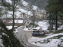
Legazpi is a city in the Gipuzkoa province of the Autonomous Community of the Basque Country, northern Spain.

Gipuzkoa is a province of Spain and a historical territory of the autonomous community of the Basque Country. Its capital city is Donostia-San Sebastián. Gipuzkoa shares borders with the French department of Pyrénées-Atlantiques at the northeast, with the province and autonomous community of Navarre at east, Biscay at west, Álava at southwest and the Bay of Biscay to its north. It is located at the easternmost extreme of the Cantabric Sea, in the Bay of Biscay. It has 66 kilometres of coast land.

Aia is a village situated on the slopes of Mount Pagoeta in the Basque province of Gipuzkoa, Spain. It is located 30 km to the west of Donostia-San Sebastián and about 10 km inland from the coastal town of Zarautz. Aia is set amongst hills and forests, and surrounded by mountains. The town has a large church, the Church of San Esteban, which includes a notable centrepiece. The population of Aia has gradually declined since the 1950s, to a population of 1,750 in 2005.
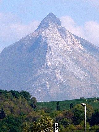
Txindoki or Larrunarri is an iconic mountain located in the region of Goierri, Gipuzkoa, in the Basque Autonomous Community of Spain. Originally Larrunarri or Ñañarri, the mount took on the popularized name Txindoki by extension after some shepherd huts nearby. It is sometimes referred to as the Basque Matterhorn too, because of its pyramidal shape.
The Urola is a river and valley in Gipuzkoa, Basque Autonomous Community, Spain.

Andoain is a town in the province of Gipuzkoa, in the autonomous community of Basque Country, in the North of Spain. Nowadays it has a population of 14,637 inhabitants (2019), which has been quite stable since the 90s.

Orio is a fishing town located in the province of Gipuzkoa in the Basque Autonomous Community, northern Iberia, with the town nucleus lying on the river Oria, roughly one mile away from its mouth by the Bay of Biscay. Orio had a population of 5,901 inhabitants as of 2016.

Usurbil is a town and region located in the province of Gipuzkoa in the Autonomous Community of the Basque Country, in the North of Spain.
Amasa-Villabona is a village of over 5500 inhabitants in the comarca of Tolosaldea, Gipuzkoa province, Basque Country, Spain. It has an urban area, Villabona, close to the Oria River, and a rural area, Amasa, around which the village originally formed. Amasa-Villabona is located in the Oria Valley, in the foothills of Mount Gazume and Mount Uzturre. It is about 20 kilometres (12 mi) from the provincial capital, San Sebastián.

Hernani is a town and municipality located in the province of Gipuzkoa, Basque Autonomous Community, Spain. The town sits on the left bank of the Urumea river. It is located at a distance of 9.2 km from San Sebastián. The municipality of Hernani occupies an area of approximately 40 square kilometres and is bordered by San Sebastián, Astigarraga, Arano, Elduayen, Errenteria, Lasarte-Oria and Urnieta.

The Leitzaran is a river and a valley in the Navarre and the Basque Country (Spain). It flows into the river Oria from its right.

Aizkorri or Aitzgorri is a massif, the highest one of the Basque Autonomous Community (Spain) with 1,551 m AMSL at its highest point. The massif is formed by a crest of limestone summits aligned north-west to south-east all in a row at the south of the province of Gipuzkoa, namely Artzanburu, Andreaitz, Arbelaitz (1,513 m), Iraule (1,511 m), Aitxuri, Aketegi (1,549 m) and Aizkorri (1,528 m). Despite its slightly lower height, this summit is the most popular one. The Aizkorri massif is one of the most conspicuous geological formations on the Basque Mountains range.
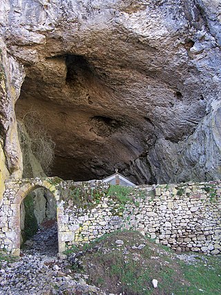
The San Adrian tunnel or Lizarrate represents the most outstanding milestone in the historic inland Basque route of the Way of St. James. It consists of a natural cave carved by water erosion in the rock with an opening on either side north and south; it also holds an hermitage inside. The tunnel provides a natural passage dividing the provinces of Gipuzkoa and Álava/Araba.

Aratz is a mountain of the Basque Country in Spain located at the mountain range Altzania that provides the extension for the massif Aizkorri. It lies right on the line between provinces Gipuzkoa and Álava, the summit rising at 1,443 m high, next to Elurzuloak. The whole Aizkorri and Aratz area was declared the Aizkorri-Aratz Natural Park in 2006.

Adarra is a mountain south of the city of San Sebastian in the Basque Country. It is a popular peak with the local residents. The mountain is flanked on the north by the minor summits of Oindi or Onddi and Onddo to the south, all of them located at the top of a long mountain range of modest height between the Urumea and Leitzaran valleys, which extends south right to the edge of the Navarrese town of Leitza.
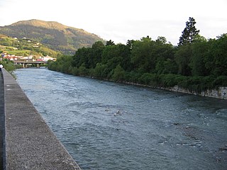
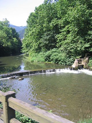
The Oria is a river in the Basque Country at the north of the Iberian Peninsula. It's one of a series of Basque rivers flowing into the Bay of Biscay and the main river of the province Gipuzkoa in volume, length (75 km) and basin (882.5 km2), the main feature of these rivers aligned south to north being their shortness. The maximum elevation at the source is 1,260 m, while at its lowest height the tidal influence extends inland up to Usurbil (estuary). On this final stretch, many marsh and wetland strips dotted the banks of the Oria, although some of them have been drained for agricultural and building purposes.

The Basque Country, also called the Basque Autonomous Community, is an autonomous community in northern Spain. It includes the Basque provinces of Álava, Biscay, and Gipuzkoa. It also surrounds an enclave called Treviño, which belongs to the neighboring autonomous community of Castile and León.

The physical geography of the Basque Country is very diverse despite the small size of the region. The territory hosts a blend of green and brown to yellowish tones, featuring hilly terrain altogether. The Basque Country spreads from the rough coastal landscape to the semi-desert of the Bardenas on the south-eastern fringes of Navarre.
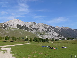
The Aizkorri-Aratz Natural Park is the second-largest natural park in the Basque Country. Straddling the Cantabrian-Mediterranean watershed, it is named Aizkorri and Aratz, the two most notable mountains in the park. Declared a natural park in 2006, the area contains limestone mountains and as well as dense beech forests.

The autonomous community of the Basque Country within Spain contains several comarcas or eskualdeak in the Basque language, referring to local districts, grouped into its three long-established provinces.