Biscay is a province of Spain and a historical territory of the Basque Country, heir of the ancient Lordship of Biscay, lying on the south shore of the eponymous bay. The capital and largest city is Bilbao.

The Basque Country is the name given to the home of the Basque people. The Basque Country is located in the western Pyrenees, straddling the border between France and Spain on the coast of the Bay of Biscay.

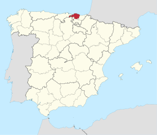
Gipuzkoa is a province of Spain and a historical territory of the autonomous community of the Basque Country. Its capital city is Donostia-San Sebastián. Gipuzkoa shares borders with the French department of Pyrénées-Atlantiques at the northeast, with the province and autonomous community of Navarre at east, Biscay at west, Álava at southwest and the Bay of Biscay to its north. It is located at the easternmost extreme of the Cantabric Sea, in the Bay of Biscay. It has 66 kilometres of coast land.
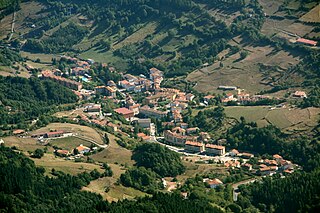
Zegama, popularly known as "the shadow of Aizkorri", is a town and municipality in the Goierri region of the province of Gipuzkoa, in the autonomous community of the Basque Country, northern Spain.
The Cantabrian Mountains or Cantabrian Range are one of the main systems of mountain ranges in Spain. They stretch for over 300 km (180 miles) across northern Spain, from the western limit of the Pyrenees to the Galician Massif in Galicia, along the coast of the Cantabrian Sea. Their easternmost end meets the Sistema Ibérico.
Cantabrian Coast is the name given to a lush natural region in Northern Spain, stretching along the Atlantic coast from the border with Portugal to the border with France. The region includes nearly all of Galicia, Asturias, and Cantabria, in addition to the northern parts of the Basque Country, as well as a small portion of Navarre.

The Basque Mountains are a mountain range situated in the northern Iberian Peninsula. Geographically the range is considered as the eastern section of the larger Cantabrian Range. The range runs through the Basque Autonomous Community and western Navarre.

The Sanctuary of Our Lady of Arantzazu is a Franciscan sanctuary located in Oñati, Basque Country, Spain. The shrine is a much appreciated place among Gipuzkoans, with the Virgin of Arantzazu being the sanctuary's namesake and patron saint of the province along with Ignatius of Loyola.

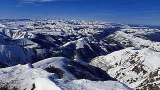
Aizkorri or Aitzgorri is a massif, the highest one of the Basque Autonomous Community (Spain) with 1,551 m AMSL at its highest point. The massif is formed by a crest of limestone summits aligned north-west to south-east all in a row at the south of the province of Gipuzkoa, namely Artzanburu, Andreaitz, Arbelaitz (1,513 m), Iraule (1,511 m), Aitxuri, Aketegi (1,549 m) and Aizkorri (1,528 m). Despite its slightly lower height, this summit is the most popular one. The Aizkorri massif is one of the most conspicuous geological formations on the Basque Mountains range.
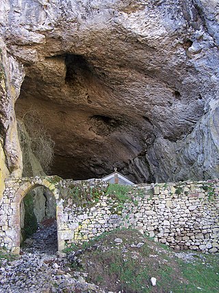
The San Adrian tunnel or Lizarrate represents the most outstanding milestone in the historic inland Basque route of the Way of St. James. It consists of a natural cave carved by water erosion in the rock with an opening on either side north and south; it also holds a hermitage inside. The tunnel provides a natural passage dividing the provinces of Gipuzkoa and Álava/Araba.

Aratz is a mountain of the Basque Country in Spain located at the mountain range Altzania that provides the extension for the massif Aizkorri. It lies right on the line between provinces Gipuzkoa and Álava, the summit rising at 1,443 m high, next to Elurzuloak. The whole Aizkorri and Aratz area was declared the Aizkorri-Aratz Natural Park in 2006.
The Aralar Range is a mountain range in the Basque Mountains of the Southern Basque Country. The part of the range lying in Gipuzkoa was established as a conservation area called Aralar Natural Park in 1994. In addition to its natural features, scenery, recreational use and habitation, the range is home to a number of Basque mythology milestones and legends.
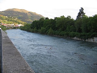
The Oria is a river in the Basque Country at the north of the Iberian Peninsula. It's one of a series of Basque rivers flowing into the Bay of Biscay and the main river of the province Gipuzkoa in volume, length (75 km) and basin (882.5 km2), the main feature of these rivers aligned south to north being their shortness. The maximum elevation at the source is 1,260 m, while at its lowest height the tidal influence extends inland up to Usurbil (estuary). On this final stretch, many marsh and wetland strips dotted the banks of the Oria, although some of them have been drained for agricultural and building purposes.
The Basque Country, also called the Basque Autonomous Community, is an autonomous community in northern Spain. It includes the Basque provinces of Álava, Biscay, and Gipuzkoa. It also surrounds an enclave called Treviño, which belongs to the neighboring autonomous community of Castile and León.

Urkiola Natural Park is a protected area located in the southeastern corner of Biscay and Álava in the northern Basque Country, Spain. It is a protected area of 5,958 hectares.

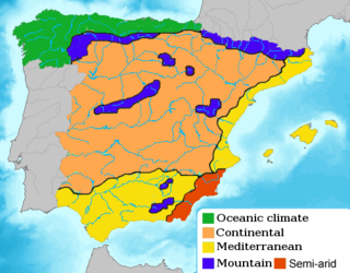
The physical geography of the Basque Country is very diverse despite the small size of the region. The territory hosts a blend of green and brown to yellowish tones, featuring hilly terrain altogether. The Basque Country spreads from the rough coastal landscape to the semi-desert of the Bardenas on the south-eastern fringes of Navarre.
Tourism in the Basque Autonomous Community has increased considerably in recent years, and is a popular destination for tourists from Spain and France. According to data from the Eustat the number of tourists entering the region in the year 2009 was 1,991,790, with the final result still pending. 71% of the yearly visitors come from the rest of Spain; the greatest number from Madrid Autonomous Community (14.2%), and Catalonia (11.1%). International visitors make up the remaining 29% - the largest percent come from France (7.2%). 62% of the people who come to the Basque Autonomous Community visit one of the three capitals, 27% visit inland and 11% visit the coast. The average stay of the visitors is 2 days.
Elgea-Urkilla eolic park is a wind farm in Spain which was authorized to be built on 23 August 1999 by the union of Iberdrola Ente Vasco and Sociedad de Eolicas de Euskadi, S.A. Its construction took 6 months and it is situated between Alava and Gipuzkoa, powering villages such as Barrundia, San Millan, Eskoriatza and Aretxabaleta. The park also reaches the limits of the Aizkorri-Aratz Natural Park. It fills 7 hectares, with 40 towers, twenty-seven of which are in Alava. The park's construction created a wide protest because of the site's impact.

Armentia is one of the villages associated with Vitoria-Gasteiz. Its name comes from the Latin word armentum, which translated into English means "intensive farming". The village is well known for its 161 hectare park created in 1998. The northern boundary of the village is formed by the Ariznavarra neighborhood.

The Sierra de Leyre or Sierra de Leire is a mountain range in Navarre (Spain). It is the first pre-Pyrenean mountain range and is located in the northeast of the Comunidad Foral. It is 30 km long and has an east–west orientation.


