
Cape Coast is a city, fishing port, and the capital of Cape Coast Metropolitan District and Central Region of Ghana. It is one of the country's most historic cities, a World Heritage Site, home to the Cape Coast Castle, with the Gulf of Guinea situated to its south. It was also the first capital of Ghana. According to the 2021 census, Cape Coast had a settlement population of 189,925 people. The language of the people of Cape Coast is Fante.

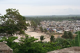
Axim is a coastal town and the capital of Nzema East Municipal district, a district in Western Region of South Ghana. Axim lies 64 kilometers west of the port city of Sekondi-Takoradi in the Western Region, west of Cape Three Points. Axim has a 2013 settlement population of 27,719 people.

The Western Region is located in south Ghana, spreads from the Ivory Coast in the west to the Central region in the east, includes the capital and large twin city of Sekondi-Takoradi on the coast, coastal Axim, and a hilly inland area including Elubo. It includes Ghana's southernmost location, Cape Three Points, where crude oil was discovered in commercial quantities in June 2007. The region covers an area of 13,842 km2, and had a population of 2,060,585 at the 2021 Census.

Sekondi-Takoradi is a city in Ghana comprising the twin cities of Sekondi and Takoradi. It is the capital of Sekondi-Takoradi Metropolitan District and the Western Region of Ghana. Sekondi-Takoradi is the region's largest city as well as an industrial and commercial center with a population of 104,847 people, according to the 2021 census. The current mayor of the city and the metropolitan as a whole is Hon. Abdul-Mumin Issah.

Elmina is a town and the capital of the Komenda/Edina/Eguafo/Abirem District on the south coast of Ghana in the Central Region. It is situated on a bay on the Atlantic Ocean, 12.2 km (7.6 mi) west of Cape Coast. Elmina was the first European settlement in West Africa and it has a population of 33,576 people, as of 2013. The current Municipality chief of Elmina is Hon. Solomon Ebo Appiah.
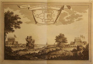
Princes Town or Pokesu is located 5 km east of Fort St. Antonio on Manfro Hill in the Ahanta West District of the Western Region of south Ghana, Africa. It lies between Axim to the west and Sekondi-Takoradi to the east. On 1 January 1681, a Brandenburger expedition of two ships commanded by Otto Friedrich von der Groeben arrived in the Gold Coast and began to build a strong fort between Axim and the Cape of Three Points. The fort was completed in 1683 and was named Fort Fredericksburg in honour of Prince Frederick William I, Elector of Brandenburg. Because the fort was named after a Prince, it has been referred to as Princes Town. The fort was to be the headquarters of the Brandenburgers in Africa.
John Canoe, also known as January Conny, was the European name given to an Akan warrior from Axim, Ghana. He was a chief of the Ahanta people in the early 18th century, who established a stronghold in the defunct Fort Fredericksburg and fought multiple wars with European traders for twenty years. The stronghold finally fell in 1725, though Canoe's fate is unknown. He is commemorated in the Junkanoo festival held in the Caribbean each December.

The Portuguese Gold Coast was a Portuguese colony on the West African Gold Coast along the Gulf of Guinea. Established in 1482, the colony was officially incorporated into Dutch territory in 1642. From their seat of power at the fortress of São Jorge da Mina, the Portuguese commanded a vast internal slave trade, creating a slave network that would expand after the end of Portuguese colonialism in the region. The primary export of the colony was gold, which was obtained through barter with the local population. Portuguese presence along the Gold Coast increased seamanship and trade in the Gulf, introduced American crops into the African agricultural landscape, and made Portuguese an enduring language of trade in the area.

Fort Prinzenstein is a fort located at Keta, Ghana, which was used in the slave trade. Many such forts were built in Africa, but Prinzenstein is one of the few that lie east of the Volta River. Keta served as an open port until the Tema Harbour commenced its operation to the west in 1962. The fort has been designated a World Heritage Site because of its historical importance and testimony to the Atlantic slave trade.

The Treaty of Butre between the Netherlands and Ahanta was signed at Butre, Dutch Gold Coast on 27 August 1656. The treaty regulated the jurisdiction of the Netherlands and the Dutch West India Company over the town of Butre and the surrounding country of Upper Ahanta, creating a Dutch protectorate over the area, and permitting the establishment of Fort Batenstein. The treaty lasted until the Dutch departure from the Gold Coast in April 1872.

Fort Patience is a Dutch-built fort located in the township of Apam, in the Central Region of Ghana. Originally built in 1697, it served as a defensive fortification and a trading post. Because of its testimony to European pre-colonial and colonial influence in West Africa, the fort was inscribed on the UNESCO World Heritage List along with several other forts and castles in Ghana.

Ada Foah is a town on the southeast coast of Ghana, where the Volta River meets the Atlantic Ocean. The town is located along the Volta River, off of the Accra-Aflao motorway. Known for palm-lined beaches and estuary islands, Ada Foah is also the capital of the Ada East District and the seat of the District Assembly.

Fort Saint Anthony was a fort built by the Portuguese in 1515 near the town of Axim, in what is now Ghana. In 1642, the Dutch captured the fort and subsequently made it part of the Dutch Gold Coast. The Dutch expanded the fort considerably before they turned it over, with the rest of their colony, to the British in 1872. The fort is now the property of the Ghanaian state and is open to the public.
Ussher Fort is a fort in Accra, Ghana. It was built by the Dutch in 1649 as Fort Crèvecœur, and is two days' march from Elmina and to the east of Accra on a rocky point between two lagoons. It was one of three forts that Europeans built in the region during the middle of the 17th century. Fort Crèvecœur was part of the Dutch Gold Coast. The Anglo-Dutch Gold Coast Treaty (1867), which defined areas of influence on the Gold Coast, transferred it to the British in 1868. Because of its significance in the history of European colonial trade and exploitation in Africa, the fort was inscribed on the UNESCO World Heritage List in 1979.

Fort Amsterdam is a former slave fort in Abandze, Central region, Ghana. It was built by the English between 1638 and 1645 as Fort Cormantin or Fort Courmantyne, and was captured by admiral Michiel de Ruyter of the Dutch West India Company in 1665, in retaliation for the capture of several Dutch forts by the English Admiral Holmes in 1664. It was subsequently made part of the Dutch Gold Coast, and remained part of it until the fort was traded with the British in 1868. The Fort is located at Abandze, on the north-east of Cape Coast in the Mfantseman District of the Central Region of Ghana. Because of its testimony to European economic and colonial influence in West Africa and its historical importance in the Atlantic slave trade, the fort was inscribed on the UNESCO World Heritage List in 1979 along with other forts and castles in Ghana.

Fort Batenstein was a fort and trading post established by the Dutch on the Gold Coast in 1656. It was situated near Butre. The fort was ceded with the entire Dutch Gold Coast to Britain in 1872.

Fort Orange was built as a trading post on the Dutch Gold Coast in 1642, near Sekondi in the Western Region of Ghana. It functioned as a lodge for a while during the 1670s and that was the original purpose for the fort before it was used as a trading post. The trading post was enlarged into a fort in 1690. It was joined by an English Fort Sekondi in 1682. It was sold with the rest of the Dutch Gold Coast to the United Kingdom in 1872, and now serves as a lighthouse. Because of its historical importance in trade between Europe and Africa, Fort Orange was inscribed on the UNESCO World Heritage List in 1979 along with several other castles and forts in Ghana.

Fort Metal Cross, originally Fort Dixcove, is a military structure located on a promontory at the fishing community of Infuma in Dixcove, in the Western Region of Ghana. Because of its history in the Atlantic slave trade and its testimony to European-African trade, the Fort was included as one of the Forts and Castles of Volta, Greater Accra, Central and Western Regions that became a World Heritage Site in 1979.


