


This is a list of fishing villages. A fishing village is a village, usually located near a fishing ground, with an economy based on catching fish and harvesting seafood.
This is a list of fishing villages. A fishing village is a village, usually located near a fishing ground, with an economy based on catching fish and harvesting seafood.

The Maritimes, also called the Maritime provinces, is a region of Eastern Canada consisting of three provinces: New Brunswick, Nova Scotia, and Prince Edward Island. The Maritimes had a population of 1,899,324 in 2021, which makes up 5.1% of Canada's population. Together with Canada's easternmost province, Newfoundland and Labrador, the Maritime provinces make up the region of Atlantic Canada.

A harbor, or harbour, is a sheltered body of water where ships, boats, and barges can be moored. The term harbor is often used interchangeably with port, which is a man-made facility built for loading and unloading vessels and dropping off and picking up passengers. Harbors usually include one or more ports. Alexandria Port in Egypt, meanwhile, is an example of a port with two harbors.

The Gulf of St. Lawrence fringes the shores of the provinces of Quebec, New Brunswick, Nova Scotia, Prince Edward Island, Newfoundland and Labrador, in Canada, plus the islands Saint-Pierre and Miquelon, possessions of France, in North America.

Poitou-Charentes was an administrative region on the southwest coast of France. It is part of the new region Nouvelle-Aquitaine. It comprised four departments: Charente, Charente-Maritime, Deux-Sèvres and Vienne. It included the historical provinces of Angoumois, Aunis, Saintonge and Poitou.

This is a comprehensive list of rivers, organized primarily by continent and country.

The 16th century in Canada saw the first contacts, since the Norsemen 500 years earlier, between the indigenous peoples in Canada living near the Atlantic coast and European fishermen, whalers, traders, and explorers.
Events from the year 1761 in Canada.
The following are the regional bird lists by continent.

Marine Atlantic Inc. is an independent Canadian federal Crown corporation which is mandated to operate ferry services between the provinces of Newfoundland and Labrador and Nova Scotia.

Labourd is a former French province and part of the present-day Pyrénées Atlantiques département of Nouvelle-Aquitaine region. It is one of the traditional Basque provinces, and identified as one of the territorial component parts of the Basque Country by many, especially by the Basque nationalists.

Channel-Port aux Basques is a town at the extreme southwestern tip of Newfoundland fronting on the western end of the Cabot Strait. A Marine Atlantic ferry terminal is located in the town which is the primary entry point onto the island of Newfoundland and the western terminus of the Newfoundland and Labrador Route 1 in the province. The town was incorporated in 1945 and its population in the 2021 census was 3,547.

Placentia is a town located in the Canadian province of Newfoundland and Labrador. It consists of the amalgamated communities of Placentia ("Townside"), Southeast Placentia, Freshwater, Dunville and Jerseyside and also includes the Argentia Industrial Park.
The history of Saint Pierre and Miquelon is one of early settlement by Europeans taking advantage of the rich fishing grounds near Saint-Pierre and Miquelon, and is characterized by periods of conflict between the French and British.

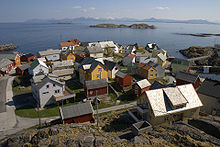
Burnt Islands is a small coastal community found in God Bay on the southwest coast of Newfoundland, Canada.

Franco-Newfoundlanders, also known as Franco-Terreneuvians in English or Franco-Terreneuviens in French, are francophone and/or French Canadian residents of the Canadian province of Newfoundland and Labrador. The name Franco-Terreneuvian derives from Terre-Neuve, the French name of Newfoundland.

Newfoundland is a large island within the Canadian province of Newfoundland and Labrador. It is situated off the eastern coast of the North American mainland and the geographical region of Labrador.
Captain Savalette was a Basque ship's captain who, in 1607, reportedly had been fishing off Canso, Nova Scotia since 1565.

The settlement of Basques in the Americas was the process of Basque emigration and settlement in the New World. Thus, there is a deep cultural and social Basque heritage in some places in the Americas, the most famous of which being Saint Pierre and Miquelon, Central America, Guatemala and Antioquia, Colombia.

