Chibu, Shimane

Last updated • 2 min readFrom Wikipedia, The Free Encyclopedia
Chibu
知夫村
Village
Flag of Chibu, Shimane.svg
Emblem of Chibu, Shimane.svg
Chibu in Shimane Prefecture Ja.svg
Location of Chibu in Shimane Prefecture
Japan location map with side map of the Ryukyu Islands.svg
Red pog.svg
Chibu
Location of Chibu in Japan
Coordinates: 36°0′51.14″N133°2′22.55″E / 36.0142056°N 133.0395972°E / 36.0142056; 133.0395972
Country Japan
Region Chūgoku
San'in
Prefecture Shimane Prefecture
District Oki
Settled2000 BCE
Incorporated (district)600 CE
Incorporated (village)600 CE
Neighborhoods
List
  • Kōri ()
  • Nibu (仁夫)
  • Ōe (大江)
  • Tataku (多沢)
  • Usuge (薄毛)
  • Kurii (来居)
  • Urumi (古海)
Area
[1]
  Total13.70 km2 (5.29 sq mi)
  Land13.70 km2 (5.29 sq mi)
Highest elevation
325 m (1,066 ft)
Population
 (2010) [2]
  Total657
  Estimate 
(March 2011 [3] )
656
  Density48/km2 (120/sq mi)
Time zone UTC+9 (Japan Standard Time)
Postal code
684-0100
Phone08514-8-2211
Address1065 Kōri, Chibu-mura, Oki-gun, Shimane-ken 684-0102
Address (Japanese)〒684-0102島根県隠岐郡知夫村郡1065番地
Website www.vill.chibu.lg.jp

Chibu (知夫村, Chibu-mura, Chibu-son) is a village located on Chiburijima (知夫里島) in the Dōzen group of islands in the Oki District, Shimane Prefecture, Japan. Chibu is the only village remaining in Shimane Prefecture as of October 1, 2005. As of Japan's 2010 census, [2] the village has a population of 657 people, constituting 326 households, and a population density of about 48 persons per km2. This is a decrease of 68 people (9.4%) from the previous census conducted in 2005. [1] A population estimate from March 2011 [3] placed Chibu's population at 656 people, 334 men and 322 women.

Contents

Geography

Chibu is located on Chiburijima (知夫里島), the smallest of the Dōzen group of islands, and includes 18 smaller uninhabited islands located nearby waters. The Dōzen islands were formed from a single ancient volcanic island. The caldera of the volcano collapsed, leaving three main islands in a ring formation. [4]

Climate

Located on an island located in the Sea of Japan, Chibu is within the Sea of Japan climate zone. Summer temperatures, though usually mild, are exacerbated by high humidity. Winter temperatures are also generally mild, though exacerbated by strong wind. The surrounding ocean has a warming effect, making winters milder than the mainland. Consequently, there is very little snow in Chibu, and what snow does fall usually melts quickly.

The nearest weather station is located in Ama on the nearby island of Nakanoshima. Chibu's average annual high and low temperatures are 17.6 °C (64 °F) and 10.5 °C (51 °F), with yearly mean of 14.4 °C (58 °F). The record high and low temperatures are 34.9 °C (95 °F) and -2.9 °C (27 °F) respectively. The average yearly humidity is 76%. Chibu receives an average of 1,662 mm (65.43 in) of precipitation a year.

History

Chibujima was composed of 7 hamlets: Kōri (), Nibu (仁夫), Ōe (大江), Tataku (多沢), Usuge (薄毛), Kurii (来居), and Urumi (古海), which were united to form Chibu Village in 1909. The village is served by a sea port located in Kurii which provides ship transportation among the three islands of the Dozen group, to Okinoshima, and to the mainland. There is also a heliport for medical emergencies.

Climate data for Village of Chibu (1979-2000)
MonthJanFebMarAprMayJunJulAugSepOctNovDecYear
Record high °C (°F)17.2
(63.0)
19.0
(66.2)
22.9
(73.2)
26.2
(79.2)
30.4
(86.7)
31.0
(87.8)
33.8
(92.8)
34.9
(94.8)
32.9
(91.2)
30.0
(86.0)
23.3
(73.9)
18.6
(65.5)
34.9
(94.8)
Mean daily maximum °C (°F)7.5
(45.5)
7.3
(45.1)
10.5
(50.9)
15.8
(60.4)
20.2
(68.4)
23.5
(74.3)
26.8
(80.2)
28.9
(84.0)
25.1
(77.2)
20.3
(68.5)
15.3
(59.5)
10.5
(50.9)
17.6
(63.7)
Daily mean °C (°F)4.9
(40.8)
4.5
(40.1)
7.1
(44.8)
12.0
(53.6)
16.4
(61.5)
20.2
(68.4)
24.1
(75.4)
25.8
(78.4)
21.6
(70.9)
16.3
(61.3)
11.8
(53.2)
7.6
(45.7)
14.4
(57.9)
Mean daily minimum °C (°F)1.8
(35.2)
1.0
(33.8)
2.7
(36.9)
7.3
(45.1)
12.1
(53.8)
16.8
(62.2)
21.4
(70.5)
22.5
(72.5)
17.7
(63.9)
11.7
(53.1)
7.4
(45.3)
3.8
(38.8)
10.5
(50.9)
Record low °C (°F)−0.6
(30.9)
−2.9
(26.8)
2.3
(36.1)
6.0
(42.8)
11.8
(53.2)
15.6
(60.1)
19.3
(66.7)
21.4
(70.5)
17.9
(64.2)
10.9
(51.6)
6.3
(43.3)
1.5
(34.7)
−2.9
(26.8)
Average precipitation mm (inches)115.5
(4.55)
96.4
(3.80)
104.3
(4.11)
105.2
(4.14)
131.0
(5.16)
171.9
(6.77)
227.0
(8.94)
124.0
(4.88)
211.0
(8.31)
107.4
(4.23)
121.7
(4.79)
123.8
(4.87)
1,662
(65.43)
Average precipitation days5.254.384.744.485.957.8110.325.539.594.885.535.6375.5
Average relative humidity (%)72727273758284818075737276
Mean monthly sunshine hours 54.367.5123.4181.1198.8140.2156.8210.3140.8141.191.468.41,574.5
Source 1: JMA Ama Station [5]
Source 2: JMA Saigo Station [6]

Culture

The main populated area of Chibu Main populated area of chibu.jpg
The main populated area of Chibu
"Swimming cows" are a kind of tourist attraction. The cows are pulled out into the water and released. They then swim back to the shore. Swimming cows in chibu.jpg
”Swimming cows” are a kind of tourist attraction. The cows are pulled out into the water and released. They then swim back to the shore.

Festivals and events

Amasashi hiko no mikoto jinja reisai (天佐志比古命神社例祭)
is a festival held bi-annually, usually at the end of July. This festival is common throughout Japan, and the main event is carrying a mikoshi through the town. The home temple for this is Chibu's Ikū Shrine (一宮神社, Ikū-jinja). Another common event during this festival is kodomo kabuki, or children's kabuki . Chibu's tradition has it that there was once a serious sickness on Chibu, and, after it passed, dances and kabuki were performed by children in celebration.
Bunkasai (文化祭) and Undō no hi (運動の日)
are common events throughout Japan usually held in November and October, respectively. In many other places, towns and schools may hold their own separate events. However, in Chibu the village and school combine because of the small population.
Jyamaki (蛇巻き)
is an event that, like Odaishi-san mawari, was more common in the past, but is less common now. A rope (or “snake”) is braided from dried rice-straw, and wrapped around a tree. This for good luck in the year's harvest, and usually is done in the fall.
Minna ichi taiko (皆一太鼓)
is a small traditional festival not unique to Chibu held in October for good luck in the harvest and safety for marine vessels. Drums are played and a dance is performed to send luck to the town.
Nodaikon matsuri (野大根祭り)
is a festival held in April for a beef-cattle show and to kick off the tourist season. Typical events in the festival are a cow show, karaoke contest, performances by elementary and kindergarten children, local folk songs called min'yō (民謡), and occasionally hired music talent. Festival food is also sold such as Oki beef, oysters, and yakisoba .
Odaishi-san mawari (お大師さん回り)
is a festival that was celebrated commonly across Japan in the past, but is recently becoming rarer. In the past, a famous monk named Kōbō-Daishi traveled throughout Japan and founded many temples. The festival started as a way for people to "copy" him by visiting various small temples in their town. Usually food is available at each location for visitors. The food is made by married women who often start preparing the food early in the morning. In Chibu, this festival is usually held in April.
Chisshi, a beached basking shark that was named after Nessy. Chisshi.jpg
Chisshī, a beached basking shark that was named after Nessy.

See also

Related Research Articles

<span class="mw-page-title-main">Murakami, Niigata</span> City in Chūbu, Japan

Murakami is a city located in Niigata Prefecture, Japan. As of 1 December 2020, the city had an estimated population of 58,300 in 22,594 households, and a population density of 50 persons per km². The total area of the city was 1,174.26 square kilometres (453.38 sq mi).

<span class="mw-page-title-main">Hamada, Shimane</span> City in Chūgoku, Japan

Hamada is a city located in Shimane Prefecture, Japan. As of 31 May 2023, the city had an estimated population of 50,176 in 25498 households and a population density of 73 persons per km2. The total area of the city is 689.68 square kilometres (266.29 sq mi).

<span class="mw-page-title-main">Sukumo, Kōchi</span> City in Shikoku, Japan

Sukumo is a city located in Kōchi Prefecture, Japan. As of 31 July 2022, the city had an estimated population of 19,292 in 9966 households, and a population density of 67 persons per km². The total area of the city is 286.20 square kilometres (110.50 sq mi).

<span class="mw-page-title-main">Izumo, Shimane</span> City in Chūgoku, Japan

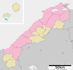
Izumo is a city in Shimane Prefecture, Japan. As of 31 July 2023, the city had an estimated population of 172,841 in 69,435 households and a population density of 280 persons per km2. The total area of the city is 624.36 square kilometers (241.07 sq mi).

<span class="mw-page-title-main">Oki Province</span> Former province of Japan

Oki Province was a province of Japan consisted of the Oki Islands in the Sea of Japan, located off the coast of the provinces of Izumo and Hōki. The area is now Oki District in modern Shimane Prefecture. Its abbreviated form name was Onshū or Inshū (隠州),

<span class="mw-page-title-main">Ureshino, Saga</span> City in Kyushu, Japan

Ureshino is a city located in the western part of Saga Prefecture on the island of Kyushu, Japan. As of 31 May 2024, the city had an estimated population of 24,529 in 10075 households, and a population density of 190 persons per km2. The total area of the city is 126.41 km2 (48.81 sq mi).

Saigō was a town located on the island of Dōgo in Oki District, Shimane Prefecture, Japan.

<span class="mw-page-title-main">Ama, Shimane</span> Town in Japan

Ama is a town located on Nakanoshima, in Oki District, Shimane Prefecture, Japan.

<span class="mw-page-title-main">Nishinoshima, Shimane</span> Town in Japan

Nishinoshima is a town located on the island of Nishinoshima, in Oki District, Shimane Prefecture, Japan. As of 1 October 2020, the town had an estimated population of 2,788 and a population density of 50 persons per km2. The total area was 55.98 km2 (22 sq mi).

<span class="mw-page-title-main">Oki District, Shimane</span>

Oki is a district located in Shimane Prefecture, Japan.

<span class="mw-page-title-main">Oki Islands</span> Archipelago in the Sea of Japan

The Oki Islands is an archipelago in the Sea of Japan, the islands of which are administratively part of Oki District, Shimane Prefecture, Japan. The islands have a total area of 346.1 square kilometres (133.6 sq mi). Only four of the around 180 islands are permanently inhabited. Much of the archipelago is within the borders of Daisen-Oki National Park. Due to their geological heritage, the Oki Islands were designated a UNESCO Global Geopark in September 2013.

<span class="mw-page-title-main">Okushiri, Hokkaido</span> Town in Hokkaido, Japan

Okushiri is a town on Okushiri Island, located in Hiyama Subprefecture, Hokkaido, Japan.

<span class="mw-page-title-main">Okinoshima, Shimane</span> Town in Japan

Okinoshima is a town located on Dōgo, in Oki District, Shimane Prefecture, Japan. As of June 2013, the town had an estimated population of 14,849 and a population density of 61.1 persons per km2. The total area was 242.95 km2.

<span class="mw-page-title-main">Unzen, Nagasaki</span> City in Kyushu, Japan

Unzen is a city located in Nagasaki Prefecture, Japan. As of 30 June 2024, the city had an estimated population of 40,831 in 17709 households, and a population density of 190 people per km2. The total area of the town is 214.31 km2 (82.75 sq mi).

<span class="mw-page-title-main">Nagaoka, Niigata</span> Special city in Chūbu, Japan

Nagaoka is a city located in Niigata Prefecture, Japan. It is the second largest city in the prefecture, after the capital city of Niigata. As of 4 August 2021, the city had an estimated population of 264,611 in 109,283 households and a population density of 300 inhabitants per square kilometre (780/sq mi). The total area of the city was 891.06 square kilometres (344.04 sq mi).

<span class="mw-page-title-main">Matsue</span> Core city in Chūgoku, Japan

Matsue is the capital city of Shimane Prefecture, Japan, located in the Chūgoku region of Honshu. As of 31 March 2023, the city had an estimated population of 196,748 in 91287 households and a population density of 340 persons per km². The total area of the city is 572.99 square kilometres (221.23 sq mi). Matsue is home to the Tokugawa-era Matsue Castle, one of the last surviving feudal castles in Japan.

<span class="mw-page-title-main">Unnan</span> City in Chūgoku, Japan

Unnan is a city located in Shimane Prefecture, Japan. As of 31 July 2023, the city had an estimated population of 35,279 in 13575 households and a population density of 64 persons per km2. The total area of the city is 553.18 square kilometres (213.58 sq mi).

<span class="mw-page-title-main">Iinan, Shimane</span> Town in Japan

Iinan is a town located in Iishi District, Shimane Prefecture, Japan. As of 1 August 2023, the town had an estimated population of 4,502 in 2018 households and a population density of 19 persons per km2. The total area of the town is 242.88 square kilometres (93.78 sq mi).

<span class="mw-page-title-main">Okinoumi Ayumi</span> Japanese sumo wrestler

Okinoumi Ayumi is a former Japanese professional sumo wrestler from Okinoshima, Shimane. He joined professional sumo in 2005, reaching the top division in 2010. He was runner-up in makuuchi three times in the January 2011, March 2013, and November 2017 tournaments, all with an 11–4 record. His highest rank was sekiwake, which he held for one tournament in March 2015 and then held again in November 2016. He has won four Fighting Spirit prizes, one prize for Outstanding Performance, and four gold stars for defeating yokozuna. He wrestled for Hakkaku stable. Upon his retirement, Okinoumi became a sumo coach under the name of Kimigahama.

<span class="mw-page-title-main">Chiburijima</span>

Chiburijima (知夫里島) is one of the Dōzen Islands in the Oki archipelago in the Sea of Japan.

References

  1. 1 2 "Past census data in chronological order" (in Japanese). 総務省統計局 (Ministry of Internal Affairs and Communications-Statistics Department). Retrieved November 27, 2009.
  2. 1 2 "Result Summary for Heisei 22 National Census" (in Japanese). 総務省統計局 (Ministry of Internal Affairs and Communications-Statistics Department). Archived from the original on March 24, 2011. Retrieved April 4, 2011.
  3. 1 2 月報:しまね統計情報データベース (in Japanese). 統計調査課. Retrieved April 5, 2011.
  4. 隠岐の島町ふるさと教育副教材集委員会, ed. (March 2007). ふるさと隠岐 (in Japanese).
  5. "過去の気象データ検索ー海士町 (Past Weather Data - Town of Ama)" (in Japanese). 気象庁(Japan Meteorological Agency). Retrieved October 21, 2009.
  6. "過去の気象データ検索ー隠岐の島町 (Past Weather Data - Town of Okinoshima)" (in Japanese). 気象庁(Japan Meteorological Agency). Retrieved October 23, 2009.