The Karachi Port Trust (KPT) (Urdu: ادارہِ تولیتِ بندرگاہ کراچی) is a Pakistani federal government agency, under the administrative control of the Federal Maritime Secretary that oversees the operations of the Port of Karachi, one of South Asia's largest and busiest deep-water seaports which handles over 90% of the nation's foreign trade. The agency is headquartered at the colonial-era Karachi Port Trust Building.

Keamari is a neighbourhood in Karachi, Sindh, Pakistan. Keamari was originally an independent settlement built on a sandy ridge on the eastern side of Karachi Harbour.
Machar Colony or Machiara Colony/Mohammadi Colony is an unplanned settlement in Karachi, Pakistan, located near the Port of Karachi and Harbour Kemari. The settlement is spread over an area of almost 4 square kilometers, and is home to about 700,000 people. It is considered to be one of the most dilapidated slums in Karachi. Many people are undocumented because there are not gave citizenship by the government of Pakistan, therefore many people are jobless.
SherShah is a neighbourhood in Karachi, Pakistan, that is located along the northern bank of the Lyari River. Sher Shah is home to the Morroro Graveyard - a vast cemetery that is centuries old. It is also the site of some of Karachi's recycling industry. In October 2010, Baloch terrorists gunned down 13 members of the Urdu-speaking community in a spare-parts market.

Paposh Nagar or Paposhnagar is a neighborhood in the Karachi Central district of Karachi, Pakistan.

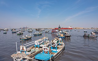
The Port of Karachi is one of South Asia's largest and busiest deep-water seaports, handling about 60% of the nation's cargo located in Karachi, Pakistan. It is located on the Karachi Harbour, between Kiamari Azra Langri, Manora, and Kakapir, and close to Karachi's main business district and several industrial areas. The geographic position of the port places it in close proximity to major shipping routes such as the Strait of Hormuz. It is also ideally located to offer gateway services to the maritime trade for the Central Asian Republics (CARs). The administration of the port is carried out by the Karachi Port Trust, which was established in 1857.
Baba and Bhit Islands are two small and densely populated islands located in the Karachi Harbour, in Karachi, Pakistan. The approximate area of Bhit island is roughly 0.16 km2 while that of Baba island is around 0.15 km2. Around 5,400 people live on Bhit island and around 6,600 on Baba island. With a population density of 33,750 and 44,000 people per km2 respectively, the two islands are among the most densely populated islands in the world.

The M-10 motorway or the Karachi Northern Bypass is a two-lane 57 km motorway in Manghopir Town, Karachi, Sindh, Pakistan. It connects the M-9 motorway to the Karachi Port, and provides an easy access to the transporters and to the commuters who can go directly to the Karachi port without entering the main arteries of city.
The city of Karachi is a major transport hub of Pakistan. The Karachi port and airport are major gateways to Pakistan. The Karachi Railway stations transports the major part of Pakistan's trade with other countries.
Sango Lane is one of the neighbourhoods of Lyari Town in Karachi, Sindh, Pakistan.
Shamspir is an island village near Karachi, Pakistan, along the western end of Karachi Harbour, close to Sandspit Beach and Kakapir. It is administered as part of the Keamari District. Approximately 5,000 people now live on the island. The village is bordered by thick Mangrove forests which grow in the harbour.
Kakapir, is a fishing village and former island in Karachi Harbour, 15 km (9.3 mi) to the west of central Karachi, Pakistan. It is located near Hawke's Bay Beach, at the western end of Sandspit Beach, which now connects the island to the mainland. Mauripur lies to its north. Kakapir is named for a saint, whose shrine is located in the village, who reportedly was known for his brown hair. "Kaka" is the Sindhi word for blond, while "Pir" means saint. The village is reportedly about 100 years old. Residents of the village were originally from the Mithadar and Kharadar neighborhoods of Karachi, who were settled by the British in Shams Pir during the construction of the Port of Karachi. Those residents migrated further west and established Kakapir.
Manora is a small peninsula that forms a protective barrier between Karachi Harbour to the north and the Arabian Sea to the south. Manora, having a total population of 4,273 local residents, was formerly an island, but due to silting is now connected to the mainland by a 12 kilometer long natural sand bridge known as Sandspit. The entrance to Karachi was once guarded against pirate raids by the Manora Fort built in the 1790s, which was later upgraded by the British, and then the Pakistan Navy.
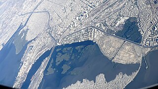
Karachi Harbour is a narrow bay and river estuary located west of the Indus River Delta in Karachi, Pakistan. The harbour lies between the Lyari River delta and Chinna Creek to the north, and the Arabian Sea to the south. Since 1886, sections of the harbour have been improved to form the Port of Karachi - Pakistan's busiest seaport.
KPT Officers Society is a disputed area in Karachi, Pakistan. The Karachi Port Trust (KPT), through its entity, the Karachi Port Trust Cooperative Housing Society, had planned this area as a neighbourhood.

The Pakistan Sailing Federation is the national governing body of the sport of sailing in Pakistan. Affiliated with World Sailing and the Asian Sailing Federation, it has its headquarters at the National Sailing Centre in Clifton, Karachi.

The Maritime Secretary of Pakistan, also referred to as Ports and Shipping Secretary, is the Federal Secretary for the Ministry of Maritime Affairs. The position holder is a BPS-22 grade officer, usually belonging to the Pakistan Administrative Service. The Maritime Secretary is considered to be a coveted slot in the Government of Pakistan, with major organisations such as the Pakistan National Shipping Corporation (PNSC), Karachi Port Trust (KPT), Port Qasim Authority (PQA) and Gwadar Port Authority (GPA) as well as the country's deep sea fishing between the territorial waters base line and the outermost limits of the exclusive economic zone falling under the Secretary's purview.
Chinna Creek is a lagoon, within the municipal boundaries of Karachi, on the coastline of the Arabian Sea, located in the south-west region of Sindh, Pakistan.
