You can help expand this article with text translated from the corresponding article in Basque. (October 2013)Click [show] for important translation instructions.
|
You can help expand this article with text translated from the corresponding article in Spanish. (October 2013)Click [show] for important translation instructions.
|
Elantxobe | |
|---|---|
 | |
 Coat of arms | |
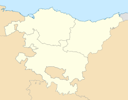 Elantxobe Location of Elantxobe within the Basque Country | |
| Coordinates: 43°24′14″N2°38′09″W / 43.40389°N 2.63583°W | |
| Country | Spain |
| Autonomous community | Basque Country |
| Province | Biscay |
| Comarca | Busturialdea |
| Founded | 1858 |
| Government | |
| • Mayor | Koldo Miren Olagibel Bakeriz (Bildu) |
| Area | |
• Total | 1.85 km2 (0.71 sq mi) |
| Elevation | 80 m (260 ft) |
| Population (2018) [1] | |
• Total | 346 |
| • Density | 190/km2 (480/sq mi) |
| Demonym | Basque: elantxobetar |
| Time zone | UTC+1 (CET) |
| • Summer (DST) | UTC+2 (CEST) |
| Postal code | 48310 |
| Official language(s) | Basque Spanish |
| Website | Official website |
Elantxobe is a town and municipality located in the province of Biscay, in the autonomous community of Basque Country, northern Spain.


