Staithes

Last updated

Staithes
Staithes (geograph 6937892).jpg
View of the village
North Yorkshire UK location map (2023).svg
Red pog.svg
Staithes
Location within North Yorkshire
OS grid reference NZ779185
Civil parish
Unitary authority
Ceremonial county
Region
Country England
Sovereign state United Kingdom
Post town SALTBURN-BY-THE-SEA
Postcode district TS13
Police North Yorkshire
Fire North Yorkshire
Ambulance Yorkshire
UK Parliament
List of places
UK
England
Yorkshire
54°33′23″N0°47′44″W / 54.5564°N 0.79561°W / 54.5564; -0.79561

Staithes is a village in North Yorkshire, England. Easington and Roxby Becks, which run into Staithes Beck, form the border between the unitary authorities of North Yorkshire and Redcar and Cleveland. [1] The area located on the Redcar and Cleveland side is called Cowbar. Formerly a hub for fishing and mining, Staithes is now a tourist destination in the North York Moors National Park.

Contents

History

The name Staithes derives from Old English and means 'landing-place'. [2] It has been suggested that it is so named after being the port for the nearby Seaton Hall and Hinderwell. [3] The spelling Steeas is sometimes used to indicate the traditional local dialect pronunciation /stɪəz/. [4]

At the turn of the 20th century, there were 80 full-time fishing boats putting out from Staithes. A hundred years later there are still a few part-time fisher men. There is a long tradition of using the coble (a traditional fishing vessel) in Staithes. [5] [6]

Staithes Staithes 2018.jpg
Staithes

Staithes has numerous narrow streets and passageways; one of these, Dog Loup, with a width of just 18 inches (45.7 cm), is claimed to be the narrowest alley in the world. [7] It was reported in 1997 that the Royal Mail were encouraging the occupants of Staithes to number their houses instead of relying on names. Whilst the usual postperson had no difficulty with the narrow streets and cottages, the relief postal staff were getting confused. Royal Mail also claimed it would aid the efficiency of their postal machines which automatically read the addresses. [8]

Geography

The oldest and best-known part of the village is clustered around the sheltered harbour, bounded by high cliffs and two long breakwaters. [9] The more modern upper village is located at the top of the hill, centred on the junction of the High Street and the A174 road. [10]

A mile to the west is Boulby Cliff where, for a brief period, alum was extracted from quarried shale and used as a mordant to improve the strength and permanency of colour when dying cloth. The mining operation ended when a cheaper chemical method was developed. [11] The ruined remnants of the mines can be seen from the cliff top when walking the Cleveland Way between Staithes and Skinningrove. [12]

Geology

Staithes is a destination for geologists researching the Jurassic (Lias), strata in the cliffs surrounding the village. In the early 1990s, a rare fossil of a seagoing dinosaur was discovered after a rockfall between Staithes and Port Mulgrave to the south. [13] This fossil has been the focus of an ongoing project to remove the ancient bones of the creature. Port Mulgrave remains one of the best places on the northern coast to find fossils of ammonites and many visitors spend hours cracking open the shaly rocks on the shoreline in the hope of finding a perfect specimen. [14]

Churches

The parish church is St Peter, Staithes. The Roman Catholic church of Our Lady, Star of the Sea was built in 1885.

Transport

Between 1883 and 1958, the village was served by Staithes railway station which was on the Whitby, Redcar and Middlesbrough Union Railway. [15] The southern end of the village is bisected by the A174 road between Thornaby-on-Tees and Whitby. [16]

Culture and events

The permanent population of Staithes has decreased since the 1970s, due to the decline of the fishing and mining industries and an increase in second homes and holiday cottages. Because of this, many of the village's traditions are no longer practiced.

Staithes Bonnets were traditionally worn by the women inhabitants of the village, with some older residents still wearing them daily in the 1990s. The cotton bonnets were sewn by hand, and helped to protect the wearer's hair and face when carrying out fishing work. The bonnets were traditionally white, but colourful and patterned bonnets came in during ths Second World War when fabric was being rationed, and the women would recycle their dresses into headgear. A black bonnet was worn during the deep mourning period, which was then swapped, after a period of 2-3 years, for a mauve or lavendar bonnet during half-mourning. There are a few women left in the village who still sew Staithes Bonnets. [17]

Men of Staithes are a fishermen's choir who perform sea shanties and hymns in the village.

The Roxby Run is a local pub crawl. It starts at The Fox and Hounds in the nearby village of Dalehouse then goes to Staithes Athletic Club, The Captain Cook Inn, The Black Lion (now closed) The Royal George before finishing at The Cod and Lobster on the harbour front. [18]

Staithes Museum is located in the disused primitive methodist chapel on Staithes High Street. The museum was set up by Reginald Firth in 1993 and houses a collection relating to the history of Staithes and Captain James Cook who lived in the village as a teenager. In 2019 the Museum was taken on by a charitable trust.

Staithes and Runswick RNLI Lifeboat Weekend takes place in August each year and features a nightgown parade. The event raises money for, and encourages participation with the Staithes and Runswick Lifeboat Station. [19]

Staithes Festival of Arts and Heritage takes place in September each year. The first event was held in 2012. [13] Houses and other properties throughout the village open their doors to the public as pop-up galleries, creating a trail through the village. In addition, events celebrating the heritage of Staithes are held. [20]

Several episodes of The Fast Show feature sketches filmed in Staithes.

The series Old Jack's Boat , starring Bernard Cribbins, was set and filmed in Staithes, [21] with Old Jack's house located at 4 Cowbar Bank. [22]

The film Phantom Thread features scenes filmed in Staithes. [23]

The 2020 Christmas special of Mortimer & Whitehouse: Gone Fishing saw Bob Mortimer and Paul Whitehouse was filmed in Staithes. A local tour guide noted that the village's appearance on the show had caused interest in the village to go "ballistic". [24]

Media

Local news and television programmes are provided by BBC North East and Cumbria and ITV Tyne Tees. Television signals are received from the Bilsdale TV transmitter and the local relay transmitter. [25]

Local radio stations are BBC Radio Tees, Capital North East, Smooth North East, Heart North East, Greatest Hits Radio Yorkshire Coast, This is The Coast and Coast and County Radio.

Staithes is covered by these local newspapers, Whitby Gazette and TeessideLive .

Sport

Staithes Athletic Club Cricket Club ground is situated off Seaton Crescent, Staithes. [26] The club has two senior teams: a Saturday 1st XI that compete in the Scarborough Beckett Cricket League, [27] a Midweek Senior XI in the Esk Valley Evening League [28] and a junior section that compete in the Derwent Valley Junior Cricket League. [29]

Notable people

James Cook worked in Staithes as a shop keeper's apprentice between 1745 and 1746. [30] He was apprenticed to local merchant and banker William Sanderson. Sanderson's shop, where Cook lived and worked, was destroyed by the sea c.1850, [16] but parts were recovered and incorporated into Captain Cook's Cottage on Church Street. [31]

Artists

The village was home to a group of around 50 artists known as the Staithes Group, or Northern Impressionists. The group was made up of painters such as Edward E. Anderson, Joseph R. Bagshawe, Thomas Barrett and James W. Booth; with Dame Laura Knight and her husband Harold Knight working in the village for many years. [32] The group mainly painted en plein air in oils and water colours and were inspired by the French impressionists. [33]

See also

Related Research Articles

<span class="mw-page-title-main">Whitby</span> Coastal town in North Yorkshire, England

Whitby is a seaside town, port and civil parish in North Yorkshire, England. It is on the Yorkshire Coast at the mouth of the River Esk. It has a maritime, mineral and tourist economy. The fishing port emerged during the Middle Ages, supporting important herring and whaling fleets, and was where Captain Cook learned seamanship and, coincidentally, where his first vessel to explore the southern ocean, HMS Endeavour, was built. Jet and alum were mined locally, and Whitby jet, which was mined by the Romans and Victorians, became fashionable during the 19th century.

<span class="mw-page-title-main">Redcar</span> Town in North Yorkshire, England

Redcar is a seaside town on the Yorkshire Coast in the Redcar and Cleveland unitary authority in the ceremonial county of North Yorkshire, England. It is located 7 miles (11 km) east of Middlesbrough.

<span class="mw-page-title-main">River Esk, North Yorkshire</span> River in North Yorkshire, England

The River Esk is a river in North Yorkshire, England that empties into the North Sea at Whitby after a course of around 28 miles (45 km) through the valley of Eskdale, named after the river itself. The river's name is derived from the Brythonic word "isca" meaning "water". The Esk is the only major river in Yorkshire that flows directly into the North Sea; all other watercourses defined as being major rivers by the Environment Agency, either flow to the North Sea via the River Tees or the Humber Estuary.

<span class="mw-page-title-main">Saltburn-by-the-Sea</span> Town in North Yorkshire, England

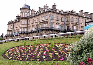
Saltburn-by-the-Sea, commonly referred to as Saltburn, is a seaside town in North Yorkshire, England, 12 miles (19 km) south-east of Hartlepool and 5 miles (8 km) south-east of Redcar. It lies within the historic boundaries of the North Riding of Yorkshire. It had a population of 5,958 in 2011.

<span class="mw-page-title-main">Loftus, North Yorkshire</span> Town and civil parish in North Yorkshire, England

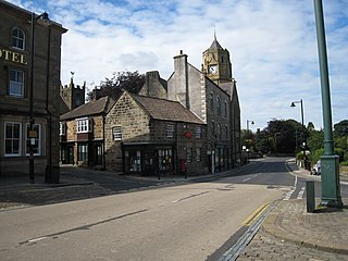
Loftus is a market town and civil parish in the Redcar and Cleveland borough of North Yorkshire, England. The town is located north of the North York Moors and sits between Whitby and Skelton-in-Cleveland.

<span class="mw-page-title-main">Esk Valley line</span> Railway line between Middlesbrough and Whitby, England

The Esk Valley Line is a railway line located in the north of England, covering a total distance of approximately 35 miles (56 km), running from Middlesbrough to Whitby. The line follows the course of the River Esk for much of its eastern half.

<span class="mw-page-title-main">Boulby</span> Village in North Yorkshire, England

Boulby is a hamlet in the Loftus parish, located within the North York Moors National Park. It is in the borough of Redcar and Cleveland, North Yorkshire, England. The hamlet is located off the A174, near Easington and 1-mile (1.6 km) west of Staithes.

<span class="mw-page-title-main">Easington, North Yorkshire</span> Village in North Yorkshire, England

Easington is a village in the civil parish of Loftus, in the Redcar and Cleveland district, in the ceremonial county of North Yorkshire, England and is part of the North York Moors National Park. The village is situated on the A174 road, 1 mile (1.6 km) east of Loftus, 8 miles (13 km) east of Guisborough, and 10 miles (16 km) north-west of Whitby. At the 2011 census, the village had a population of 923.

<span class="mw-page-title-main">Cleveland Hills</span>

The Cleveland Hills are a range of hills on the north-west edge of the North York Moors in North Yorkshire, England, overlooking Cleveland and Teesside. They lie entirely within the boundaries of the North York Moors National Park. Part of the 110-mile (177 km) long Cleveland Way National Trail runs along the hills, and they are also crossed by a section of Wainwright's Coast to Coast Walk. The hills, which rise abruptly from the flat Tees Valley to the north, include distinctive landmarks such as the cone-shaped peak of Roseberry Topping, near the village of Great Ayton – childhood home of Captain James Cook.

<span class="mw-page-title-main">Whitby, Redcar and Middlesbrough Union Railway</span> Former railway line in Yorkshire, England

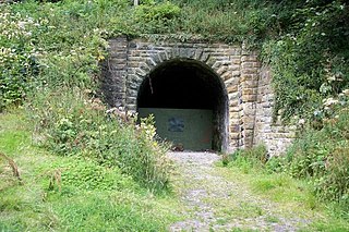
The Whitby, Redcar and Middlesbrough Union Railway (WRMU), a.k.a. the Whitby–Loftus Line, was a railway line in North Yorkshire, England, built between 1871 and 1886, running from Loftus on the Yorkshire coast to the Esk at Whitby, and connecting Middlesbrough to Whitby along the coast.
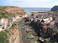
<span class="mw-page-title-main">Hinderwell</span> Village and civil parish in North Yorkshire, England

Hinderwell is a village and civil parish in North Yorkshire, England which lies within the North York Moors National Park, about a mile from the coast on the A174 road between the towns of Loftus and Whitby. The 2011 UK census states Hinderwell parish had a population of 1,875, a decrease on the 2001 UK census figure of 2,013. Hinderwell was the most northerly parish in the Scarborough Borough Council area until its abolition in 2023. Hinderwell is mentioned in the Domesday Book of 1086 as Hildrewell, and is said to have got its name from Saint Hilda of Whitby, the Abbess of Whitby Abbey.

<span class="mw-page-title-main">Runswick Bay</span> Village in North Yorkshire, England

Runswick Bay is a bay in North Yorkshire, England. It is also the name of a village located on the western edge of the bay. It is 5 miles (8 km) north of Whitby, and close to the villages of Ellerby and Hinderwell. It is a popular tourist attraction due to its picturesque cliffside village, stunning coastal walks, fossil hunting and Runswick Sands, a white sand beach. It is on the Cleveland Way national trail. Runswick Bay was chosen as Beach of the Year 2020 by The Sunday Times.

<span class="mw-page-title-main">Yorkshire Coast</span> Coastline of Yorkshire, England

The Yorkshire Coast runs from the Tees estuary to the Humber estuary, on the east coast of England. The cliffs at Boulby are the highest on the east coast of England, rising to 660 feet (200 m) above the sea level.

<span class="mw-page-title-main">Staithes and Runswick Lifeboat Station</span> Lifeboat station in North Yorkshire, England

Staithes and Runswick Lifeboat Station is a Royal National Lifeboat Institution (RNLI) lifeboat station based in the village of Staithes, North Yorkshire, England. The station was first opened in 1875 but has been closed for two periods between then and the 21st century due to a decline in the fishing industry and the ability to supply people to crew the lifeboat. It is now host to an Inshore Lifeboat (ILB).

<span class="mw-page-title-main">Runswick Bay Lifeboat Station</span> Lifeboat station in North Yorkshire, England

Runswick Bay Lifeboat Station was a Royal National Lifeboat Institution (RNLI) lifeboat station located in Runswick Bay in North Yorkshire, England. The station was opened in 1866, with a sister station opening at Staithes nine years later. Staithes Lifeboat Station was closed in 1922, and barring another short period of operation at Staithes, Runswick Bay was a mainstay of lifeboat operations on the Yorkshire coast until 1978, when Runswick Bay was closed and Staithes was re-activated.

<span class="mw-page-title-main">Scaling Dam Reservoir</span> Reservoir in North Yorkshire, England

Scaling Dam Reservoir is a freshwater man-made lake on the edge of the A171 road in North Yorkshire, England. The reservoir is near to the hamlet of Scaling Dam from where it derives its name, and was built in 1958.

<span class="mw-page-title-main">Port Mulgrave, North Yorkshire</span> Former port in North Yorkshire, England

Port Mulgrave is a derelict former ironstone exporting port on the North Yorkshire coast midway between Staithes and Runswick Bay in the civil parish of Hinderwell. Rows of domestic properties and individual houses exist on the top of the cliff.

<span class="mw-page-title-main">Yorkshire coast fishery</span> History of sea fishing in Yorkshire, England

The Yorkshire coast fishery has long been part of the Yorkshire economy for centuries. The 114-mile (183 km) Yorkshire Coast, from the River Tees to the Humber estuary, has many ports both small and large where the fishing trade thrives. The historic ports at Hull and Whitby are important locations for the landing and processing of fish and shellfish. Scarborough and Bridlington are also sites of commercial fishing.

<span class="mw-page-title-main">Kettleness</span> Hamlet in North Yorkshire, England

Kettleness, is a hamlet in the Scarborough District of North Yorkshire, England. The settlement only consists of half-a-dozen houses, but up until the early 19th century, it was a much larger village. However, most of that village, which was on the headland, slipped into the sea as a result of instability caused by quarrying for the alum industry. Kettleness became a smaller settlement, with houses rebuilt slightly further inland.

<span class="mw-page-title-main">Grinkle Mine</span> Former ironstone mine in North Yorkshire, England

Grinkle Mine, was an ironstone mine working the main Cleveland Seam near to Roxby in North Yorkshire, England. Initially, the ironstone was mined specifically for the furnaces at the Palmer Shipbuilders in Jarrow on the River Tyne, but later, the mine became independent of Palmers. To enable the output from the mine to be exported, a 3-mile (4.8 km) narrow-gauge tramway was constructed that ran across three viaducts and through two tunnels to the harbour of Port Mulgrave, where ships would take the ore directly to Tyneside.

References

  1. "OL27" (Map). North York Moors. 1:25,000. Explorer. Ordnance Survey. 2016. ISBN   9780319242667.
  2. Ekwall, Eilert (1960). The Concise Oxford Dictionary of English Place-names (4th ed.). Oxford: Clarendon Press. p. 436. ISBN   0-19-869103-3.
  3. "Staithes conservation area appraisal" (PDF). northyorkmoors.org.uk. North York Moors National Park Authority. January 2001. p. 3. Retrieved 3 April 2017.
  4. Kellett, Arnold (1994), The Yorkshire Dictionary of Dialect, Tradition and Folklore, Smith Settle, p. 175, ISBN   1-85825-016-1
  5. "Ports.org.uk / Staithes". www.ports.org.uk. Retrieved 31 March 2017.
  6. "From Captain Cook to CBeebies at the seaside". Yorkshire Evening Post. 6 March 2017. Retrieved 3 April 2017.
  7. "A Travel guide to the seaside town of Staithes, Yorkshire". Travel Earth. 23 May 2010. Retrieved 2 July 2021.
  8. Burnham, Nigel (24 March 1997). "Number's up for Captain Cook's village" . The Independent. Archived from the original on 24 May 2022. Retrieved 3 April 2017.
  9. "Better moorings for Staithes harbour". Whitby Gazette. 16 August 2016. Retrieved 2 April 2017.
  10. "Images of the Old Fishing Village". www.staithes-town.info. Retrieved 23 March 2024.
  11. Historic England. "Boulby Alum Quarries and works (1018336)". National Heritage List for England . Retrieved 2 April 2017.
  12. Dillon, Paddy (2010). The Cleveland Way and the Yorkshire Wolds Way with the Tabular Hills walk. Cumbria: Cicerone Press. pp. 144–147. ISBN   978-1849654128.
  13. 1 2 "Picture Post: Wave of visitors for Staithes, courtesy of children's TV show". The Yorkshire Post. 3 February 2014. Retrieved 31 March 2017.
  14. Appleby, John (11 August 2014). "Hanging by a thread: Whitby's jet and fossil hunters". The Guardian.
  15. "Disused Stations: Staithes Station". www.disused-stations.org.uk. Retrieved 3 April 2017.
  16. 1 2 England (6 ed.). London: Rough Guides. 2004. p.  1031. ISBN   1-84353-249-2.
  17. Jeffels, David (30 June 2010). "Keeping the fishing bonnets tradition alive in Staithes". Gazette & Herald. Retrieved 2 April 2017.
  18. "Staithes - The North Yorkshire Gallery". The North Yorkshire Gallery. Retrieved 3 April 2017.
  19. Robson, Dave (9 August 2018). "Staithes Lifeboat Weekend to go ahead despite rock fall tragedy". Gazette Live. Retrieved 9 March 2019.
  20. "Staithes Festival". Staithes Festival of Art and Heritage. Retrieved 31 March 2017.
  21. "Staithes showcased in children's TV programme Old Jack's Boat". Whitby Gazette. 23 January 2013. Retrieved 31 March 2017.
  22. "Staithes". www.yorkshireguides.com. Retrieved 31 March 2017.
  23. "TV and Film Locations". North York Moors National Park . Retrieved 2 February 2018.
  24. Storer, Rhi (20 December 2020). "'Gone ballistic': village of Staithes basks in BBC fishing limelight". The Guardian. ISSN   0261-3077 . Retrieved 26 December 2023.
  25. "Freeview Light on the Staithes (Redcar and Cleveland, England) transmitter". UK Free TV. 1 May 2004. Retrieved 24 January 2024.
  26. "Staithes Athletic Club CC website". staithesathletic.play-cricket.com. Staithes Athletic Club Cricket Club. Retrieved 17 October 2021.
  27. "Scarborough Beckett Cricket League". scarboroughbeckettlge.play-cricket.com. SBCL. Retrieved 17 October 2021.
  28. "Esk Valley Evening League". eskvalleyeveninglge.play-cricket.com. EVEL. Retrieved 17 October 2021.
  29. "Derwent Valley Junior Cricket League". derwentvalleyjcl.play-cricket.com. DVJCL. Retrieved 17 October 2021.
  30. Beaglehole, J. C. (1992). "1: The North Sea". The life of Captain James Cook (9 ed.). California.: Stanford Univ. Press. p. 5. ISBN   0-8047-2009-6.
    - "Captain James Cook's early life at Staithes". www.staithes-town.info. Retrieved 3 April 2017.
  31. "James Cook in the North East - Staithes and Whitby". www.captcook-ne.co.uk. Retrieved 3 April 2017.
  32. "Forgotten work by Staithes Group artist goes under the hammer". Yorkshire Post. 14 February 2016. Retrieved 3 April 2017.
  33. "Eminent Staithes Group artwork hidden away for a century". Whitby Gazette. 11 September 2012. Retrieved 3 April 2017.
    - "Hidden talents". The Northern Echo. 15 February 2010. Retrieved 3 April 2017.