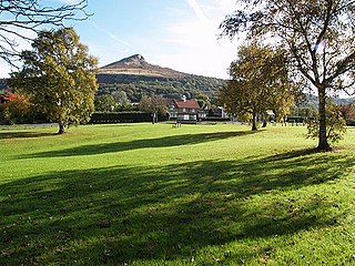
Guisborough is a market town and civil parish in the borough of Redcar and Cleveland, North Yorkshire, England. It lies north of the North York Moors National Park. Roseberry Topping, midway between the town and Great Ayton, is a landmark in the national park. It was governed by an urban district and rural district in the North Riding of Yorkshire.

The North Riding of Yorkshire was a subdivision of Yorkshire, England, alongside York, the East Riding and West Riding. The riding's highest point was at Mickle Fell at 2,585 ft (788 m).

Redcar and Cleveland is a unitary authority area with borough status in the ceremonial county of North Yorkshire, England. Its council has been a unitary authority since 1996.

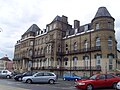
Redcar is a seaside town on the Yorkshire Coast in the Redcar and Cleveland unitary authority. It is in the ceremonial county of North Yorkshire, England, and is located 7 miles (11 km) east of Middlesbrough.

Tees Valley is a combined authority area in North East England, around the lower River Tees. The area is not a geographical valley; the local term for the valley is Teesdale. The combined authority covers five council areas: Darlington, Hartlepool, Middlesbrough, Redcar and Cleveland and Stockton-on-Tees.
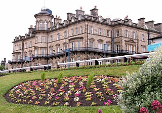
Saltburn-by-the-Sea, commonly referred to as Saltburn, is a seaside town in the civil parish of Saltburn, Marske and New Marske, in the Redcar and Cleveland district, in North Yorkshire, England, 12 miles (19 km) south-east of Hartlepool and 5 miles (8 km) south-east of Redcar. It lies within the historic boundaries of the North Riding of Yorkshire.

Marske-by-the-Sea is a village in the civil parish of Saltburn, Marske and New Marske, North Yorkshire, England, between the seaside resorts of Redcar and Saltburn-by-the-Sea.
Normanby is an area in the borough of Redcar and Cleveland, North Yorkshire, England. It is part of Greater Eston, which includes the area and the outlying settlements of Eston, Grangetown, South Bank, Teesville and part of Ormesby.

Ormesby is a village and area split between the unitary authority areas of Middlesbrough and Redcar and Cleveland in North Yorkshire, England.
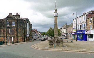
Brotton is a village in the civil parish of Skelton and Brotton, in the Redcar and Cleveland district, in the ceremonial county of North Yorkshire, England It is situated approximately 2.5 miles (4 km) south-east of Saltburn-by-the-Sea, 9 miles from Redcar, 12 miles (19 km) east of Middlesbrough and 14 miles (23 km) north-west of Whitby.

Langbaurgh was a liberty or wapentake of the North Riding of Yorkshire. It covered an area of the shire's north-eastern tip. The wapentake took its name from Langbaurgh hamlet, in present-day Great Ayton parish.

Easington is a village in the civil parish of Loftus, in the Redcar and Cleveland district, in the ceremonial county of North Yorkshire, England and is part of the North York Moors National Park. The village is situated on the A174 road, 1 mile (1.6 km) east of Loftus, 8 miles (13 km) east of Guisborough, and 10 miles (16 km) north-west of Whitby.

Kilton is a village in the civil parish of Lockwood, in the borough of Redcar and Cleveland, in the ceremonial county of North Yorkshire, England.
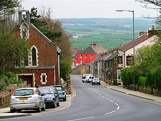
Newton under Roseberry is a village in the civil parish of Guisborough, in the borough of Redcar and Cleveland and the ceremonial county of North Yorkshire, England. It is on the A173, between Great Ayton and Guisborough and is close to the base of Roseberry Topping.

Kirkleatham is an area of Redcar in the borough of Redcar and Cleveland in North Yorkshire, England. It is approximately 4+1⁄2 miles north-northwest of Guisborough, and three miles south of Redcar centre. It was listed in the Domesday Book of 1086.

Upleatham is a village in the civil parish of Guisborough, in the unitary authority area of Redcar and Cleveland and the ceremonial county of North Yorkshire, England. The village was mentioned in the Domesday Book and the name derives from Old English and Old Norse as Upper Slope, in that it was further up the hill than Kirkleatham.

Pinchinthorpe is a small hamlet in the civil parish of Guisborough, in the Redcar and Cleveland district of North Yorkshire, England. It is a linear settlement spread along the A173. The postcode is TS14 8HE.

Redcar and Cleveland Borough Council is the local authority for Redcar and Cleveland, a local government district with borough status in the ceremonial county of North Yorkshire, England. Since 1996 the council has been a unitary authority, being a district council which also performs the functions of a county council. The council was created in 1974 as Langbaurgh Borough Council and was a lower-tier authority until 1996 when it was renamed and became a unitary authority, taking over county-level functions from the abolished Cleveland County Council.

Coatham Marsh is a 54-hectare (130-acre) nature reserve near to Redcar in the borough of Redcar and Cleveland, England. The site is a local nature reserve and part of the Teesmouth and Cleveland Coast SSSI.