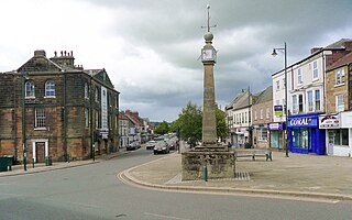
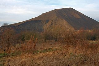
Lockwood, North Yorkshire

Last updated

Lockwood
Civil parish
Lockwood, North Yorkshire UK parish locator map.svg
Population3,708 (2011 census) [1]
OS grid reference NZ668156
Civil parish
  • Lockwood
Unitary authority
Ceremonial county
Region
Country England
Sovereign state United Kingdom
Post town SALTBURN-BY-THE-SEA
Postcode district TS12
Police Cleveland
Fire Cleveland
Ambulance North East
UK Parliament
List of places
UK
England
Yorkshire
54°32′20″N0°58′01″W / 54.539°N 0.967°W / 54.539; -0.967

Lockwood is a civil parish in the unitary authority of Redcar and Cleveland with ceremonial association with North Yorkshire, England. The population of Lockwood ward in the Redcar and Cleveland Unitary authority taken at the 2011 census was 2,022. [2]

Contents

The parish was historically in the North Riding of Yorkshire until 1974, when it was transferred to Cleveland. In 1996, it was given to the newer county of North Yorkshire. [3]

Description

The larger part of the parish (to the south) is rural with a small section of moorland in the North York Moors National Park. The parish covers over 3,950 hectares (9,800 acres) of land between Guisborough to the west, Skinningrove to the north, Staithes to the east and Commondale to the south. [4]

The A171 road runs diagonally north–south across the bottom corner of the parish and just south of Lockwood Beck is Lockwood Beck Reservoir. [5] The reservoir covers a surface area of 33 acres (13.2 hectares) and has a perimeter of 1 mile (1.5 km). It was built in 1872 and feeds water into Lockwood Beck, which flows into the North Sea at Skinningrove as Kilton Beck. [6] [7] The reservoir is noted for its fishery and wildlife, with nathusius’ pipistrelle bats and ospreys being recorded at the site. [8] [9]

The southern part of the parish is peppered with Neolithic Barrows and scheduled monuments, [10] [11] whereas the north part is more populated and has a history of ironstone mining. Both Kilton and Lingdale had mines that supplied iron to the forges and smelters on Teesside. [12] These were linked via industrial railways into the national network at Boosbeck. [13]

The hamlet of Kilton has the now grade I listed ruins of a 13th-century castle. [14] A timber constructed castle had existed on the site previously to the stone being built between 1190 and 1200. It was partially abandoned in the 14th century and by the 16th century, it was described as being worthless. [15]

Lockwood is the location of one of three ventilation shafts for the new tunnel carrying polyhalite from Woodsmith Mine to Wilton on Teesside. Roadworks to accommodate new traffic on the A171 road were completed in 2017 with groundworks on the shaft and tunnel being started in 2018. [16]

The parish includes the hamlets and villages of; [17]

Related Research Articles

<span class="mw-page-title-main">North Riding of Yorkshire</span> Third of a historic county in England

The North Riding of Yorkshire was a subdivision of Yorkshire, England, alongside York, the East Riding and West Riding. The riding's highest point was at Mickle Fell at 2,585 ft (788 m).

<span class="mw-page-title-main">Saltburn-by-the-Sea</span> Town in North Yorkshire, England

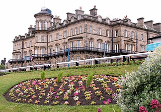
Saltburn-by-the-Sea, commonly referred to as Saltburn, is a seaside town in Redcar and Cleveland, North Yorkshire, England, around 12 miles (19 km) south-east of Hartlepool and just under 5 miles (8 km) south-east of Redcar.

<span class="mw-page-title-main">Loftus, North Yorkshire</span> Town and civil parish in North Yorkshire, England

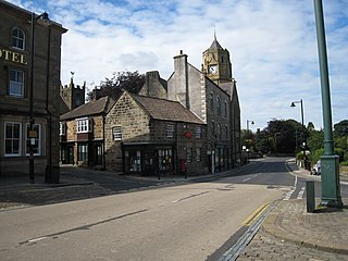
Loftus is a market town and civil parish in the Redcar and Cleveland borough of North Yorkshire, England. The town is located north of the North York Moors and sits between Whitby and Skelton-in-Cleveland.

<span class="mw-page-title-main">Dorman Long</span> British steel company

Dorman Long & Co was a UK steel producer, later diversifying into bridge building. The company was once listed on the London Stock Exchange.

<span class="mw-page-title-main">Skinningrove</span> Village in North Yorkshire, England

Skinningrove is a village in the civil parish of Loftus, in the Redcar and Cleveland district, in the ceremonial county of North Yorkshire, England. Its name is of Old Norse etymology and is thought to mean skinners' grove or pit.

<span class="mw-page-title-main">Kilton, North Yorkshire</span> Village in the Borough of Redcar and Cleveland, England

Kilton is a village in the civil parish of Lockwood, in the borough of Redcar and Cleveland, in the ceremonial county of North Yorkshire, England.

<span class="mw-page-title-main">Kilton Thorpe</span> Village in North Yorkshire, England

Kilton Thorpe is a village in the borough of Redcar and Cleveland and the ceremonial county of North Yorkshire, England. Noted for evidence of early settlement. The outlines of an ancient village are visible in fields adjacent to the present village.

<span class="mw-page-title-main">North Skelton</span> Village in Redcar and Cleveland, England

North Skelton is a village in Redcar and Cleveland, North Yorkshire, England.

The Cleveland Railway was a railway line in north-east England running from Normanby Jetty on the River Tees, near Middlesbrough, via Normanby and then via Guisborough through the Eston Hills, to Loftus in East Cleveland. It carried minerals from numerous iron ore mines along its route to the River Tees for shipment to Tyneside and elsewhere. The line was jointly proposed by the West Hartlepool Harbour and Railway (WHH&R), who provided half its capital, together with various landowners. The WHH&R lay on the north bank of the Tees, to which it had a cross-river connection via a jetty at Normanby.

<span class="mw-page-title-main">Woodsmith Mine</span> Polyhalite mine in North Yorkshire, England

Woodsmith Mine is a deep potash and polyhalite mine located near to the hamlet of Sneatonthorpe, Whitby in North Yorkshire, England. The venture was started by York Potash Ltd, which became a subsidiary of Sirius Minerals plc whose primary focus is the development of the polyhalite project. The project will mine the world's largest known deposit of polyhalite – a naturally occurring mineral. Because the project would require mining to be undertaken in the North York Moors National Park, many objections were raised to the mine and the proposed conveyor that would be installed to transport the raw material offsite to a plant on Teesside 23 miles (37 km) away.

<span class="mw-page-title-main">Hawsker</span> Villages in North Yorkshire, England

Hawsker is the name for the combined villages of High and Low Hawsker that straddle the A171 road 2.5 miles (4 km) southeast of Whitby, in North Yorkshire, England.

<span class="mw-page-title-main">Kilton Castle</span> Former castle in North Yorkshire, England

Kilton Castle is a ruined castle overlooking the valley of Kilton Beck, near to the village of Kilton in the historic county of the North Riding of Yorkshire in England. The castle was built in the 12th century and was described as being in a ruinous state by the 14th century, with it being totally abandoned by the 16th century. Kilton Castle was owned by several noble families who hailed from the area; de Brus, de Kilton, Autrey, de Thweng, de Lumley.

<span class="mw-page-title-main">Woodsmith Mine Tunnel</span> Tunnel in North Yorkshire, England

The Woodsmith Mine Tunnel is a 23-mile (37 km) long tunnel that will stretch between Woodsmith Mine at Sneatonthorpe near Whitby in North Yorkshire and the Wilton International complex on Teesside, England. The tunnel has been in development since 2016, but cutting of the tunnel bore did not start until April 2019, with a projected finish date of 2021, but it was still not complete by the end of 2023. By the end of July 2020, over 4 miles (6.4 km) of tunnel had been dug.

<span class="mw-page-title-main">Boosbeck railway station</span> Disused railway station in North Yorkshire, England

Boosbeck railway station was a railway station serving the village of Boosbeck in the ceremonial county of the North Riding of Yorkshire in England. The station was opened in 1878 and closed to passengers in 1960 with freight services being stopped in 1964.

<span class="mw-page-title-main">Scaling Dam Reservoir</span> Reservoir in North Yorkshire, England

Scaling Dam Reservoir is a freshwater man-made lake on the edge of the A171 road in North Yorkshire, England. The reservoir is near to the hamlet of Scaling Dam from where it derives its name, and was built in 1958.

<span class="mw-page-title-main">Kettleness</span> Hamlet in North Yorkshire, England

Kettleness, is a hamlet in the Scarborough District of North Yorkshire, England. The settlement only consists of half-a-dozen houses, but up until the early 19th century, it was a much larger village. However, most of that village, which was on the headland, slipped into the sea as a result of instability caused by quarrying for the alum industry. Kettleness became a smaller settlement, with houses rebuilt slightly further inland.

<span class="mw-page-title-main">Grinkle Mine</span> Former ironstone mine in North Yorkshire, England

Grinkle Mine, was an ironstone mine working the main Cleveland Seam near to Roxby in North Yorkshire, England. Initially, the ironstone was mined specifically for the furnaces at the Palmer Shipbuilders in Jarrow on the River Tyne, but later, the mine became independent of Palmers. To enable the output from the mine to be exported, a 3-mile (4.8 km) narrow-gauge tramway was constructed that ran across three viaducts and through two tunnels to the harbour of Port Mulgrave, where ships would take the ore directly to Tyneside.

<span class="mw-page-title-main">Ironstone mining in Cleveland and North Yorkshire</span> Ironstone mines and quarries in Cleveland and North Yorkshire, England

Ironstone mining in Cleveland and North Yorkshire occurred on a sizeable scale from the 1830s to the 1960s in present day eastern parts of North Yorkshire but has been recorded as far back as Roman times in mostly a small-scale and intended for local use. This Cleveland is not to be confused with a smaller area covered by the county of Cleveland from 1974-96.

<span class="mw-page-title-main">Kilton Viaduct</span> Viaduct in Yorkshire, England

Kilton Viaduct was a railway viaduct that straddled Kilton Beck, near to Loftus, in North Yorkshire, England. The viaduct was opened to traffic in 1867, however in 1911, with the viaduct suffering subsidence from the nearby ironstone mining, the whole structure was encased in waste material from the mines creating an embankment which re-opened fully to traffic in 1913. The railway closed in 1963, but then in 1974, it re-opened as part of the freight line to Boulby Mine carrying potash traffic.
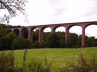
<span class="mw-page-title-main">Slapewath</span> Hamlet in Redcar and Cleveland, England

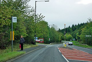
Slapewath is a hamlet in the borough of Redcar and Cleveland and the ceremonial county of North Yorkshire, England. Whilst the name of the hamlet is recorded as far back as the 13th century, it was developed due to the alum and ironstone industries of the North-Eastern part of Yorkshire in the 16th and 19th centuries respectively. The hamlet lies on the A171 road.

References

  1. UK Census (2011). "Local Area Report – Lockwood Parish (E04000264)". Nomis. Office for National Statistics . Retrieved 14 April 2019.
  2. UK Census (2011). "Local Area Report – Lockwood Ward (as of 2011) (E05001513)". Nomis. Office for National Statistics . Retrieved 14 April 2019.
  3. "East Cleveland Registration District". ukmbd.org.uk. Retrieved 14 April 2019.
  4. "ONS Geography Linked Data | Lockwood". statistics.data.gov.uk. Retrieved 14 April 2019.
  5. "OL27" (Map). North York Moors - Eastern area. 1:25,000. Explorer. Ordnance Survey. 2016. ISBN   9780319242667.
  6. "Recording our shared Industrial Heritage". www.industrialhistoryonline.co.uk. Retrieved 14 April 2019.
  7. "Lockwood Beck Reservoir overview". environment.data.gov.uk. Retrieved 14 April 2019.
  8. "Nathusius' Pipistrelle". nhsn.ncl.ac.uk. Retrieved 14 April 2019.
  9. "Cleveland Local Group - The Royal Society for the Protection of Birds". ww2.rspb.org.uk. Retrieved 14 April 2019.
  10. Historic England. "Round barrow on the summit of Brown Hill (1018769)". National Heritage List for England . Retrieved 14 April 2019.
  11. Historic England. "Two round barrows on Moorsholm Moor known as Black Howes (1015446)". National Heritage List for England . Retrieved 14 April 2019.
  12. Chapman, N A; Chapman, S A (1985). "Lumpsey Ironstone Mine". British Mining: Memoirs of the Northern Mine Research Society. Skipton: Northern Mine Research Society (28): 2. ISSN   0308-2199.
  13. Bairstow, Martin (2008). Railways around Whitby: Scarborough - Whitby - Saltburn, Malton - Goathland - Whitby, Esk Valley, Forge Valley and Gilling lines. Farsley: Martin Bairstow. p. 32. ISBN   9781871944341.
  14. Historic England. "Remains of Kilton Castle (Grade I) (1136489)". National Heritage List for England . Retrieved 14 April 2019.
  15. Historic England. "Kilton Castle: tower keep castle 130m east of Castle Cottages (1018946)". National Heritage List for England . Retrieved 14 April 2019.
  16. Cain, James (20 April 2017). "Roadworks to start near Teesside as part of £2bn mine plan". Gazette Live. Retrieved 14 April 2019.
  17. "Your Parish - Lockwood Parish Council". www.lockwoodpc.co.uk. Retrieved 14 April 2019.