
Rothwell is a town in the south-east of the City of Leeds metropolitan borough in West Yorkshire, England. It is situated between Leeds and Wakefield.

Redcar and Cleveland is a unitary authority area with borough status in the ceremonial county of North Yorkshire, England. Its council has been a unitary authority since 1996.

Woodlands is a model village 4 miles (6 km) north-west of Doncaster in South Yorkshire, England. The village lies adjacent to Highfields and Adwick le Street within the City of Doncaster. The colliery village was designed and built in the early 20th century by the architect Percy Houfton as tied cottages for the miners of the neighbouring Brodsworth Colliery. In an era of model villages such as Saltaire, Port Sunlight and Bournville, Woodlands, with extensive open spaces, many different designs of houses, and overall living conditions excellent for their time, possibly represents the height of the model village movement. The village is a conservation area.

Birdwell is a village in the Metropolitan Borough of Barnsley in South Yorkshire, England and is located approximately 4.5 miles (7 km) south of Barnsley, 12.1 miles (19 km) north-east of Sheffield. Birdwell falls within the Rockingham Ward of the Barnsley Metropolitan Council. Neighbouring areas include Worsbrough Village, Tankersley and Hoyland Common.

Grassington is a village and civil parish in North Yorkshire, England. The population of the parish at the 2011 Census was 1,126. Historically part of the West Riding of Yorkshire, and now in the lieutenancy area of North Yorkshire, the village is situated in Wharfedale, about 8 miles (10 km) north-west from Bolton Abbey, and is surrounded by limestone scenery. Nearby villages include Linton, Threshfield, Hebden, Conistone and Kilnsey.

Gipton is a suburb of east Leeds, West Yorkshire, England, between the A58 to the north and the A64 to the south.

Middleton is a largely residential suburb of Leeds in West Yorkshire, England and historically a village in the West Riding of Yorkshire. It is situated on a hill 4 miles (6 km) south of Leeds city centre and 165 miles (266 km) north north-west of London.

Ireland Wood is a small residential area in north-west Leeds, West Yorkshire, England named after the Woodland Trust wood which it contains. It is approximately 4 miles (6.4 km) to the north-west of Leeds city centre. It was planned by the Leeds Housing Director, R.A.H. Livett, and won the Ministry Housing medal for 1945-9. An early plan of Ireland Wood in 1950 is shown on the Leodis website.
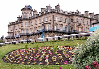
Saltburn-by-the-Sea, commonly referred to as Saltburn, is a seaside town in the civil parish of Saltburn, Marske and New Marske, in the Redcar and Cleveland district, in North Yorkshire, England, 12 miles (19 km) south-east of Hartlepool and 5 miles (8 km) south-east of Redcar. It lies within the historic boundaries of the North Riding of Yorkshire.

Oakenshaw is a village located in both the City of Bradford and Kirklees in West Yorkshire, England. It is located midway between the town of Cleckheaton in Kirklees and the suburb of Wyke in Bradford. The village is close to the M606 motorway. The village's main shopping centre is on Bradford Road and its main church, dedicated to St Andrew, is a grade II listed building.

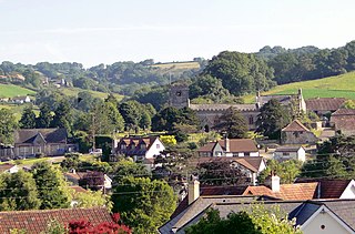
Marske-by-the-Sea is a village in the civil parish of Saltburn, Marske and New Marske, in the unitary authority area of Redcar and Cleveland and the ceremonial county of North Yorkshire, England. It is located on the coast, between the seaside resorts of Redcar and Saltburn-by-the-Sea, although it is not itself a seaside resort. Marske comprises the wards of Longbeck and St Germains.

Barton is a village and civil parish in the South Cambridgeshire district of Cambridgeshire, England. It is about 4 miles (6.4 km) south-west of Cambridge, near junction 12 of the M11 motorway.

Upleatham is a village in the civil parish of Guisborough, in the unitary authority area of Redcar and Cleveland and the ceremonial county of North Yorkshire, England. The village was mentioned in the Domesday Book and the name derives from Old English and Old Norse as Upper Slope, in that it was further up the hill than Kirkleatham.

Thorner is a rural village and civil parish in the City of Leeds in West Yorkshire, England, located between Seacroft and Wetherby. It had a population of 1,646 at the 2011 Census.

Edlington is a town and civil parish in the City of Doncaster, South Yorkshire, England, lying to the south west of Doncaster and Warmsworth. It has a population of 8,276. The original parish town of Edlington is now known as Old Edlington; adjacent, and to the north, is New Edlington. It is often referred to by locals as 'Edlo'. Since 1974 Edlington has been part of the Metropolitan Borough of Doncaster in the metropolitan county of South Yorkshire. It had, since 1894, formed part of Doncaster Rural District in the West Riding of Yorkshire.
Uplyme is an English village and civil parish in East Devon on the Devon-Dorset border and the River Lym, adjacent to the Dorset coastal town of Lyme Regis. It has a population of approximately 1700 recounted as 1663 at the 2011 census. Uplyme is situated in the electoral ward of Trinity whose population at the above census was 2,521.

Collingham is a village and civil parish 2 miles (3 km) south-west of Wetherby in West Yorkshire, England. It is in the City of Leeds metropolitan borough. The population of the civil parish as of the 2011 census was 2,991.

Crofton is a village in West Yorkshire, England, about 4 miles (6 km) south-east of Wakefield, some 6 miles (10 km) to the west of the town of Pontefract, and 4 miles (6 km) from the town of Featherstone. The population of the civil parish at the 2011 census was 5,781.

Beighton is a village 6 miles south-east of Sheffield's city centre, now classed as a historic township of the city. Due to much expansion, the village became a part of Sheffield city in 1967, and was transferred from Derbyshire to the newly created South Yorkshire, England. During much of the late 17th to 19th centuries the village was noted for its edge tool manufacturing, with Thomas Staniforth & Co Sickle works being based at nearby Hackenthorpe.
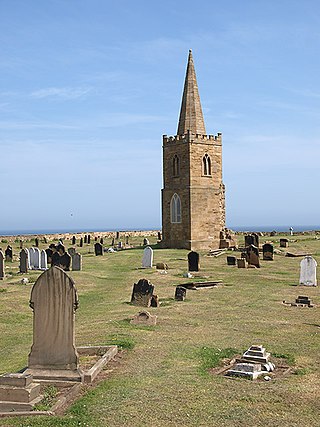
St Germain's Churchyard is a large cemetery overlooking the North Sea at Marske-by-the-Sea, North Yorkshire, England. Its church tower is a grade II listed structure at the midpoint to the yard and a landmark for sailors out on the sea. It is a remnant of a demolished church, services at St Germain's were replaced in 1876 by St Mark's.

