Sandsend

Last updated

Sandsend
Sandsend - geograph.org.uk - 1072.jpg
Sandsend from Sandsend beach
North Yorkshire UK location map (2023).svg
Red pog.svg
Sandsend
Location within North Yorkshire
OS grid reference NZ863125
Civil parish
Unitary authority
Ceremonial county
Region
Country England
Sovereign state United Kingdom
Police North Yorkshire
Fire North Yorkshire
Ambulance Yorkshire
UK Parliament
List of places
UK
England
Yorkshire
54°30′03″N0°40′06″W / 54.50075°N 0.66845°W / 54.50075; -0.66845

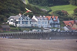
Sandsend is a small fishing village, near to Whitby in the Scarborough district of North Yorkshire, England. It forms part of the civil parish of Lythe. It is the birthplace of fishing magnate George Pyman. Originally two villages, Sandsend and East Row, the united Sandsend has a pub and restaurant. A large part of the western side of the village, in The Valley, is still owned by Mulgrave Estate. The Valley is one of the most expensive areas to buy property on the Yorkshire Coast.

Contents

History

Sandsend and the neighbouring village of East Row began as separate villages but were joined when extra cottages were built for workers in the alum industry. [1] Sandsend was also buoyed by tourism from the Whitby, Redcar and Middlesbrough Union Railway, which ran through the village from 1855 to 1958. [1] The local station was Sandsend railway station, which opened in 1883 and was closed in 1958. [2]

In the 1947 British comedy drama Holiday Camp , the opening shots of a train arriving at a cliff-top station and passengers boarding buses outside the station were filmed at Sandsend. [3]

Geography

Two becks empty into the North Sea at Sandsend: Sandsend Beck and East Row Beck. Both of these becks flow through Mulgrave Woods and were bridged by the railway on high viaducts across the village. [4]

Transport

The principal public transport serving Sandsend is the Arriva North East 4 & X4 bus service, which runs from Whitby up the coast to Middlesbrough. [5] The main road through the town is the A174 which runs from Whitby to Thornaby-On-Tees.

Sandsend is located on the coastal part of the 110-mile (180 km) Cleveland Way and it follows the course of the old railway line northwards. [6]

See also

Related Research Articles

<span class="mw-page-title-main">North York Moors</span> National park in North Yorkshire, England

The North York Moors is an upland area in north-eastern Yorkshire, England. It contains one of the largest expanses of heather moorland in the United Kingdom. The area was designated as a National Park in 1952, through the National Parks and Access to the Countryside Act 1949. Covering an area of 554 sq mi (1,430 km2), the National Park has a population of 23,380. It is administered by the North York Moors National Park Authority, whose head office is based in Helmsley.

<span class="mw-page-title-main">River Esk, North Yorkshire</span> River in North Yorkshire, England

The River Esk is a river in North Yorkshire, England that empties into the North Sea at Whitby after a course of around 28 miles (45 km) through the valley of Eskdale, named after the river itself. The river's name is derived from the Brythonic word "isca" meaning "water". The Esk is the only major river in Yorkshire that flows directly into the North Sea; all other watercourses defined as being major rivers by the Environment Agency, either flow to the North Sea via the River Tees or the Humber Estuary.

<span class="mw-page-title-main">Saltburn-by-the-Sea</span> Town in North Yorkshire, England

Saltburn-by-the-Sea, commonly referred to as Saltburn, is a seaside town in Redcar and Cleveland, North Yorkshire, England, around 26 miles (42 km) south-east of Hartlepool and southeast of Redcar.

<span class="mw-page-title-main">Esk Valley line</span> Railway line between Middlesbrough and Whitby, England

<span class="mw-page-title-main">Staithes</span> Village in North Yorkshire, England

Staithes is a seaside village in North Yorkshire, England. Easington and Roxby Becks, two brooks that run into Staithes Beck, form the border between the unitary authorities of North Yorkshire and Redcar and Cleveland. The area located on the Redcar and Cleveland side is called Cowbar. Formerly one of the many fishing centres in England, Staithes is now largely a tourist destination within the North York Moors National Park.

<span class="mw-page-title-main">Commondale railway station</span> Railway station in North Yorkshire, England

Commondale is a railway station on the Esk Valley Line, which runs between Middlesbrough and Whitby via Nunthorpe. The station, situated 16 miles 72 chains (27.2 km) south-east of Middlesbrough, serves the village of Commondale, Scarborough in North Yorkshire, England. It is owned by Network Rail and managed by Northern Trains.

<span class="mw-page-title-main">Danby railway station</span> Railway station in North Yorkshire, England

Danby is a railway station on the Esk Valley Line, which runs between Middlesbrough and Whitby via Nunthorpe. The station, situated 15 miles 9 chains (24.3 km) west of Whitby, serves the villages of Ainthorpe and Danby, Scarborough in North Yorkshire, England. It is owned by Network Rail and managed by Northern Trains.

<span class="mw-page-title-main">Lealholm railway station</span> Railway station in North Yorkshire, England

Lealholm is a railway station on the Esk Valley Line, which runs between Middlesbrough and Whitby via Nunthorpe. The station, situated 11 miles 40 chains (18.5 km) west of Whitby, serves the village of Lealholm, Scarborough in North Yorkshire, England. It is owned by Network Rail and managed by Northern Trains.

<span class="mw-page-title-main">Glaisdale railway station</span> Railway station in North Yorkshire, England

Glaisdale is a railway station on the Esk Valley Line, which runs between Middlesbrough and Whitby via Nunthorpe. The station, situated 9 miles 33 chains (15.1 km) west of Whitby, serves the village of Glaisdale in North Yorkshire, England. It is owned by Network Rail and managed by Northern Trains.

<span class="mw-page-title-main">Whitby railway station</span> Railway station in North Yorkshire, England

Whitby is a railway station serving the town of Whitby in North Yorkshire, England. It is the southern terminus of the Esk Valley Line from Middlesbrough. The station is owned by Network Rail and services operated by Northern Trains for mainline services and the North Yorkshire Moors Railway for heritage services.

<span class="mw-page-title-main">Whitby, Redcar and Middlesbrough Union Railway</span> Former railway line in Yorkshire, England

The Whitby, Redcar and Middlesbrough Union Railway (WRMU), a.k.a. the Whitby–Loftus Line, was a railway line in North Yorkshire, England, built between 1871 and 1886, running from Loftus on the Yorkshire coast to the Esk at Whitby, and connecting Middlesbrough to Whitby along the coast.

<span class="mw-page-title-main">Sandsend railway station</span> Former railway station in the North Riding of Yorkshire, England

Sandsend railway station was a railway station on the Whitby, Redcar and Middlesbrough Union Railway. It was opened on 3 December 1883, and served the villages of Sandsend and Lythe. It closed on 5 May 1958. The station building is now a private residence. It was the only station between Whitby and Loftus not to possess a passing loop.

<span class="mw-page-title-main">Kettleness railway station</span> Former railway station in the North Riding of Yorkshire, England

Kettleness was a railway station on the Whitby, Redcar and Middlesbrough Union Railway from 1883 to 1958 serving the remote village of Kettleness. The main station building is still extant and serves as a scouting centre.

<span class="mw-page-title-main">Staithes railway station</span> Former railway station in the North Riding of Yorkshire, England

Staithes railway station was a railway station on the Whitby Redcar and Middlesbrough Union Railway, serving the villages of Staithes and Dalehouse in North Yorkshire, England. It was opened on 3 December 1883.

<span class="mw-page-title-main">Runswick Bay</span> Village in North Yorkshire, England

Runswick Bay is a bay in the Scarborough Borough of North Yorkshire, England. It is also the name of a village located on the western edge of the bay. It is 5 miles (8 km) north of Whitby, and close to the villages of Ellerby and Hinderwell. It is a popular tourist attraction due to its picturesque cliffside village, stunning coastal walks, fossil hunting and Runswick Sands, a white sand beach. It is on the Cleveland Way national trail. Runswick Bay was chosen as Beach of the Year 2020 by The Sunday Times.

<span class="mw-page-title-main">Port Mulgrave, North Yorkshire</span> Former port in North Yorkshire, England

Port Mulgrave is a derelict former ironstone exporting port on the North Yorkshire coast midway between Staithes and Runswick Bay in the civil parish of Hinderwell. Rows of domestic properties and individual houses exist on the top of the cliff.

<span class="mw-page-title-main">Kettleness</span> Hamlet in North Yorkshire, England

Kettleness, is a hamlet in the Scarborough District of North Yorkshire, England. The settlement only consists of half-a-dozen houses, but up until the early 19th century, it was a much larger village. However, most of that village, which was on the headland, slipped into the sea as a result of instability caused by quarrying for the alum industry. Kettleness became a smaller settlement, with houses rebuilt slightly further inland.

<span class="mw-page-title-main">Grinkle Mine</span> Former ironstone mine in North Yorkshire, England

Grinkle Mine, was an ironstone mine working the main Cleveland Seam near to Roxby in North Yorkshire, England. Initially, the ironstone was mined specifically for the furnaces at the Palmer Shipbuilders in Jarrow on the River Tyne, but later, the mine became independent of Palmers. To enable the output from the mine to be exported, a 3-mile (4.8 km) narrow-gauge tramway was constructed that ran across three viaducts and through two tunnels to the harbour of Port Mulgrave, where ships would take the ore directly to Tyneside.

<span class="mw-page-title-main">Staithes Viaduct</span> Former railway viaduct in North Yorkshire, England

Staithes Viaduct was a railway bridge that straddled Staithes Beck at Staithes, Yorkshire, England. It was north of the closed Staithes railway station. It was known for an anemometer, a fitting to tell the signaller if winds across the viaduct were too strong for crossing trains.

<span class="mw-page-title-main">Kilton Viaduct</span> Viaduct in Yorkshire, England

Kilton Viaduct was a railway viaduct that straddled Kilton Beck, near to Loftus, in North Yorkshire, England. The viaduct was opened to traffic in 1867, however in 1911, with the viaduct suffering subsidence from the nearby ironstone mining, the whole structure was encased in waste material from the mines creating an embankment which re-opened fully to traffic in 1913. The railway closed in 1963, but then in 1974, it re-opened as part of the freight line to Boulby Mine carrying potash traffic.

References

  1. 1 2 Dillon, Paddy (2005). Cleveland Way. Cicerone. p. 152. ISBN   978-1-85284-447-9 . Retrieved 11 October 2011.
  2. Butt, R.V.J. (1995). The Directory Of Railway Stations. Patrick Stephens Limited. ISBN   1-85260-508-1.
  3. "Holiday Camp". REELSTREETS. Retrieved 29 November 2018.
  4. "Lost Viaducts Brought The Coast Together". Whitby Gazette. 6 May 2014. Retrieved 8 November 2015.
  5. "X4 - Buses from Middlesbrough to Loftus and Whitby". getdown.org.uk. Retrieved 20 June 2017.
  6. "The Cleveland Way". National Trails. Retrieved 8 November 2015.