The Mesolithic or Middle Stone Age is the Old World archaeological period between the Upper Paleolithic and the Neolithic. The term Epipaleolithic is often used synonymously, especially for outside northern Europe, and for the corresponding period in the Levant and Caucasus. The Mesolithic has different time spans in different parts of Eurasia. It refers to the final period of hunter-gatherer cultures in Europe and the Middle East, between the end of the Last Glacial Maximum and the Neolithic Revolution. In Europe it spans roughly 15,000 to 5,000 BP; in the Middle East roughly 20,000 to 10,000 BP. The term is less used of areas farther east, and not at all beyond Eurasia and North Africa.

Almería is a province of the autonomous community of Andalusia, Spain. It is bordered by the provinces of Granada, Murcia, and the Mediterranean Sea. Its capital is the homonymous city of Almería.
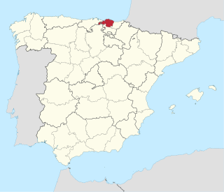
Biscay is a province of Spain and a historical territory of the Vascongadas, heir of the ancient Lordship of Biscay, lying on the south shore of the eponymous bay. The capital and largest city is Bilbao.

Svarthola or Vistehola is a cave and an archaeological site, located in Randaberg municipality in Rogaland county, Norway. The 9 m (30 ft) deep cavern is located on the Viste farm, about 10 km (6.2 mi) northwest of the city of Stavanger, situated near the shore of the Visteviga bay, at the mouth of the Hafrsfjorden. The site has yielded numerous Neolithic artifacts that have been excavated and discovered in and around the cave.

Karrantza Harana/Valle de Carranza, is a town and municipality located in the province of Biscay, in the Basque Country. It is located in the comarca of Enkarterri and it is the westernmost and largest municipality of the province.

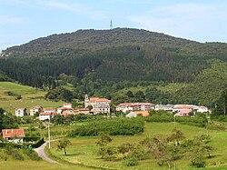
Ajangiz is a town and municipality in the province of Biscay, in the Basque Country. It is located in the Busturialdea comarca, and was part of the municipality of Gernika-Lumo between 1940 and 1991.

Galdames is a town, valley, and municipality located in the Biscay province of the autonomous community of Basque Country, Spain.

Mañaria is an elizate, town and municipality located in the province of Biscay, in the Basque Country, Spain. Mañaria is part of the comarca of Durangaldea and has a population of 459 inhabitants as of 2006 according to the Spanish National Statistics Institute.

Mundaka is a town and municipality located in the province of Biscay, in the autonomous community of Basque Country, in northern Spain. Mundaka is internationally renowned for the surfing community that takes advantage of its coast and unique oceanic conditions.

Artziniega is a town and municipality in the province of Álava, in the Basque Country, northern Spain. Located in the northwest of Araba, on the border with Burgos, Castile and León and Biscay, it was at the junction between the old Kingdom of Castile and the ports of the Bay of Biscay.
Laguna de las Momias, also known as Laguna de los Cóndores is an archaeological site located in Leimebamba, Chachapoyas province, in the Amazonas Region of Peru, excavated by the archaeologist Federico Kauffmann Doig. The site is called Lagoon of the Condors because the people who found the lagoon would see these birds soar near the lagoon; it also obtained the name Lagoon of the Mummies because of the mummy findings around the area. The Chachapoyas were an old civilization that was located in the northern forest in the time of 900 a.c. This culture had been unknown by archaeologists for hundreds of years until the mummies appeared.

The greater Basque Country comprises the Autonomous Communities of the Basque Country and Navarre in Spain and the Northern Basque Country in France. The Prehistory of the region begins with the arrival of the first hominin settlers during the Paleolithic and lasts until the conquest and colonisation of Hispania by the Romans after the Second Punic War, who introduced comprehensive administration, writing and regular recordings.
The prehistory in the Valencian Community refers to the period from the Paleolithic, including the appearance of the first populations, until the appearance of colonizing peoples, in the territory of the Valencian Community.

Cuarenta Casas(literally "40 houses") is an archaeological site in the northern Mexican state of Chihuahua. Construction of the site is attributed to the Mogollon culture.

Cueva de la Candelaria is an archaeological site located the Mexican state of Coahuila. It is a cave that was used as cemetery by nomad visitors. Early site research was made in 1953 and there was a later season in 1954. As a result of these investigations, many materials were recovered and are kept by Instituto Nacional de Antropología e Historia (INAH).

Huápoca is an archaeological site located 36 kilometers west of Ciudad Madera, in the Huápoca Canyon region, northwest of the Mexican state of Chihuahua.

The 1980 Ispaster attack was a gun and grenade attack by the Basque separatist organisation ETA which occurred on 1 February 1980 near the Basque town of Ispaster. The targets were a convoy of civil guards who were escorting workers and weapons from the nearby Esperanza y Cia Arms factory to Bilbao. A total of six civil guards were killed, while two ETA members were killed by hand grenades that they had thrown. The attack was the deadliest of 1980, the year when ETA killed more people than any other.

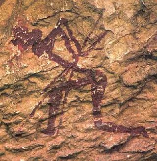
The La Garma cave complex is a parietal art-bearing paleoanthropological cave system in Cantabria, Spain. It is located just north of the village of Omoño, part of the municipality of Ribamontán al Monte. The cave complex is noted for one of the best preserved floors from the Paleolithic containing more than 4,000 fossils and more than 500 graphical units. It is part of the Cave of Altamira and Paleolithic Cave Art of Northern Spain World Heritage Site.

Vasco-Cantabria, in archaeology and the environmental sciences, is an area on the northern coast of Spain. It covers similar areas to the northern parts of the adjacent modern regions of the Basque country and Cantabria. In geology the "Vasco-Cantabrian Basin" or "Basque-Cantabrian Basin" covers the area and the seas off the coast in the Bay of Biscay, an area between the Iberian and European tectonic plates.
Stone Age in Azerbaijan is divided into the Paleolithic, Mesolithic, and Neolithic periods. It was studied in Karabakh, Gazakh, Lerik, Gobustan, and Nakhchivan. Stone materials belonging to the Stone Age were found by Mammadali Huseynov in the Shorsu gorge located near the village of Gyrag Kasaman in Qazakh region. According to his research, people have first settled in the territory of Azerbaijan 2 million years ago. The Stone Age era involved two different human species: Homo neanderthalensis and Homo sapiens.