| Fort Kongenstein | |
|---|---|
| Ada Foah, Ghana | |
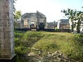
 Remains of Fort Kongenstein | |
| Site information | |
| Condition | ruins |
| Location | |
 Fort Kongenstein  Fort Kongenstein | |
| Coordinates | 5°47′N0°38′E / 5.78°N 0.63°E |
| Site history | |
| Built | 1783 |
| Fate | washed away by the sea |
Fort Kongenstein (Danish : Fort Kongensten) was a Danish trading fort located in Ada Foah, Ghana built in 1783. [1] A greater portion of the fort has since been washed away by the sea waves. [2]