
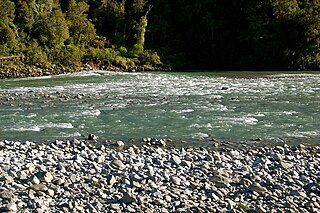
The Ahaura River is in the South Island of New Zealand. This river drains the western flanks of the Southern Alps and flows into the Grey River.

The Mangles River is in the South Island of New Zealand. Its main tributary is the Tutaki River but it is also fed by water flowing off the Braeburn Range. It feeds into the Buller River near the town of Murchison. The river is popular destination for kayaking and trout fishing.

Cape Foulwind is a headland on the West Coast of the South Island of New Zealand, overlooking the Tasman Sea. It is located 11 kilometres (6.8 mi) west of the town of Westport. There is a lighthouse located on a prominent site on the headland. A walkway beginning at the lighthouse carpark traverses the rocky headland to Tauranga Bay and passes close by a colony of New Zealand fur seals. There is limestone quarry in the area, and a cement works operated nearby from 1958 to 2016.
The Inangahua River is located in the northwest of New Zealand’s South Island. It is a major tributary of the Buller River, which it joins at the town of Inangahua Junction.

The Ashley River is in Canterbury region of New Zealand. It flows generally southeastwards for 65 kilometres (40 mi) before entering the Pacific Ocean at Waikuku Beach, Pegasus Bay north of Christchurch. The town of Rangiora is close to the south bank of the Ashley River. The river's official name was changed from Ashley River to the dual name Ashley River / Rakahuri by the Ngāi Tahu Claims Settlement Act 1998.

The Stillwater Ngākawau Line (SNL), formerly the Stillwater–Westport Line (SWL) and the Ngakawau Branch, is a secondary main line, part of New Zealand's national rail network. It runs between Stillwater and Ngakawau via Westport on the West Coast of the South Island. It was one of the longest construction projects in New Zealand's history, with its first section opened in 1889 and the full line completed 1942.

Seddonville is a lightly populated locality on the West Coast of New Zealand's South Island. It is most famous for the historical role it played in New Zealand's coal mining industry.
The Mōkihinui River is a river located on the West Coast of New Zealand's South Island, about 40 kilometres north of Westport. Meridian Energy had proposed the Mokihinui Hydro project on the river in 2007 but it was cancelled in May 2012. In 2019, it was announced that large parts of the river catchment, including 15 km (9.3 mi) of river bed, would be added to Kahurangi National Park.

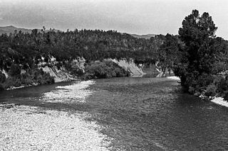
The Waiheke River is a river of the West Coast Region of New Zealand's South Island. It flows west from its origins on Mount Barron in the Southern Alps to reach the Ahaura River, which it forms where it joins the Tūtaekurī River, 20 kilometres northwest of Lake Sumner.

Tokomaru railway station was a station on the North Island Main Trunk. It served Tokomaru in Horowhenua District the Manawatū-Whanganui region of New Zealand.

Utiku railway station was a station on the North Island Main Trunk in New Zealand, and in the Manawatū-Whanganui region. It opened in 1904 and closed in 1986. It was part of the 13+1⁄2 mi (21.7 km) Mangaweka to Taihape section, officially opened by the Prime Minister, Richard Seddon, on 21 November 1904. It closed in 1986. A passing loop remains.

The Makerua Swamp is an area of the Opiki District of the Manawatū-Whanganui region of New Zealand. In the early 20th century it was the location of flax mills that operated on the banks of the Manawatū River. Flax fibre from New Zealand flax or harekeke, was an important produce of New Zealand. The swamp covered about 5,800 ha.

The Stephens Island / Takapourewa lighthouse is one of New Zealand most powerful lights with a range of 18 nautical miles. Perched 183 metres (600 ft) up, on top of Stephens Island, it guards Cook Strait and Tasman Bay / Te Tai-o-Aorere, at the top of the South Island / Te Wai Pounamu.The light flashes white once every six seconds from a white cast iron tower.

Puketutu was a flag station on the North Island Main Trunk line, in the Waitomo District of New Zealand. It was 7.21 km (4.48 mi) north of Kopaki and 8.24 km (5.12 mi) south of Waiteti.

Matapuna had several sidings on the North Island Main Trunk line, in the Ruapehu District of New Zealand, serving the east Taumarunui suburb on the north bank of the Whanganui River. It was 2.9 km (1.8 mi) north west of Manunui and 2.95 km (1.83 mi) east of Taumarunui. Work was largely complete by May 1903, and freight was handled from 22 June 1903. A fixed signal was placed at the station and a distant at the bridge in 1917 and the ballast pit siding was interlocked by tablet in 1918. A racecourse opened to the south of the bridge in 1916 and some trains served the course on race days, though no platform appears on aerial photos and only the ballast pit was mapped.

Horopito was a station on the North Island Main Trunk line, in the Ruapehu District of New Zealand. It served the small village of Horopito and lies just to the north of two of the five largest NIMT viaducts. It and Pokaka also lay to the south of Makatote Viaduct, the late completion of which held up opening of the station.
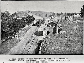
Makotuku is a locality in the Manawatu-Whanganui Region of New Zealand's North Island, about 3 km2 (1.2 sq mi) west of Ormondville.

Westhaven Marine Reserve is a marine reserve covering an area of 536 hectares in the Whanganui Inlet at the top of New Zealand's South Island. It was established in 1994 and is administered by the Department of Conservation.
Haywrights was a New Zealand department store chain that was founded in 1929 and eventually grew to be one of the largest department store chains in New Zealand.
Newton River in the Tasman District ), flows west and then south for about 20 km (12 mi) from Mount Newton to the Buller River, 17 km (11 mi) west of Murchison. Near its mouth it is crossed by SH6 on a steel truss bridge with a 120 ft (37 m) main span and two 30 ft (9.1 m) side spans.

