
The Auckland Harbour Bridge is an eight-lane motorway bridge over the Waitematā Harbour in Auckland, New Zealand. It joins St Marys Bay on the Auckland city side with Northcote on the North Shore side. It is part of State Highway 1 and the Auckland Northern Motorway. The bridge is operated by the NZ Transport Agency (NZTA). It is the second-longest road bridge in New Zealand, and the longest in the North Island.

Queen Street is the major commercial thoroughfare in the Auckland CBD, Auckland, New Zealand's main population centre. The northern end is at Queens Wharf on the Auckland waterfront, adjacent to the Britomart Transport Centre and the Downtown Ferry Terminal. The road is close to straight, the southern end being almost three kilometres away in a south-southwesterly direction on the Karangahape Road ridge, close to the residential suburbs in the interior of the Auckland isthmus.

Auckland City was a territorial authority with city status covering the central isthmus of the urban area of Auckland, New Zealand. It was governed by the Auckland City Council from 1989 to 2010, and as a territory within the wider Auckland Region, was also governed by Auckland Regional Council. Auckland City was disestablished as a local authority on 1 November 2010, when Auckland City Council was amalgamated with other councils of the Auckland Region into the new Auckland Council. At the time of its disestablishment, the city had a resident population of around 450,000.

Viaduct Harbour, formerly known as Viaduct Basin, is a former commercial harbour on the Auckland waterfront that has been turned into a development of mostly upscale apartments, office space and restaurants. It is located on the site of a formerly run-down area of the Freemans Bay / Auckland CBD waterfront in Auckland, New Zealand. As a centre of activity of the 2000 America's Cup hosted by the Royal New Zealand Yacht Squadron, as well as the 2022 Rally New Zealand, the precinct enjoyed considerable popularity with locals and foreign visitors.

Mechanics Bay is a reclaimed bay on the Waitematā Harbour in Auckland, New Zealand. It is also the name of the area of the former bay that is now mainly occupied by commercial and port facilities. Sometimes the bay formed between Tāmaki Drive and the western reclamation edge of Fergusson Container Terminal is also referred to as Mechanics Bay.
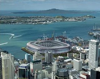
Stadium New Zealand, often called the Waterfront Stadium, was the provisional name for a national stadium proposed for the Auckland waterfront to host the 2011 Rugby World Cup. The stadium never advanced beyond a concept design.

Waihorotiu, sometimes called the Waihorotiu Stream and the 'Queen Street River', is a stream that ran down the Queen Street gully in the Auckland CBD, New Zealand, into the Waitemata Harbour. It has long since been covered over and put underground by the urbanisation of the area.

Ports of Auckland Limited (POAL), the successor to the Auckland Harbour Board, is the Auckland Council-owned company administering Auckland's commercial freight and cruise ship harbour facilities. As the company operates all of the associated facilities in the Greater Auckland area, this article is about both the current company and the ports of Auckland themselves.

The Wynyard Quarter is a reclaimed piece of land on the Waitematā Harbour at the western edge of the Auckland waterfront, New Zealand.

The Auckland waterfront is a city-side stretch of the southern Waitematā Harbour coastline in Auckland, New Zealand. Previously mostly dominated by Ports of Auckland uses, from the 2000s on it is becoming increasingly open to recreational public use, with a number of former wharves being converted to office, entertainment, and later also some residential uses.

The Royal New Zealand Yacht Squadron is a New Zealand yacht club, and the club behind New Zealand's America's Cup campaigns, under the guises of New Zealand Challenge and Team New Zealand. It held the America's Cup from 1995 until 2003, becoming in 2000 the first non-American holder to successfully defend the trophy. After Team New Zealand's victory in the 2017 event, the Royal New Zealand Yacht Squadron are the current holders of the America's Cup. On March 21, 2021, they beat Circolo della Vela Sicilia's Luna Rossa Challenge to again win the 2021 America's Cup.

The Auckland Central Business District (CBD), or Auckland city centre, is the geographical and economic heart of the Auckland metropolitan area. It is the area in which Auckland was established in 1840, by William Hobson on land gifted by mana whenuahapū Ngāti Whātua Ōrākei. It is New Zealand's leading financial hub, and the centre of the country's economy; the GDP of the Auckland Region was NZD$139 billion in the year ending September 2023.
Point Britomart was a headland in the Waitematā Harbour, in Auckland, New Zealand. Located between Commercial Bay and Official Bay, the point was later quarried away to produce fill for land reclamation in Mechanics Bay, and almost no physical trace remains at street level in what is today an area of the Auckland CBD and the Auckland waterfront.

The Victoria Park Tunnel is a motorway tunnel completed in 2012 on New Zealand State Highway 1 in Auckland, New Zealand, taking northbound traffic off the Victoria Park Viaduct, which was converted to all southbound traffic. It lies mostly under Victoria Park.

Auckland Council is the local government council for the Auckland Region in New Zealand. It is a territorial authority that has the responsibilities, duties and powers of a regional council and so is a unitary authority, according to the Local Government Act 2009, which established the council. The governing body consists of a mayor and 20 councillors, elected from 13 wards. There are also 149 members of 21 local boards who make decisions on matters local to their communities. It is the largest council in Oceania, with a $3 billion annual budget, $29 billion of ratepayer equity, and 9,870 full-time staff as of 30 June 2016. The council began operating on 1 November 2010, combining the functions of the previous regional council and the region's seven city and district councils into one "super council" or "super city".
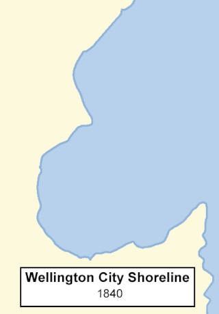
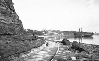
The reclamation of Wellington Harbour started in the 1850s, in order to increase the amount of usable land for the then new City of Wellington. Land plots in the early city were scarce, with little room for public buildings and parks, as well as inadequate dockside areas for shipping. Reclamation progressively advanced into the harbour throughout the 19th and 20th centuries, providing room for public, commercial and industrial areas for the city. Large reclamations were made in the 1960s and '70s to meet the demands of container shipping and new cargo handling methods.
Queens Wharf is a concrete wharf in Auckland, New Zealand, that continues off Queen Street. It opened in 1913, replacing the Queen Street Wharf, a succession of wooden wharves first built in 1852. Queens Wharf was owned and used by Ports of Auckland until 2010.

Wynyard Crossing is a modern double bascule pedestrian and cyclists' bridge built in 2011 in Auckland, New Zealand. It connects the redeveloped Wynyard Quarter with Te Wero Island and the existing Viaduct Harbour entertainment district, and thereby, with the wider Auckland waterfront.

Wellington Harbour Board was the body which formerly managed the shipping and commercial affairs of the port of Wellington in New Zealand. It was constituted in 1880 and was disestablished in 1989.

Tamaki Drive is the coastal road which follows the contours of the Waitematā Harbour, Auckland, New Zealand. The road links the suburbs Ōrākei, Mission Bay, and Kohimarama ending in Saint Heliers providing easy access to the local beaches. Tamaki Drive was completed in 1932 and incorporates The Strand, Bice Esplanade and, what was once part of the old Kohimarama Road. It is also referred to as the Waterfront Road. Tamaki Drive is a flat road around 8 km long and popular with walkers, runners and roller skaters, and includes a dedicated cycle lane. Those travelling along Tamaki Drive can find scenic highlights and peaceful views across the harbour to the volcanic island Rangitoto. The cliffs backing onto Tamaki Drive are made of Waitematā Sandstone strata clothed in places with pōhutukawa. These trees seem to flower out of season, because these are actually Kermadec pōhutukawa with small distinctive roundish leaves.

