The New Zealand Great Walks are a set of popular tramping tracks developed and maintained by the Department of Conservation.[1] They are New Zealand's premier tracks, through areas of some of the best scenery in the country, ranging from coastlines with beaches to dense rain forests and alpine terrain. The tracks are maintained to a high standard, making it easier for visitors to explore some of the most scenic parts of New Zealand's backcountry.
The walks range from 32 kilometres (20mi) length to 82 kilometres (51mi) in length and take between 3 and 6 days to complete, with the Whanganui Journey on river being 145 kilometres (90mi) long over 5 days.[2]
Only the Tongariro Northern Circuit and the Kepler Track are loop walks, all other Great Walks require transport to return to the starting point.
History
The Great Walks network was established by the Department of Conservation in 1992.[1] The network was established both as a way to advertise hiking in New Zealand, but also as a means of managing and conserving the most popular tracks which were increasingly being damaged by unrestricted tourism.[3]
The backcountry huts are conveniently located, comfortable, well-equipped, and high capacity. Both the huts and tracks on the Great Walks are of a higher standard than other tramping tracks in the country. These tracks are very popular with overseas visitors, partly due to their heavy promotion by the Department of Conservation and tourism operators. All of the Great Walks have booking systems to manage visitor pressure. Guided walks are available through private operators along many of the walks.
There is no charge required for walking access to the Great Walks, however, charges apply for overnight accommodation at the huts or campsites. To conserve the tracks, it is illegal to camp within 500 metres (1,600ft) of a Great Walk track or 1 kilometre (0.62mi) of the Milford Track except at designated campsites.[5] Sections of the Abel Tasman Coastal Track are particularly popular for day walks without overnight accommodation, as even the middle sections are serviced by water taxis.
List of routes
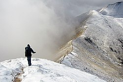
Sub-tropical vegetation along Heaphy RiverMountain pass on Milford TrackAn alpine section of the Kepler Track after snowfallTypical swing bridge on Waikaremoana Great WalkEmerald Lakes in the volcanic landscape of Tongariro
Whanganui Journey — this is actually not a walk but a canoe voyage on New Zealand's longest navigable river. It is however managed under the Great Walks system.
Heaphy Track – at 82kilometres the longest of the walking tracks, delivering the biggest contrast from palm-fringed beaches to sub-alpine tussock grasslands.
Routeburn Track – at 32kilometres the shortest of the walking tracks.
In July 2019, it was decided that the 61-km Hump Ridge Track would become the 11th Great Walk. There was an upgrade to track and hut facilities, costing approx NZ$5m. The goal was to have this track join the Great Walks network in 2023.[10] but after delays it opened as a Great Walk on 25 October 2024.
This page is based on this Wikipedia article Text is available under the CC BY-SA 4.0 license; additional terms may apply. Images, videos and audio are available under their respective licenses.