Related Research Articles

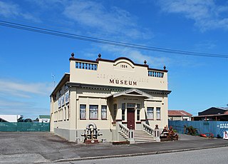
Westport is a town in the West Coast region of the South Island of New Zealand. Established in 1861, it is the oldest European settlement on the West Coast. Originally named Buller, it is on the right bank and at the mouth of the Buller River, close by the prominent headland of Cape Foulwind. It is connected via State Highway 6 with Greymouth, 100 kilometres (62 mi) to the south, and with Nelson 222 kilometres (138 mi) in the northeast, via the Buller Gorge. The population of the Westport urban area was 4,250 as of June 2023. The Buller District had a population of 9,670.

The Buller Gorge is a gorge located in the northwest of the South Island of New Zealand. The Buller River flows through the deep canyon between Murchison and Westport. Land Information New Zealand lists two sections for the gorge, Upper Buller Gorge and Lower Buller Gorge. State Highway 6 runs alongside, but considerably above, the river through the gorge. The Stillwater - Westport Line railway also runs through the gorge.

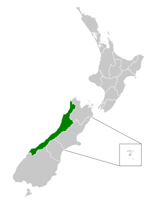
Buller District is one of 53 districts of New Zealand, and is within the West Coast Region. It covers Westport, Karamea, Reefton and Inangahua Junction.
The Papahaua Range is a mountain range on the West Coast of New Zealand's South Island east of the town of Westport. It is a geological continuation of the Paparoa Range that is south of the Buller River and it runs north from the Buller Gorge to the Mōkihinui River. At its north end, it meets the Glasgow Range.
Buller District Council is the territorial authority for the Buller District of New Zealand.

The Ōhikaiti River is a river of the West Coast Region of New Zealand's South Island. It flows north from Mount Galileo, in the Paparoa Range, paralleling the course of the larger Ōhikanui River which lies two kilometres to the west. The Ōhikaiti empties into the Buller River at the Buller Gorge, 15 kilometres southwest of Westport.

The Orowaiti River is a river of the West Coast Region of New Zealand's South Island. The smaller of the two rivers which run through the town of Westport, it reaches the Karamea Bight three kilometres to the east of its larger neighbour, the Buller River.

Buller High School is a secondary school in the town of Westport, New Zealand. The school has a roll of over 360 students, all Year 9 to Year 13. As well as students from Westport, the school has a large number of students from nearby towns that do not have high schools of their own, such as Waimangaroa, Granity, and Seddonville. The school was founded in 1922, although has ties to earlier secondary schooling in the Buller district.
Grey County was one of the counties of New Zealand in the South Island.
Waimea County was one of the counties of New Zealand on the South Island.

Carters Beach is a suburb of Westport on the West Coast of New Zealand's South Island. Located 6 kilometres (4 mi) west of Westport on State Highway 67A, it offers a pristine sheltered sandy beach on the West Coast suitable for swimming. From the Buller River jetty at the east end of Carters Beach, west to Cape Foulwind, the beach runs for more than 9 uninterrupted kilometres.

The Westport News is an independently-owned evening newspaper published in Westport, New Zealand. It is published on weekdays, and is one of New Zealand's smallest independent newspapers. The Westport News is distributed from Karamea in the north to Punakaiki in the south and as far inland as Reefton.

The Mayor of Buller is the head of the municipal government of Buller District, New Zealand. The mayor is directly elected using the first-past-the-post electoral system.

Westland County, also known as County of Westland, was a local government area on the West Coast of New Zealand's South Island. It existed from 1868 to 1873, and then from 1876 until 1989. In its first incarnation, it constituted the government for the area that was split from the Canterbury Province, with the West Coast Gold Rush having given the impetus for that split. It had the same administrative powers as a provincial council, but the legislative power rested with Parliament in Wellington. The first Westland County was the predecessor to Westland Province.

The Charming Creek Tramway was a 9 kilometres (5.6 mi) long private bush tramway at Ngakawau in Buller District on the West Coast in New Zealand. It was used from 1903 or 1905 to 1958.

Inangahua County was one of the counties of New Zealand on the South Island.
Marlborough County was one of the counties of New Zealand on the South Island.
The West Coast District Health Board was a district health board with the focus on providing healthcare to the West Coast region of New Zealand. In July 2022, the West Coast DHB's functions and responsibilities were taken over by the national health service Te Whatu Ora.

Coast FM is a local radio station in Westport, New Zealand, to most of the West Coast Region. The station began in 1995 as Radio Fifeshire Westport in partnership with Fifeshire FM in Nelson, and started broadcasting in Hokitika and Greymouth in 1996. The station was rebranded as Coast FM in 1999, but is not related to Coast network that broadcasts in other parts of the country. It used to broadcast from the Westport News offices in the former BNZ building on Palmerston Street.
The Mayor of Westport officiated over the borough of Westport in on the West Coast of New Zealand's South Island. The office was created in 1873 when Westport was gazetted as a borough by the Nelson Provincial Council, and ceased with the 1989 local government reforms, when Westport Borough, Buller County and Inangahua County merged to form Buller District. The first mayor of Westport was James Wilson Humphrey.
References
- ↑ "Buller Heritage". Buller District Libraries. Retrieved 25 October 2013.
41°48′47″S171°47′35″E / 41.813°S 171.793°E
| | This West Coast Region (New Zealand) geography article is a stub. You can help Wikipedia by expanding it. |